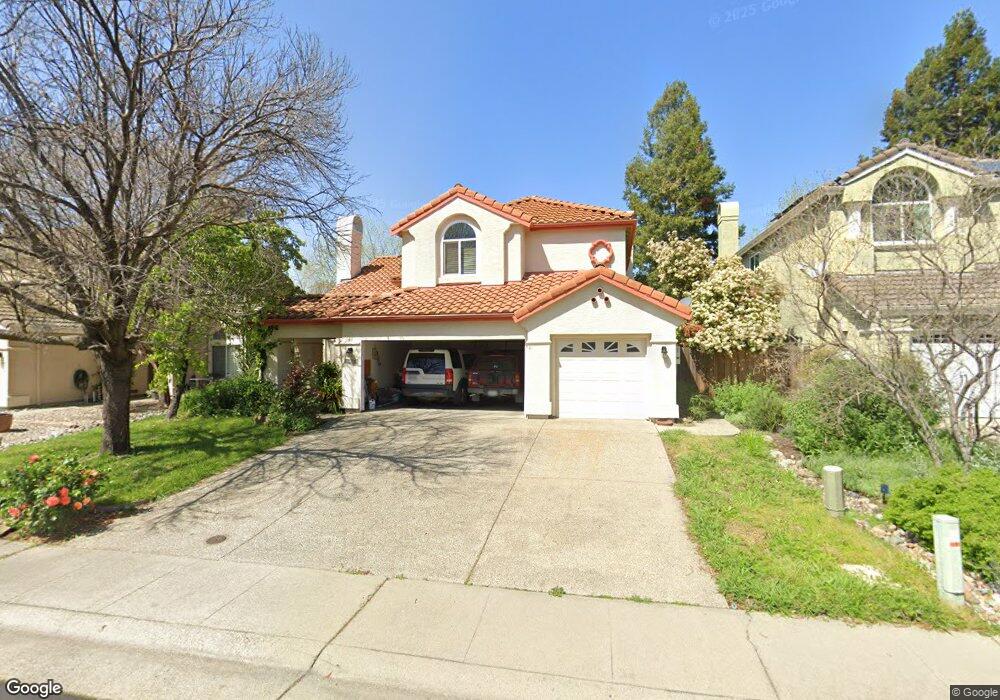
2601 Swindon Ct Rocklin, CA 95765
Stanford Ranch NeighborhoodEstimated Value: $701,000 - $789,000
4
Beds
3
Baths
2,575
Sq Ft
$287/Sq Ft
Est. Value
About This Home
This home is located at 2601 Swindon Ct, Rocklin, CA 95765 and is currently estimated at $739,295, approximately $287 per square foot. 2601 Swindon Ct is a home located in Placer County with nearby schools including Breen Elementary, Granite Oaks Middle, and Rocklin High.
Ownership History
Date
Name
Owned For
Owner Type
Purchase Details
Closed on
Jun 18, 2004
Sold by
Cullinan Frank and Comerate Lynda
Bought by
Torrelio Fernando
Current Estimated Value
Home Financials for this Owner
Home Financials are based on the most recent Mortgage that was taken out on this home.
Original Mortgage
$333,700
Outstanding Balance
$166,289
Interest Rate
6.29%
Mortgage Type
Purchase Money Mortgage
Estimated Equity
$573,006
Purchase Details
Closed on
Jun 9, 1995
Sold by
Christy Bruce and Christy Julie M
Bought by
Cullinan Frank
Home Financials for this Owner
Home Financials are based on the most recent Mortgage that was taken out on this home.
Original Mortgage
$203,150
Interest Rate
7.92%
Mortgage Type
Purchase Money Mortgage
Create a Home Valuation Report for This Property
The Home Valuation Report is an in-depth analysis detailing your home's value as well as a comparison with similar homes in the area
Home Values in the Area
Average Home Value in this Area
Purchase History
| Date | Buyer | Sale Price | Title Company |
|---|---|---|---|
| Torrelio Fernando | $500,000 | First American Title | |
| Cullinan Frank | $215,500 | Sierra Valley Title Company |
Source: Public Records
Mortgage History
| Date | Status | Borrower | Loan Amount |
|---|---|---|---|
| Open | Torrelio Fernando | $333,700 | |
| Previous Owner | Cullinan Frank | $203,150 | |
| Closed | Torrelio Fernando | $66,220 |
Source: Public Records
Tax History
| Year | Tax Paid | Tax Assessment Tax Assessment Total Assessment is a certain percentage of the fair market value that is determined by local assessors to be the total taxable value of land and additions on the property. | Land | Improvement |
|---|---|---|---|---|
| 2025 | $8,281 | $710,736 | $177,715 | $533,021 |
| 2023 | $8,281 | $683,139 | $170,815 | $512,324 |
| 2022 | $7,579 | $669,745 | $167,466 | $502,279 |
| 2021 | $6,395 | $557,000 | $139,300 | $417,700 |
| 2020 | $6,720 | $548,000 | $137,000 | $411,000 |
| 2019 | $6,318 | $542,000 | $135,500 | $406,500 |
| 2018 | $6,266 | $541,000 | $135,300 | $405,700 |
| 2017 | $5,838 | $476,000 | $119,000 | $357,000 |
| 2016 | $5,490 | $458,000 | $114,500 | $343,500 |
| 2015 | $5,241 | $443,000 | $110,800 | $332,200 |
| 2014 | $5,554 | $433,000 | $108,300 | $324,700 |
Source: Public Records
Map
Nearby Homes
- 5329 Wesley Rd
- 2211 Jason Ct
- 5030 Charter Rd
- 2024 Archer Cir
- 5116 Camden Rd
- 5112 Stratton Ct
- 4714 Durham Ct
- 3140 Golden Trail St
- 1914 Harvest Ct
- 4730 Stuart St
- 2408 Galloping Trail Ct
- 2712 Ashland Ct
- 3456 Hidden Ranch Loop
- 2611 Hoofbeat Ct
- 1707 Poppy Dr
- 2823 Broken Bit Ln
- 2904 Avon Rd
- 1701 Poppy Dr
- 1208 Reading Way Unit 80
- 810 Broken Bit Ct
- 2603 Swindon Ct
- 5363 Swindon Rd
- 5361 Swindon Rd
- 2605 Swindon Ct
- 2607 Swindon Ct
- 5359 Swindon Rd
- 5413 Quane Rd
- 2606 Swindon Ct
- 5357 Swindon Rd
- 2609 Swindon Ct
- 5408 Quane Rd
- 5411 Quane Rd
- 2608 Swindon Ct
- 5348 Swindon Rd
- 2611 Swindon Ct
- 5355 Swindon Rd
- 5409 Quane Rd
- 5406 Quane Rd
- 5346 Swindon Rd
- 2610 Swindon Ct
Your Personal Tour Guide
Ask me questions while you tour the home.