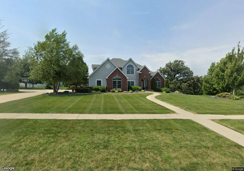
2603 Country Oak Dr Atlantic, IA 50022
Estimated Value: $462,000 - $746,000
5
Beds
3
Baths
2,674
Sq Ft
$230/Sq Ft
Est. Value
About This Home
This home is located at 2603 Country Oak Dr, Atlantic, IA 50022 and is currently estimated at $615,999, approximately $230 per square foot. 2603 Country Oak Dr is a home located in Cass County with nearby schools including Washington Elementary School, Schuler Elementary School, and Atlantic Middle School.
Ownership History
Date
Name
Owned For
Owner Type
Purchase Details
Closed on
Sep 22, 2021
Sold by
Comes James S and Comes Constance S
Bought by
Comes Family Trust
Current Estimated Value
Purchase Details
Closed on
Aug 6, 2021
Sold by
Comes James S and Comes Constance S
Bought by
Comes Drew Ryan and Comes Kimberly A
Purchase Details
Closed on
Jun 4, 2009
Sold by
Beck Robert A and Tracey Elizabeth C
Bought by
Comes James S and Comes Constance S
Create a Home Valuation Report for This Property
The Home Valuation Report is an in-depth analysis detailing your home's value as well as a comparison with similar homes in the area
Home Values in the Area
Average Home Value in this Area
Purchase History
| Date | Buyer | Sale Price | Title Company |
|---|---|---|---|
| Comes Family Trust | -- | Deborah L Petersen Of Petersen | |
| Comes Family Trust | -- | None Listed On Document | |
| Comes Drew Ryan | $400,000 | None Listed On Document | |
| Comes Drew Ryan | $400,000 | None Listed On Document | |
| Comes James S | $390,000 | -- |
Source: Public Records
Tax History Compared to Growth
Tax History
| Year | Tax Paid | Tax Assessment Tax Assessment Total Assessment is a certain percentage of the fair market value that is determined by local assessors to be the total taxable value of land and additions on the property. | Land | Improvement |
|---|---|---|---|---|
| 2024 | $13,186 | $743,480 | $104,120 | $639,360 |
| 2023 | $10,738 | $743,480 | $104,120 | $639,360 |
| 2022 | $9,802 | $474,010 | $52,280 | $421,730 |
| 2021 | $9,802 | $474,010 | $52,280 | $421,730 |
| 2020 | $10,310 | $474,010 | $52,280 | $421,730 |
| 2019 | $11,122 | $475,340 | $0 | $0 |
| 2018 | $10,614 | $459,160 | $0 | $0 |
| 2017 | $10,874 | $455,210 | $0 | $0 |
| 2016 | $10,722 | $455,210 | $0 | $0 |
| 2015 | $10,618 | $455,210 | $0 | $0 |
| 2014 | $10,732 | $455,210 | $0 | $0 |
Source: Public Records
Map
Nearby Homes
- 2822 Country Club Dr
- 501 W 29th St
- 3107 Palm St
- 1507 Teresa Dr
- 1505 Teresa Dr
- 101 E 21st St
- 104 E 22nd St
- 204 E 22nd St Unit 7
- 1312 Sunnyside Ln
- 406 W 14th St
- 1801 Bryn Mawr Blvd
- 305 E 21st St
- 9 Ridge Rd
- 1606 Waddell Dr
- 2110 Oak St
- 1824 Bryn Mawr Cir
- 1603 Bryn Mawr Blvd
- 1314 Chestnut St
- 1303 Chestnut St
- 1901 Hillcrest Dr
- 2605 Country Oak Dr
- 2603 Country Oaks Dr
- 2601 Country Oak Dr
- 2606 Country Oaks Dr
- 1006 W 29th St
- 1006 W 29th St
- 2505 Country Oak Dr
- 2703 Country Oak Dr
- 2602 Country Oak Dr
- 2503 Country Oak Dr
- 800 W 29th St
- 2603 Palm St
- 900 W 29th St
- 2702 Country Oaks Dr
- 2701 Palm St
- 2505 Palm St
- 2707 Country Oak Dr
- 2706 Country Oak Dr
- 2705 Palm St
- 2820 Country Club Dr