Estimated Value: $986,000 - $1,147,000
3
Beds
3
Baths
3,665
Sq Ft
$291/Sq Ft
Est. Value
About This Home
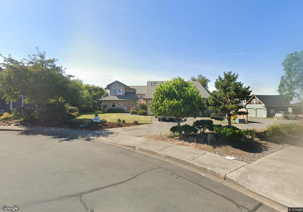
This home is located at 2605 NW Astor St, Camas, WA 98607 and is currently estimated at $1,065,786, approximately $290 per square foot. 2605 NW Astor St is a home located in Clark County with nearby schools including Dorothy Fox Elementary School, Skyridge Middle School, and Camas High School.
Ownership History
Date
Name
Owned For
Owner Type
Purchase Details
Closed on
Dec 14, 2022
Sold by
Wright Kathryn C and Wright Darryl C
Bought by
Darryl C Wright And Kathryn C Wright Revocabl
Current Estimated Value
Purchase Details
Closed on
Sep 1, 2017
Sold by
Wright Darryl C and Wright Kathryn C
Bought by
Wright Kathryn C and Wright Darryl C
Home Financials for this Owner
Home Financials are based on the most recent Mortgage that was taken out on this home.
Original Mortgage
$405,000
Interest Rate
3.9%
Mortgage Type
New Conventional
Purchase Details
Closed on
Jun 15, 2015
Sold by
Wright Darryl C and Wright Kathryn C
Bought by
Wright Darryl C and Revoc Kathryn C Wright
Create a Home Valuation Report for This Property
The Home Valuation Report is an in-depth analysis detailing your home's value as well as a comparison with similar homes in the area
Home Values in the Area
Average Home Value in this Area
Purchase History
| Date | Buyer | Sale Price | Title Company |
|---|---|---|---|
| Darryl C Wright And Kathryn C Wright Revocabl | -- | -- | |
| Wright Kathryn C | -- | Wfg Natl Title Co Of Clark C | |
| Wright Darryl C | -- | None Available |
Source: Public Records
Mortgage History
| Date | Status | Borrower | Loan Amount |
|---|---|---|---|
| Previous Owner | Wright Kathryn C | $405,000 |
Source: Public Records
Tax History Compared to Growth
Tax History
| Year | Tax Paid | Tax Assessment Tax Assessment Total Assessment is a certain percentage of the fair market value that is determined by local assessors to be the total taxable value of land and additions on the property. | Land | Improvement |
|---|---|---|---|---|
| 2025 | $8,700 | $854,193 | $170,000 | $684,193 |
| 2024 | $8,268 | $912,997 | $222,700 | $690,297 |
| 2023 | $8,329 | $933,028 | $224,400 | $708,628 |
| 2022 | $7,984 | $893,709 | $212,500 | $681,209 |
| 2021 | $8,049 | $716,075 | $170,000 | $546,075 |
| 2020 | $8,394 | $668,963 | $170,000 | $498,963 |
| 2019 | $7,701 | $646,960 | $170,000 | $476,960 |
| 2018 | $8,095 | $632,210 | $0 | $0 |
| 2017 | $7,383 | $558,606 | $0 | $0 |
| 2016 | $3,421 | $554,834 | $0 | $0 |
| 2015 | $6,803 | $511,676 | $0 | $0 |
| 2014 | -- | $479,676 | $0 | $0 |
| 2013 | -- | $446,094 | $0 | $0 |
Source: Public Records
Map
Nearby Homes
- 2609 NW Cascade St
- 2316 NW 26th Ave
- 2711 NW 28th Cir
- 3015 NW Vanguard Place
- 2720 NW 30th Cir
- 2107 NW Douglas St
- 2012 NW Willow Dr
- 2955 NW Dahlia Dr
- 1911 NW Astor Ct
- 14 NW Hood St
- 15 NW Hood St
- 3 NW Hood St
- 2534 NW 16th Ave
- 2546 NW 16th Ave
- 2458 NW 16th Ave
- 3313 NW Sierra Dr
- 3133 NW 18th Ave
- 0 NW Julia St
- 3113 NW Pacific Rim Dr
- 3367 NW 31st Cir
- 6 NW Astor St
- 31 NW Astor St
- 5 NW Astor St
- 32 NW Astor St
- 0 NW Astor St
- 2615 NW Astor St
- 2507 NW 25th Ave
- 2415 NW 26th Ave
- 2443 NW 25th Ave
- 2616 NW Cascade St
- 2412 NW 26th Ave
- 2620 NW Cascade St
- 2401 NW 26th Ave
- 2641 NW Sunset Ct
- 2520 NW Cascade St
- 2440 NW 25th Ave
- 2706 NW Cascade St
- 2350 NW 26th Ave
- 2510 NW 25th Ave
- 2711 NW Sunset Ct