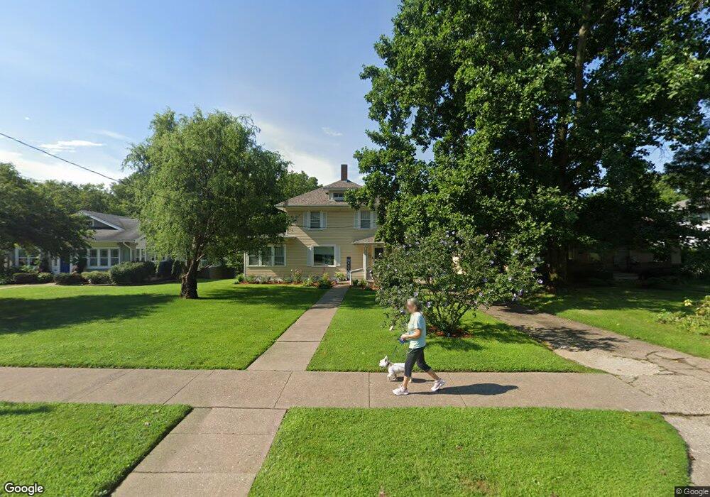
2608 Mulberry Ave Muscatine, IA 52761
Estimated Value: $158,000 - $184,702
3
Beds
1
Bath
1,744
Sq Ft
$100/Sq Ft
Est. Value
About This Home
This home is located at 2608 Mulberry Ave, Muscatine, IA 52761 and is currently estimated at $173,926, approximately $99 per square foot. 2608 Mulberry Ave is a home located in Muscatine County with nearby schools including Grant Elementary School, Central Middle School, and Muscatine High School.
Ownership History
Date
Name
Owned For
Owner Type
Purchase Details
Closed on
Dec 22, 2017
Sold by
First National Bank Of Muscatine
Bought by
Kemper Amanda J
Current Estimated Value
Home Financials for this Owner
Home Financials are based on the most recent Mortgage that was taken out on this home.
Original Mortgage
$82,450
Interest Rate
3.95%
Mortgage Type
Future Advance Clause Open End Mortgage
Purchase Details
Closed on
Mar 3, 2011
Sold by
Olson Ranald E
Bought by
Nichols Troy A
Home Financials for this Owner
Home Financials are based on the most recent Mortgage that was taken out on this home.
Original Mortgage
$86,000
Interest Rate
4.88%
Mortgage Type
New Conventional
Create a Home Valuation Report for This Property
The Home Valuation Report is an in-depth analysis detailing your home's value as well as a comparison with similar homes in the area
Home Values in the Area
Average Home Value in this Area
Purchase History
| Date | Buyer | Sale Price | Title Company |
|---|---|---|---|
| Kemper Amanda J | $97,000 | None Available | |
| Nichols Troy A | $107,500 | None Available |
Source: Public Records
Mortgage History
| Date | Status | Borrower | Loan Amount |
|---|---|---|---|
| Closed | Kemper Amanda J | $82,450 | |
| Previous Owner | Nichols Troy A | $86,000 |
Source: Public Records
Tax History Compared to Growth
Tax History
| Year | Tax Paid | Tax Assessment Tax Assessment Total Assessment is a certain percentage of the fair market value that is determined by local assessors to be the total taxable value of land and additions on the property. | Land | Improvement |
|---|---|---|---|---|
| 2025 | $2,370 | $141,800 | $46,650 | $95,150 |
| 2024 | $2,370 | $140,980 | $46,650 | $94,330 |
| 2023 | $2,124 | $132,500 | $46,651 | $85,849 |
| 2022 | $2,104 | $118,990 | $44,010 | $74,980 |
| 2021 | $2,104 | $112,100 | $44,010 | $68,090 |
| 2020 | $2,204 | $113,700 | $44,010 | $69,690 |
| 2019 | $2,240 | $109,920 | $0 | $0 |
| 2018 | $3,002 | $146,500 | $0 | $0 |
| 2017 | $3,002 | $146,500 | $0 | $0 |
| 2016 | $3,116 | $146,500 | $0 | $0 |
| 2015 | $3,116 | $136,280 | $0 | $0 |
| 2014 | $2,904 | $136,280 | $0 | $0 |
Source: Public Records
Map
Nearby Homes
- 3 Wilson Dr
- 35 Colony Dr
- 108 Middle Rd
- 297 Burnside Ave
- 205 Amherst Ave
- 709 Leroy St
- 606 Leroy St
- 1014 Wier St
- 1807 Mulberry Ave
- 310 Wood Creek Ln
- 2126 Bidwell Rd
- 1251 Vista Ct
- 2020 Bidwell Rd
- 603 Aspen Trail
- 601 Aspen Trail
- 898 Leroy St
- 0 Aspen Trail
- 602 W Fulliam Ave
- 2618 Anna Elizabeth
- 2612 Anna Elizabeth
- 2604 Mulberry Ave
- 2616 Mulberry Ave
- 2600 Mulberry Ave
- 2620 Mulberry Ave
- 2520 Mulberry Ave
- 0 Mulberry Ave
- 2601 Mulberry Ave
- 2704 Mulberry Ave
- 2518 Mulberry Ave
- 2708 Mulberry Ave
- 2516 Mulberry Ave
- 406 Hogan Ct
- 2712 Mulberry Ave
- 2512 Mulberry Ave
- 11 Colony Dr
- 2707 Mulberry Ave
- 2508 Mulberry Ave
- 2716 Mulberry Ave
- 401 Hogan Ct
- 7 Colony Dr