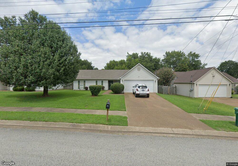
261 Forest Pointe Dr Jackson, TN 38305
Estimated Value: $181,000 - $233,000
Studio
2
Baths
1,239
Sq Ft
$161/Sq Ft
Est. Value
About This Home
This home is located at 261 Forest Pointe Dr, Jackson, TN 38305 and is currently estimated at $198,950, approximately $160 per square foot. 261 Forest Pointe Dr is a home located in Madison County with nearby schools including Pope School, Northeast Middle School, and North Side High School.
Ownership History
Date
Name
Owned For
Owner Type
Purchase Details
Closed on
Oct 15, 2002
Sold by
Sec Of Hud
Bought by
Brent Cooper
Current Estimated Value
Purchase Details
Closed on
Jun 5, 2002
Sold by
Bank Of America
Bought by
Sec Of Hud
Purchase Details
Closed on
May 15, 2002
Sold by
Wallis Edwin E Jr Sub Tr
Bought by
Bank Of America
Purchase Details
Closed on
Mar 3, 2002
Purchase Details
Closed on
Sep 8, 1997
Sold by
Hill Felbert L
Bought by
Hill Peggy A
Purchase Details
Closed on
Aug 19, 1997
Bought by
Hill Felbert L
Purchase Details
Closed on
Aug 12, 1997
Sold by
Humboldt Road Partners
Bought by
Winberry Construction
Create a Home Valuation Report for This Property
The Home Valuation Report is an in-depth analysis detailing your home's value as well as a comparison with similar homes in the area
Purchase History
| Date | Buyer | Sale Price | Title Company |
|---|---|---|---|
| Brent Cooper | $70,500 | -- | |
| Sec Of Hud | -- | -- | |
| Bank Of America | $83,224 | -- | |
| -- | $83,200 | -- | |
| Hill Peggy A | -- | -- | |
| Hill Felbert L | $70,600 | -- | |
| Winberry Construction | $13,500 | -- |
Source: Public Records
Tax History
| Year | Tax Paid | Tax Assessment Tax Assessment Total Assessment is a certain percentage of the fair market value that is determined by local assessors to be the total taxable value of land and additions on the property. | Land | Improvement |
|---|---|---|---|---|
| 2025 | $684 | $36,500 | $6,250 | $30,250 |
| 2024 | $684 | $36,500 | $6,250 | $30,250 |
| 2022 | $1,272 | $36,500 | $6,250 | $30,250 |
| 2021 | $892 | $20,700 | $3,750 | $16,950 |
| 2020 | $892 | $20,700 | $3,750 | $16,950 |
| 2019 | $892 | $20,700 | $3,750 | $16,950 |
| 2018 | $892 | $20,700 | $3,750 | $16,950 |
| 2017 | $897 | $20,325 | $3,750 | $16,575 |
| 2016 | $836 | $20,325 | $3,750 | $16,575 |
| 2015 | $836 | $20,325 | $3,750 | $16,575 |
| 2014 | $823 | $20,025 | $3,750 | $16,275 |
Source: Public Records
Map
Nearby Homes
- 72 Nolan Cove
- 44 Nolan Cove
- 71 Nolan Cove
- 0 Old Humboldt Rd
- 24 Richfield Cove
- 15 Richfield Cove
- 221 Greenhill Dr
- 57 Wakefield Cove
- 9 Dayton Cove
- 39 Kings Gate Cove
- 416 Fairway Blvd
- 0 - N Highway 45 Bypass Frontage
- 00 Sterling Farm Dr
- 0 - A Sterling Farm Dr
- 410 Fairway Blvd
- 59 Livingston Way
- 87 Garrison Dr
- 122 Garrison Dr
- 116 Garrison Dr
- 292 Copper Creek Dr
- 269 Forest Pointe Dr
- 253 Forest Pointe Dr
- 277 Forest Pointe Dr
- 245 Forest Pointe Dr
- 11 Morning Dew Cove
- 1037 Old Humboldt Rd
- 237 Forest Pointe Dr
- 10 Turtle Creek Dr
- 19 Morning Dew Cove
- 287 Forest Pointe Dr
- 12 Morning Dew Cove
- 18 Turtle Creek Dr
- 20 Morning Dew Cove
- 229 Forest Pointe Dr
- 1043 Old Humboldt Rd
- 27 Morning Dew Cove
- 26 Turtle Creek Dr
- 28 Morning Dew Cove
- 221 Forest Pointe Dr
- 9 Turtle Creek Dr
Your Personal Tour Guide
Ask me questions while you tour the home.