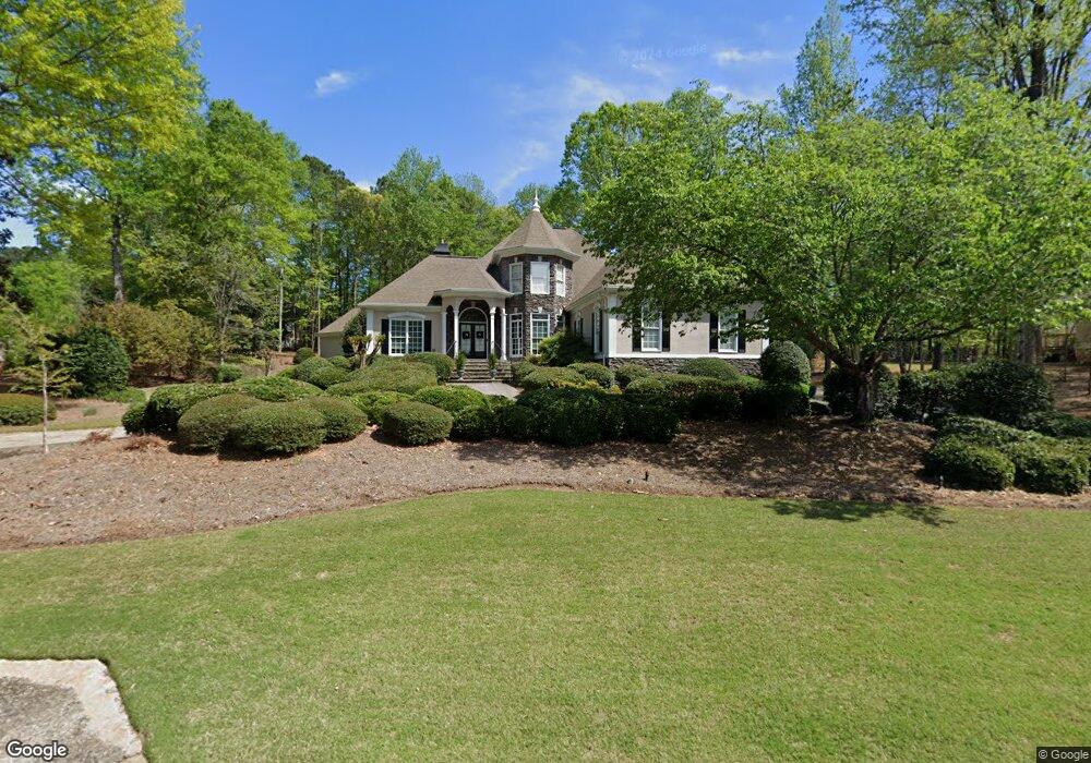
261 Smokerise Trace Peachtree City, GA 30269
Estimated Value: $924,000 - $1,103,000
--
Bed
--
Bath
3,332
Sq Ft
$311/Sq Ft
Est. Value
About This Home
This home is located at 261 Smokerise Trace, Peachtree City, GA 30269 and is currently estimated at $1,036,844, approximately $311 per square foot. 261 Smokerise Trace is a home located in Fayette County with nearby schools including Crabapple Lane Elementary School, Booth Middle School, and McIntosh High School.
Ownership History
Date
Name
Owned For
Owner Type
Purchase Details
Closed on
Nov 21, 2022
Sold by
Daniel Barry E
Bought by
Rosewood West Lanier I Llc
Current Estimated Value
Purchase Details
Closed on
Oct 29, 2022
Sold by
Trust U/W J C Daniel
Bought by
Chapman Mallory M
Purchase Details
Closed on
Jun 4, 1999
Sold by
Teel Teel J and Teel Peggy
Bought by
Daniel Barry E and Daniel Shirley A
Home Financials for this Owner
Home Financials are based on the most recent Mortgage that was taken out on this home.
Original Mortgage
$400,000
Interest Rate
7.04%
Mortgage Type
New Conventional
Purchase Details
Closed on
Jan 10, 1997
Sold by
Southern Comfort Classic Homes
Bought by
Teel J Richard Peggy
Create a Home Valuation Report for This Property
The Home Valuation Report is an in-depth analysis detailing your home's value as well as a comparison with similar homes in the area
Home Values in the Area
Average Home Value in this Area
Purchase History
| Date | Buyer | Sale Price | Title Company |
|---|---|---|---|
| Rosewood West Lanier I Llc | $475,000 | -- | |
| Chapman Mallory M | -- | -- | |
| Chapman Mallory M | -- | None Listed On Document | |
| Daniel Barry E | $725,000 | -- | |
| Teel J Richard Peggy | $429,000 | -- |
Source: Public Records
Mortgage History
| Date | Status | Borrower | Loan Amount |
|---|---|---|---|
| Previous Owner | Daniel Barry E | $400,000 | |
| Closed | Teel J Richard Peggy | $0 |
Source: Public Records
Tax History Compared to Growth
Tax History
| Year | Tax Paid | Tax Assessment Tax Assessment Total Assessment is a certain percentage of the fair market value that is determined by local assessors to be the total taxable value of land and additions on the property. | Land | Improvement |
|---|---|---|---|---|
| 2024 | $6,094 | $449,280 | $70,000 | $379,280 |
| 2023 | $5,672 | $431,320 | $70,000 | $361,320 |
| 2022 | $5,952 | $358,600 | $58,000 | $300,600 |
| 2021 | $5,487 | $268,640 | $58,000 | $210,640 |
| 2020 | $5,877 | $282,480 | $58,000 | $224,480 |
| 2019 | $8,297 | $267,800 | $58,000 | $209,800 |
| 2018 | $8,653 | $274,760 | $58,000 | $216,760 |
| 2017 | $8,479 | $267,520 | $58,000 | $209,520 |
| 2016 | $8,049 | $243,720 | $58,000 | $185,720 |
| 2015 | $8,489 | $252,740 | $66,500 | $186,240 |
| 2014 | $8,231 | $240,940 | $66,500 | $174,440 |
| 2013 | -- | $240,940 | $0 | $0 |
Source: Public Records
Map
Nearby Homes
- 806 Smokey Way
- 602 Embassy Ct
- 230 Smokerise Trace
- 100 Smokerise Trace
- 104 Hidden Springs Ln
- 504 Telfair Park
- 110 Twin Branch Walk
- 1133 Astoria Ln
- 301 Abercorn Square
- 125 Seymour Place
- 115 Seymour Place
- 117 N Cove Dr
- 109 Peninsula Dr
- 110 Old Mill Crossing
- 216 Redding Ridge
- 101 Parkway Dr
- 240 Old Plantation Way
- 155 Aspen Way
- 208 Regester Way
- 210 Regester Way
- 403 Loyd Rd
- 401 Loyd Rd
- 257 Smokerise Trace
- 802 Smokey Way
- 258 Smokerise Trace
- 405 Loyd Rd
- 260 Smokerise Trace
- 901 Emerald Ct
- 256 Smokerise Trace
- 804 Smokey Way
- 265 Smokerise Trace
- 255 Smokerise Trace
- 402 Loyd Rd
- 407 Loyd Rd
- 264 Smokerise Trace
- 254 Smokerise Trace
- 262 Smokerise Trace
- 404 Loyd Rd
- 807 Smokey Way
- 409 Loyd Rd