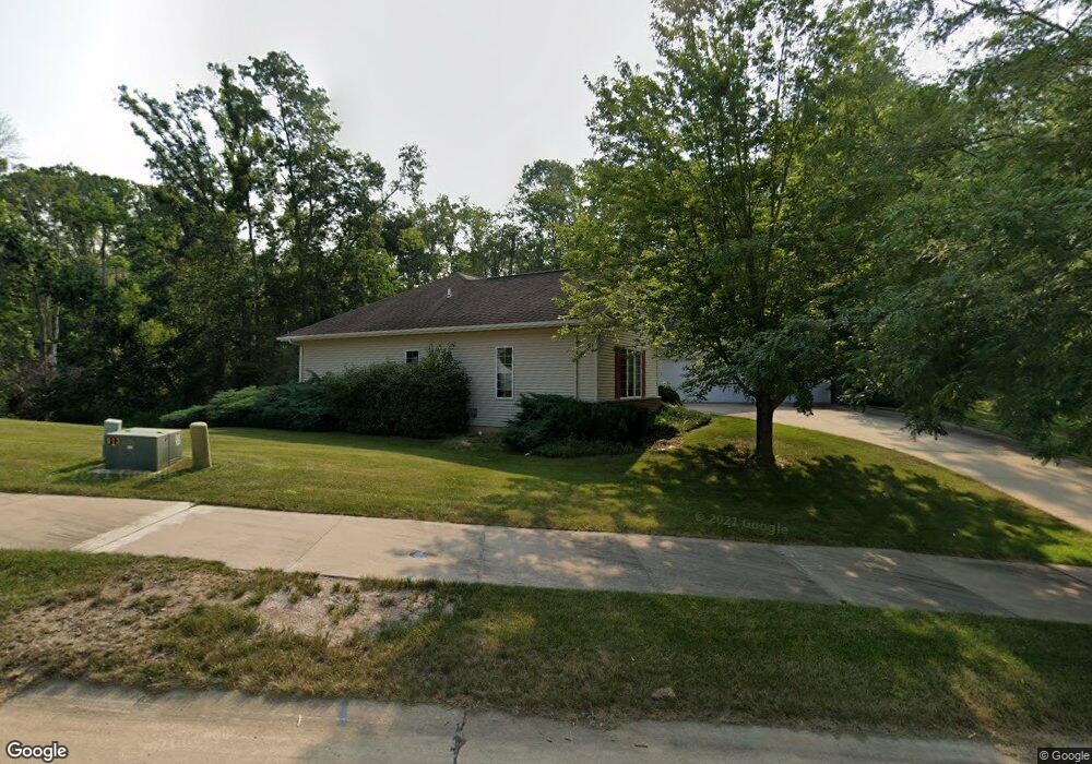
2610 Long Bluff Rd NE Cedar Rapids, IA 52402
Estimated Value: $509,000 - $546,000
4
Beds
4
Baths
2,409
Sq Ft
$219/Sq Ft
Est. Value
About This Home
This home is located at 2610 Long Bluff Rd NE, Cedar Rapids, IA 52402 and is currently estimated at $526,539, approximately $218 per square foot. 2610 Long Bluff Rd NE is a home located in Linn County with nearby schools including Pierce Elementary School, Franklin Middle School, and John F. Kennedy High School.
Ownership History
Date
Name
Owned For
Owner Type
Purchase Details
Closed on
Oct 17, 2024
Sold by
Wasik Denise O
Bought by
Denise Oak Wasik Revocable Trust and Wasik
Current Estimated Value
Purchase Details
Closed on
Jan 30, 2003
Sold by
Primahne Associates
Bought by
Wasik Ralph W and Wasik Denise O
Purchase Details
Closed on
Jan 13, 2003
Sold by
Primahne Associates Llp
Bought by
Wasik Ralph W and Wasik Denise O
Create a Home Valuation Report for This Property
The Home Valuation Report is an in-depth analysis detailing your home's value as well as a comparison with similar homes in the area
Purchase History
| Date | Buyer | Sale Price | Title Company |
|---|---|---|---|
| Denise Oak Wasik Revocable Trust | -- | None Listed On Document | |
| Wasik Ralph W | -- | -- | |
| Wasik Ralph W | $69,500 | -- |
Source: Public Records
Tax History
| Year | Tax Paid | Tax Assessment Tax Assessment Total Assessment is a certain percentage of the fair market value that is determined by local assessors to be the total taxable value of land and additions on the property. | Land | Improvement |
|---|---|---|---|---|
| 2025 | $7,806 | $509,800 | $92,800 | $417,000 |
| 2024 | $9,194 | $458,600 | $92,800 | $365,800 |
| 2023 | $9,194 | $458,600 | $92,800 | $365,800 |
| 2022 | $8,736 | $444,800 | $92,800 | $352,000 |
| 2021 | $9,298 | $430,700 | $91,600 | $339,100 |
| 2020 | $9,298 | $430,000 | $91,600 | $338,400 |
| 2019 | $8,538 | $404,600 | $91,600 | $313,000 |
| 2018 | $8,298 | $404,600 | $91,600 | $313,000 |
| 2017 | $9,197 | $421,300 | $91,600 | $329,700 |
| 2016 | $9,197 | $432,700 | $91,600 | $341,100 |
| 2015 | $9,059 | $425,738 | $91,550 | $334,188 |
| 2014 | $8,874 | $425,738 | $91,550 | $334,188 |
| 2013 | $8,680 | $425,738 | $91,550 | $334,188 |
Source: Public Records
Map
Nearby Homes
- 2726 Seneca Ct NE
- 122 Lakota Ct NE
- 1549 Matterhorn Dr NE
- 1585 Matterhorn Dr NE
- 1568 Matterhorn Dr NE Unit A
- 2237 Tranquil Ct NW
- 618 J Ave NE
- 1718 Applewood Place NE
- 1724 Pikes Peak Ct NE Unit C
- 1759 Applewood Place NE
- 2445 Glass Rd NE
- 3425 Sycamore Ct NE
- 2048 20th St NW
- 1871 Ellis Blvd NW Unit 202
- 1871 Ellis Blvd NW Unit 205
- 2603 Falcon Dr NE
- 3608 Foxborough Terrace NE Unit B
- 3824 Wenig Rd NE
- 2226 Sierra Cir NE
- 4113 Lexington Ct NE Unit C
- 200 McKinsie Ct NE
- 2530 Long Bluff Rd NE
- 210 McKinsie Ct NE
- 2655 Long Bluff Rd NE
- 2500 Long Bluff Rd NE
- 222 McKinsie Ct NE
- 215 McKinsie Ct NE
- 234 McKinsie Ct NE
- 223 McKinsie Ct NE
- 231 McKinsie Ct NE
- 242 McKinsie Ct NE
- 205 McKinsie Ct NE
- 239 McKinsie Ct NE
- 2708 Long Bluff Rd NE
- 300 McKinsie Ct NE
- 247 McKinsie Ct NE
- 2710 Seneca Ct NE
- 2716 Long Bluff Rd NE
- 305 McKinsie Ct NE
- 2721 Seneca Ct NE
Your Personal Tour Guide
Ask me questions while you tour the home.