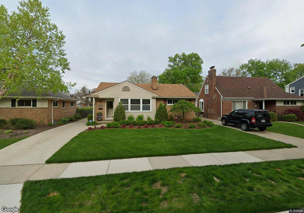
2611 Woodland Ave Royal Oak, MI 48073
Estimated Value: $345,642 - $458,000
3
Beds
3
Baths
1,062
Sq Ft
$381/Sq Ft
Est. Value
About This Home
This home is located at 2611 Woodland Ave, Royal Oak, MI 48073 and is currently estimated at $404,911, approximately $381 per square foot. 2611 Woodland Ave is a home located in Oakland County with nearby schools including Addams Elementary, Royal Oak Middle School, and Royal Oak High School.
Ownership History
Date
Name
Owned For
Owner Type
Purchase Details
Closed on
Oct 12, 2016
Sold by
St Michael Phyllis and St Michael Phyllis J
Bought by
St Michael Phyllis J and St Michael Phyllis J
Current Estimated Value
Purchase Details
Closed on
May 18, 2011
Sold by
Duross Robert G and Duross Kathleen E
Bought by
St Michael Phyllis
Purchase Details
Closed on
Apr 12, 2001
Sold by
Mitchell James M
Bought by
Duross Robert G
Purchase Details
Closed on
Sep 28, 1994
Sold by
Est Albert Mitchell
Bought by
Mitchell James M and Mitchell Carolyn G
Home Financials for this Owner
Home Financials are based on the most recent Mortgage that was taken out on this home.
Original Mortgage
$80,250
Interest Rate
8.64%
Mortgage Type
New Conventional
Create a Home Valuation Report for This Property
The Home Valuation Report is an in-depth analysis detailing your home's value as well as a comparison with similar homes in the area
Home Values in the Area
Average Home Value in this Area
Purchase History
| Date | Buyer | Sale Price | Title Company |
|---|---|---|---|
| St Michael Phyllis J | -- | None Available | |
| St Michael Phyllis | $156,250 | Capital Title Ins Agency | |
| Duross Robert G | $203,000 | -- | |
| Mitchell James M | $89,200 | -- |
Source: Public Records
Mortgage History
| Date | Status | Borrower | Loan Amount |
|---|---|---|---|
| Previous Owner | Mitchell James M | $80,250 |
Source: Public Records
Tax History Compared to Growth
Tax History
| Year | Tax Paid | Tax Assessment Tax Assessment Total Assessment is a certain percentage of the fair market value that is determined by local assessors to be the total taxable value of land and additions on the property. | Land | Improvement |
|---|---|---|---|---|
| 2024 | $2,746 | $130,600 | $0 | $0 |
| 2022 | $3,245 | $117,750 | $0 | $0 |
| 2020 | $2,668 | $106,610 | $0 | $0 |
| 2018 | $3,245 | $100,620 | $0 | $0 |
| 2017 | $3,119 | $100,620 | $0 | $0 |
| 2015 | -- | $89,720 | $0 | $0 |
| 2014 | -- | $82,810 | $0 | $0 |
| 2011 | -- | $72,580 | $0 | $0 |
Source: Public Records
Map
Nearby Homes
- 2606 Benjamin Ave
- 2916 Clawson Ave
- 2714 Glenview Ave
- 2403 Clawson Ave
- 2303 Linwood Ave
- 2804 Shenandoah Dr
- 2806 Shenandoah Dr
- 2925 Benjamin Ave
- 3100 Linwood Ave Unit B, 28
- 2602 Trafford Rd
- 2125 Clawson Ave Unit 107
- 2125 Clawson Ave Unit 207
- 2121 Clawson Ave Unit D, 205
- 2814 Crooks Rd
- 2438 Evergreen Dr
- 2614 Essex St
- 1433 Royal Ave
- 1915 Northwood Blvd
- 3402 Woodland Ave
- 2826 Bembridge Rd
- 2617 Woodland Ave
- 2607 Woodland Ave
- 2621 Woodland Ave
- 2603 Woodland Ave
- 2610 Linwood Ave
- 2616 Linwood Ave
- 2606 Linwood Ave
- 2703 Woodland Ave
- 2527 Woodland Ave
- 2620 Linwood Ave
- 2600 Linwood Ave
- 2606 Woodland Ave
- 2616 Woodland Ave
- 2702 Linwood Ave
- 2526 Linwood Ave
- 2707 Woodland Ave
- 2523 Woodland Ave
- 2600 Woodland Ave
- 2620 Woodland Ave
- 2526 Woodland Ave