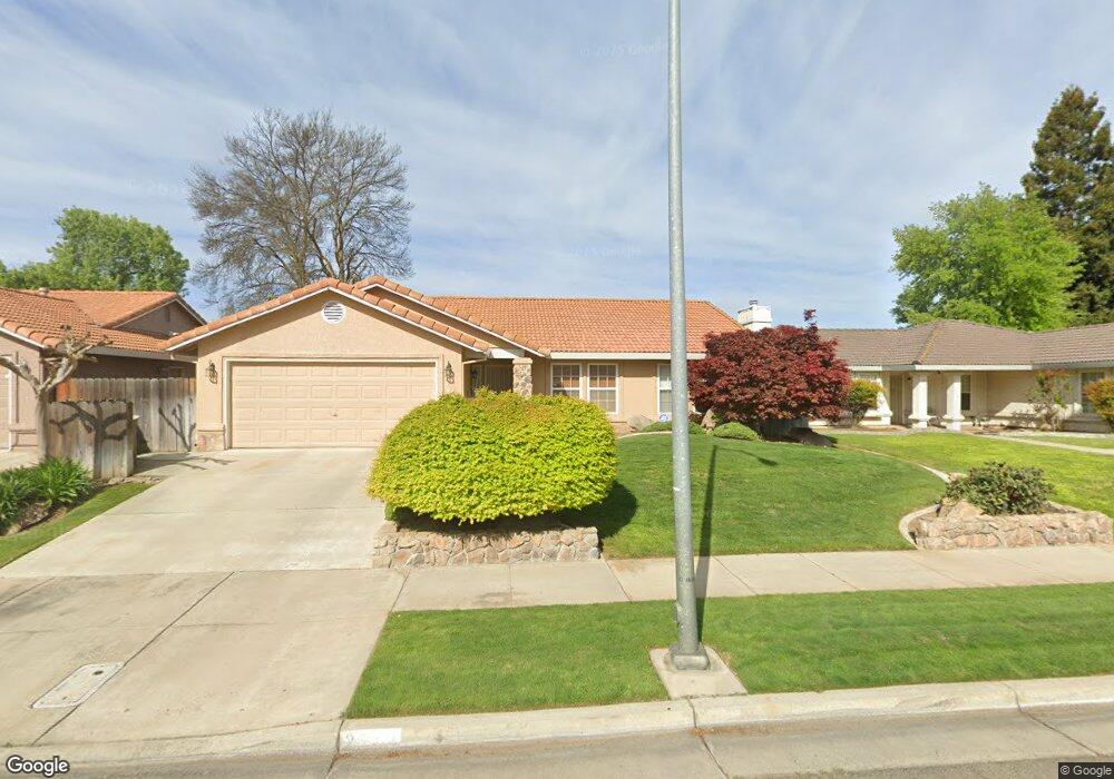
2613 Stonybrook Ave Merced, CA 95348
Estimated Value: $328,000 - $359,000
3
Beds
2
Baths
1,287
Sq Ft
$268/Sq Ft
Est. Value
About This Home
This home is located at 2613 Stonybrook Ave, Merced, CA 95348 and is currently estimated at $345,300, approximately $268 per square foot. 2613 Stonybrook Ave is a home located in Merced County with nearby schools including Luther Burbank Elementary School, Tenaya Middle School, and Merced High School.
Ownership History
Date
Name
Owned For
Owner Type
Purchase Details
Closed on
Oct 7, 1998
Sold by
Sanchez George and Sanchez Marion
Bought by
Longo Roger V and Longo Tina
Current Estimated Value
Home Financials for this Owner
Home Financials are based on the most recent Mortgage that was taken out on this home.
Original Mortgage
$102,609
Outstanding Balance
$21,885
Interest Rate
6.6%
Estimated Equity
$323,415
Create a Home Valuation Report for This Property
The Home Valuation Report is an in-depth analysis detailing your home's value as well as a comparison with similar homes in the area
Purchase History
| Date | Buyer | Sale Price | Title Company |
|---|---|---|---|
| Longo Roger V | $104,000 | Chicago Title Co |
Source: Public Records
Mortgage History
| Date | Status | Borrower | Loan Amount |
|---|---|---|---|
| Open | Longo Roger V | $102,609 |
Source: Public Records
Tax History
| Year | Tax Paid | Tax Assessment Tax Assessment Total Assessment is a certain percentage of the fair market value that is determined by local assessors to be the total taxable value of land and additions on the property. | Land | Improvement |
|---|---|---|---|---|
| 2025 | $1,723 | $163,014 | $47,020 | $115,994 |
| 2024 | $1,723 | $159,819 | $46,099 | $113,720 |
| 2023 | $1,699 | $156,687 | $45,196 | $111,491 |
| 2022 | $1,745 | $153,615 | $44,310 | $109,305 |
| 2021 | $1,730 | $150,604 | $43,442 | $107,162 |
| 2020 | $1,671 | $149,061 | $42,997 | $106,064 |
| 2019 | $1,650 | $146,139 | $42,154 | $103,985 |
| 2018 | $1,505 | $143,275 | $41,328 | $101,947 |
| 2017 | $1,549 | $140,467 | $40,518 | $99,949 |
| 2016 | $1,524 | $137,714 | $39,724 | $97,990 |
| 2015 | $1,492 | $135,647 | $39,128 | $96,519 |
| 2014 | $1,456 | $132,991 | $38,362 | $94,629 |
Source: Public Records
Map
Nearby Homes
- 2500 N State Highway 59 Unit 36
- 2500 N State Highway 59 Unit 278
- 2500 N State Highway 59 Unit 239
- 2500 N State Highway 59 Unit 18
- 2500 N State Highway 59
- 1963 Shadowbrook Dr
- 1541 W North Bear Creek Dr
- 1973 Shadowbrook Dr
- 1648 W North Bear Creek Dr
- 1646 W North Bear Creek Dr
- 1664 W North Bear Creek Dr Unit 5
- 1656 W North Bear Creek Dr Unit 9
- 2790 N State Highway 59
- 1441 W 20th St
- 1482 Autry Way
- 1438 W 19th St
- 1463 W 25th St
- 3157 Juneau Ct
- 1274 Devonwood Dr
- 1145 W 22nd St
- 2601 Stonybrook Ave
- 2625 Stonybrook Ave
- 2600 Stonybrook Ave
- 2589 Stonybrook Ave
- 2637 Stonybrook Ave
- 2612 Stonybrook Ave
- 2624 Stonybrook Ave
- 2577 Stonybrook Ave
- 2649 Stonybrook Ave
- 2636 Stonybrook Ave
- 2588 Stonybrook Ave
- 2565 Stonybrook Ave
- 2661 Stonybrook Ave
- 1884 Creekside Dr
- 2576 Stonybrook Ave
- 2611 Silver Creek Ct
- 2673 Stonybrook Ave
- 2553 Stonybrook Ave
- 2599 Silver Creek Ct
- 1872 Creekside Dr
Your Personal Tour Guide
Ask me questions while you tour the home.