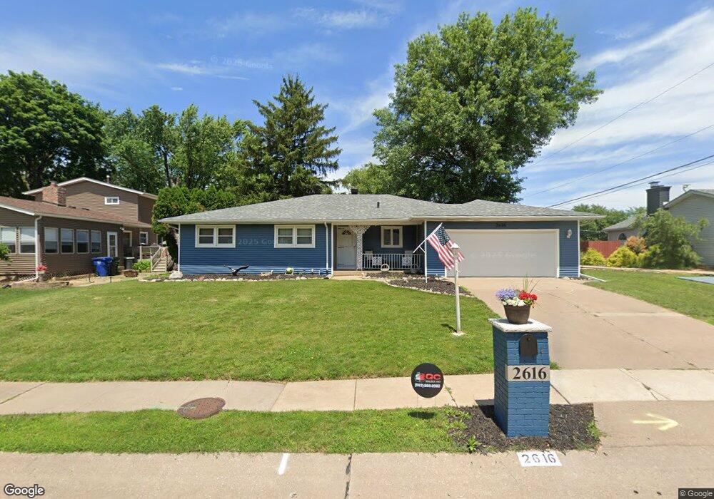
2616 E 39th St Davenport, IA 52807
North Side NeighborhoodEstimated Value: $241,000 - $267,000
3
Beds
2
Baths
1,710
Sq Ft
$152/Sq Ft
Est. Value
About This Home
This home is located at 2616 E 39th St, Davenport, IA 52807 and is currently estimated at $260,193, approximately $152 per square foot. 2616 E 39th St is a home located in Scott County with nearby schools including Eisenhower Elementary School, Sudlow Intermediate School, and Central High School.
Ownership History
Date
Name
Owned For
Owner Type
Purchase Details
Closed on
Sep 19, 2021
Sold by
Gunnar Llc
Bought by
First Financial Group Lc
Current Estimated Value
Purchase Details
Closed on
Apr 6, 2017
Sold by
Rensberger Ruth J
Bought by
Gunnar Llc
Home Financials for this Owner
Home Financials are based on the most recent Mortgage that was taken out on this home.
Original Mortgage
$155,000
Interest Rate
4.21%
Mortgage Type
New Conventional
Create a Home Valuation Report for This Property
The Home Valuation Report is an in-depth analysis detailing your home's value as well as a comparison with similar homes in the area
Home Values in the Area
Average Home Value in this Area
Purchase History
| Date | Buyer | Sale Price | Title Company |
|---|---|---|---|
| First Financial Group Lc | $148,000 | None Available | |
| Gunnar Llc | $155,000 | None Available |
Source: Public Records
Mortgage History
| Date | Status | Borrower | Loan Amount |
|---|---|---|---|
| Previous Owner | Gunnar Llc | $155,000 |
Source: Public Records
Tax History
| Year | Tax Paid | Tax Assessment Tax Assessment Total Assessment is a certain percentage of the fair market value that is determined by local assessors to be the total taxable value of land and additions on the property. | Land | Improvement |
|---|---|---|---|---|
| 2025 | $4,724 | $279,050 | $44,240 | $234,810 |
| 2024 | $4,610 | $264,370 | $44,240 | $220,130 |
| 2023 | $4,604 | $264,370 | $44,240 | $220,130 |
| 2022 | $4,464 | $215,580 | $40,390 | $175,190 |
| 2021 | $4,464 | $208,030 | $40,390 | $167,640 |
| 2020 | $4,224 | $194,440 | $40,390 | $154,050 |
| 2019 | $4,294 | $191,420 | $40,390 | $151,030 |
| 2018 | $4,004 | $191,420 | $40,390 | $151,030 |
| 2017 | $3,878 | $182,280 | $40,390 | $141,890 |
| 2016 | $3,728 | $182,280 | $0 | $0 |
| 2015 | $3,728 | $179,790 | $0 | $0 |
| 2014 | $3,726 | $179,790 | $0 | $0 |
| 2013 | $3,656 | $0 | $0 | $0 |
| 2012 | -- | $166,580 | $39,120 | $127,460 |
Source: Public Records
Map
Nearby Homes
- 3730 Kenwood Ave
- 2919 E 44th Ct
- 3818 Belle Ave
- 4709 Pheasant Creek Ave
- 4320 Belle Ave
- 4732 Pheasant Creek Ave
- 2515 E George Washington Blvd
- 0 Eastern Unit MRDQC4247043
- 5002 Fairhaven Rd
- 0 E 53rd St Unit Lot 4
- 1227 E Kimberly Rd Unit 5A
- 280 Mason Dr
- 237 Mason Dr
- 0 Golden Valley Dr
- 2704 Magnolia Dr
- 2613 Hawthorne Dr Unit 2613
- 3618 Magnolia Ct
- 3750 Market Square Cir
- 2814 Hillside Ct
- 1006 Hillside Dr
- 2624 E 39th St
- 3907 Lorton Ave
- 2632 E 39th St
- 2601 E 40th St
- 2603 E 40th St
- 2625 E 39th St
- 3821 Lorton Ave
- 2638 E 39th St
- 3910 Lorton Ave
- 3904 Lorton Ave
- 3828 Kenwood Ave
- 3824 Lorton Ave
- 2511 E 40th St
- 3811 Lorton Ave
- 3816 Lorton Ave
- 3820 Kenwood Ave
- 3833 Kenwood Ave
- 3745 Lorton Ave
- 3823 Woodland Ct
- 2602 E 40th St
Your Personal Tour Guide
Ask me questions while you tour the home.