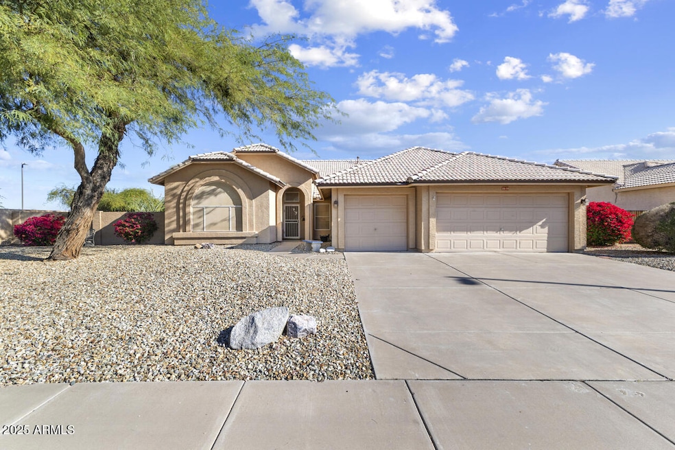
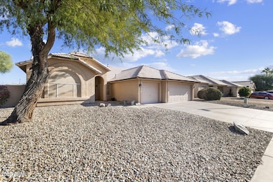
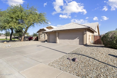
2619 N 133rd Ave Goodyear, AZ 85395
Palm Valley NeighborhoodEstimated payment $3,356/month
Highlights
- Golf Course Community
- Private Pool
- Corner Lot
- Palm Valley Elementary School Rated A-
- Vaulted Ceiling
- Private Yard
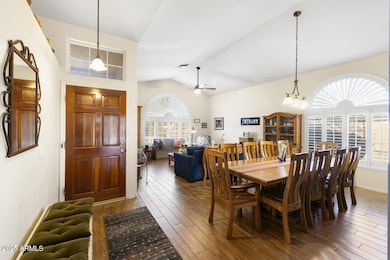
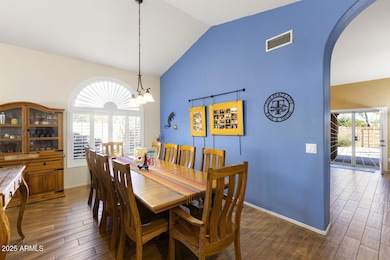
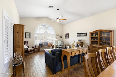
About This Home
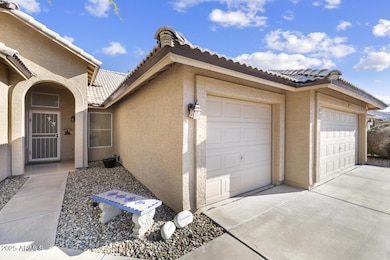
Rare Find in Palm Valley! This 4 Bd/2Bath home and 3 car garage is situated on a HUGE corner lot with private pool. No 2 story homes behind this home which allows for total privacy. As you enter the home you will walk into a large FR with a formal eating area - as you continue into the Kitchen and family room you will view the beautiful backyard through plenty of windows including newer french doors with security screen allowing you to have the home open to grab that breeze on those cooler days. The Primary bedroom, with ample room, large bath with walk in closet, and vaulted ceilings, has a private door to access the backyard. The 2 extra bedrooms are nicely sized! 3rd spare room was converted into Den that could easily be transformed back to a private bedroom just by adding doors. 3 car garage with epoxy flooring, attached cabinets and attic access allows for the extra storage space. Along with your private pool, you have a backyard that is ready for entertaining with its built-in BBQ (brand new insert just installed 12/1/25) , large covered patio and room for plenty of seating space, and a path on the side that winds around a great space for gardening. Big ticket items have been done on this home. Roof was replaced 12/2022, pool and patio were resurfaced in 2023, Wood tile floors were installed 2015 and look brand new, Water Heater replaced 10/2024. All these updates allow you the opportunity to make it your own inside and out! Don't miss this chance to own this amazing home in Palm Valley! It is a rare find in this area!
Open House Schedule
-
Saturday, December 06, 202510:00 am to 1:00 pm12/6/2025 10:00:00 AM +00:0012/6/2025 1:00:00 PM +00:00Add to Calendar
Home Details
Home Type
- Single Family
Est. Annual Taxes
- $2,476
Year Built
- Built in 1996
Lot Details
- 10,460 Sq Ft Lot
- Desert faces the front and back of the property
- East or West Exposure
- Block Wall Fence
- Corner Lot
- Front and Back Yard Sprinklers
- Sprinklers on Timer
- Private Yard
HOA Fees
- $17 Monthly HOA Fees
Parking
- 3 Car Direct Access Garage
- Garage Door Opener
Home Design
- Roof Updated in 2022
- Tile Roof
- Block Exterior
- Stucco
Interior Spaces
- 2,210 Sq Ft Home
- 1-Story Property
- Vaulted Ceiling
- Double Pane Windows
- Vinyl Clad Windows
Kitchen
- Eat-In Kitchen
- Electric Cooktop
- Built-In Microwave
- Kitchen Island
Flooring
- Carpet
- Linoleum
- Tile
Bedrooms and Bathrooms
- 4 Bedrooms
- Primary Bathroom is a Full Bathroom
- 2 Bathrooms
- Dual Vanity Sinks in Primary Bathroom
- Bathtub With Separate Shower Stall
Accessible Home Design
- No Interior Steps
Pool
- Pool Updated in 2023
- Private Pool
- Pool Pump
Outdoor Features
- Covered Patio or Porch
- Built-In Barbecue
Schools
- Palm Valley Elementary School
- Western Sky Middle School
- Millennium High School
Utilities
- Central Air
- Heating System Uses Natural Gas
- High Speed Internet
- Cable TV Available
Listing and Financial Details
- Tax Lot 69
- Assessor Parcel Number 501-75-221
Community Details
Overview
- Association fees include ground maintenance
- 1St Service Resident Association, Phone Number (480) 551-4300
- Built by Ryland Homes
- Palm Valley Phase 1 Parcel 19 Unit 2 Subdivision
Recreation
- Golf Course Community
- Community Playground
- Bike Trail
Map
Home Values in the Area
Average Home Value in this Area
Tax History
| Year | Tax Paid | Tax Assessment Tax Assessment Total Assessment is a certain percentage of the fair market value that is determined by local assessors to be the total taxable value of land and additions on the property. | Land | Improvement |
|---|---|---|---|---|
| 2025 | $2,476 | $22,897 | -- | -- |
| 2024 | $2,308 | $21,806 | -- | -- |
| 2023 | $2,308 | $36,570 | $7,310 | $29,260 |
| 2022 | $2,224 | $27,030 | $5,400 | $21,630 |
| 2021 | $2,321 | $25,910 | $5,180 | $20,730 |
| 2020 | $2,273 | $24,120 | $4,820 | $19,300 |
| 2019 | $2,194 | $21,920 | $4,380 | $17,540 |
| 2018 | $2,168 | $21,170 | $4,230 | $16,940 |
| 2017 | $2,057 | $19,580 | $3,910 | $15,670 |
| 2016 | $1,976 | $18,100 | $3,620 | $14,480 |
| 2015 | $1,834 | $17,330 | $3,460 | $13,870 |
Property History
| Date | Event | Price | List to Sale | Price per Sq Ft |
|---|---|---|---|---|
| 11/27/2025 11/27/25 | For Sale | $595,000 | -- | $269 / Sq Ft |
Purchase History
| Date | Type | Sale Price | Title Company |
|---|---|---|---|
| Warranty Deed | $188,900 | Stewart Title & Trust | |
| Joint Tenancy Deed | $141,083 | Security Title Agency | |
| Cash Sale Deed | $117,506 | Security Title Agency |
Mortgage History
| Date | Status | Loan Amount | Loan Type |
|---|---|---|---|
| Open | $151,100 | New Conventional | |
| Previous Owner | $81,000 | New Conventional |
Source: Arizona Regional Multiple Listing Service (ARMLS)
MLS Number: 6949223
APN: 501-75-221
Disclaimer: Certain information contained herein is derived from information provided by parties other than Homes.com. All information provided is deemed reliable, but is not guaranteed to be accurate and should be independently verified.
![]() All information should be verified by the recipient and none is guaranteed as accurate by ARMLS
All information should be verified by the recipient and none is guaranteed as accurate by ARMLS
Listing Information presented by local MLS brokerage: Ten-X, local REALTOR®- Arlene Richardson - (888)-952-6393
- 13160 W Windsor Ave
- 13350 W La Reata Ave
- 12901 W Windsor Ave
- 13511 Fairway Loop S Unit 35G2
- 12879 W Sheridan St
- 12866 W Vernon Ave
- 12938 W Alvarado Rd
- 13533 W Cypress St
- 13500 W Alvarado Dr
- 13136 W Monte Vista Dr
- 13524 W Alvarado Dr
- 13587 W Cypress St
- 2003 N 135th Dr
- 13611 W Merrell St
- 12954 W Catalina Dr
- 13743 W Windsor Ave
- 1858 N 128th Dr
- 2741 N 137th Ave
- 2801 N Litchfield Rd Unit 27
- 2801 N Litchfield Rd Unit 54
- 2605 N 128th Ln
- 13146 W Alvarado Cir
- 13168 W Monte Vista Dr
- 12809 W Roanoke Ave
- 13622 W Merrell St
- 12817 W Alvarado Rd
- 13620 W Cypress St
- 13781 W Vernon Ave
- 12751 W Palm Ln
- 12755 W Alvarado Rd
- 12740 W Holly St
- 12722 W Monte Vista Rd
- 3376 N 130th Ave
- 12618 W Cambridge Ave
- 1641 N 136th Ave
- 12721 W Almeria Rd
- 1891 N Litchfield Rd
- 3626 N 131st Dr
- 13170 W Clarendon Ave
- 3133 N 127th Dr
