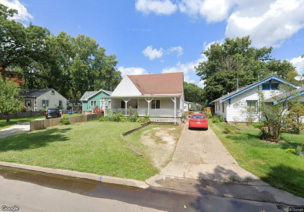
2619 Payne Rd Des Moines, IA 50310
Doudna Heights-Glen Oaks NeighborhoodEstimated Value: $193,000 - $217,631
2
Beds
1
Bath
1,188
Sq Ft
$174/Sq Ft
Est. Value
About This Home
This home is located at 2619 Payne Rd, Des Moines, IA 50310 and is currently estimated at $206,908, approximately $174 per square foot. 2619 Payne Rd is a home located in Polk County with nearby schools including Monroe Elementary School, Meredith Middle School, and Hoover High School.
Ownership History
Date
Name
Owned For
Owner Type
Purchase Details
Closed on
Apr 8, 1999
Sold by
Spuzello Edward J and Spuzello Marjorie E
Bought by
Rundle Mark and Rundle Kim
Current Estimated Value
Home Financials for this Owner
Home Financials are based on the most recent Mortgage that was taken out on this home.
Original Mortgage
$59,250
Interest Rate
6.73%
Mortgage Type
Stand Alone First
Purchase Details
Closed on
Apr 1, 1997
Sold by
Spuzello Edward J and Spuzello Marjorie E
Bought by
Rundle Mark and Rundle Kim
Purchase Details
Closed on
Mar 31, 1997
Sold by
Jansen Bryan and Jansen Susan Diane
Bought by
Spuzello Edward J and Spuzello Marjorie E
Create a Home Valuation Report for This Property
The Home Valuation Report is an in-depth analysis detailing your home's value as well as a comparison with similar homes in the area
Home Values in the Area
Average Home Value in this Area
Purchase History
| Date | Buyer | Sale Price | Title Company |
|---|---|---|---|
| Rundle Mark | $52,000 | -- | |
| Rundle Mark | $52,500 | -- | |
| Spuzello Edward J | $52,000 | -- |
Source: Public Records
Mortgage History
| Date | Status | Borrower | Loan Amount |
|---|---|---|---|
| Closed | Rundle Mark | $59,250 |
Source: Public Records
Tax History Compared to Growth
Tax History
| Year | Tax Paid | Tax Assessment Tax Assessment Total Assessment is a certain percentage of the fair market value that is determined by local assessors to be the total taxable value of land and additions on the property. | Land | Improvement |
|---|---|---|---|---|
| 2025 | $3,658 | $212,300 | $37,200 | $175,100 |
| 2024 | $3,658 | $196,400 | $33,800 | $162,600 |
| 2023 | $3,448 | $196,400 | $33,800 | $162,600 |
| 2022 | $3,420 | $155,200 | $28,100 | $127,100 |
| 2021 | $3,186 | $155,200 | $28,100 | $127,100 |
| 2020 | $3,306 | $136,300 | $24,500 | $111,800 |
| 2019 | $3,100 | $136,300 | $24,500 | $111,800 |
| 2018 | $3,064 | $123,900 | $21,400 | $102,500 |
| 2017 | $2,970 | $123,900 | $21,400 | $102,500 |
| 2016 | $2,888 | $118,300 | $20,100 | $98,200 |
| 2015 | $2,888 | $118,300 | $20,100 | $98,200 |
| 2014 | $3,036 | $123,000 | $20,400 | $102,600 |
Source: Public Records
Map
Nearby Homes
- 2701 27th St
- 2523 Prospect Rd
- 2620 Arnold Rd
- 2730 Sheridan Ave
- 2516 Boston Ave
- 2413 Adams Ave
- 2515 24th St
- 2315 Holcomb Ave
- 2804 Boston Ave
- 2615 30th St
- 2823 Holcomb Ave
- 2742 Hickman Rd
- 3112 Sheridan Ave
- 3016 30th St
- 3109 Holcomb Ave
- 3120 30th St
- 2513 33rd St
- 2104 23rd St
- 2715 Allison Ave
- 2904 Shadyoak Dr