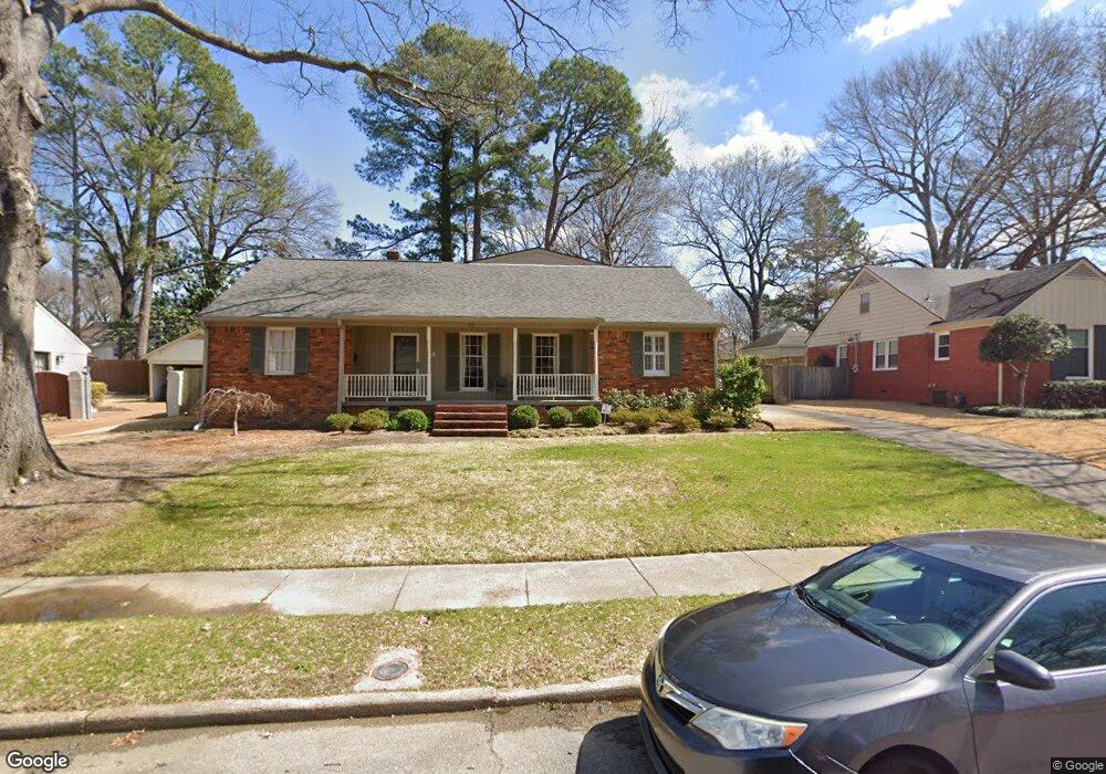
262 Lorece Ln Memphis, TN 38117
East Memphis NeighborhoodEstimated Value: $371,000 - $401,000
3
Beds
2
Baths
2,656
Sq Ft
$145/Sq Ft
Est. Value
About This Home
This home is located at 262 Lorece Ln, Memphis, TN 38117 and is currently estimated at $385,663, approximately $145 per square foot. 262 Lorece Ln is a home located in Shelby County with nearby schools including White Station Elementary School, White Station Middle, and White Station High.
Ownership History
Date
Name
Owned For
Owner Type
Purchase Details
Closed on
Dec 29, 2003
Sold by
Drew Gregg H
Bought by
Drew Carlene J
Current Estimated Value
Purchase Details
Closed on
Feb 28, 2003
Sold by
Clark Shirlee M
Bought by
Drew Carlene J
Home Financials for this Owner
Home Financials are based on the most recent Mortgage that was taken out on this home.
Original Mortgage
$126,000
Outstanding Balance
$53,243
Interest Rate
5.89%
Estimated Equity
$332,420
Purchase Details
Closed on
Dec 11, 1996
Sold by
Black Cathleen J and Black James L
Bought by
Clark Shirlee M
Home Financials for this Owner
Home Financials are based on the most recent Mortgage that was taken out on this home.
Original Mortgage
$136,500
Interest Rate
7.77%
Purchase Details
Closed on
Jun 10, 1996
Sold by
Black Cathleen J West
Bought by
Black James L and Black Cathleen J
Create a Home Valuation Report for This Property
The Home Valuation Report is an in-depth analysis detailing your home's value as well as a comparison with similar homes in the area
Home Values in the Area
Average Home Value in this Area
Purchase History
| Date | Buyer | Sale Price | Title Company |
|---|---|---|---|
| Drew Carlene J | -- | -- | |
| Drew Carlene J | $210,000 | -- | |
| Clark Shirlee M | $176,500 | -- | |
| Clark Shirlee M | $176,500 | -- | |
| Black James L | -- | -- | |
| Black James L | -- | -- |
Source: Public Records
Mortgage History
| Date | Status | Borrower | Loan Amount |
|---|---|---|---|
| Open | Drew Carlene J | $126,000 | |
| Previous Owner | Clark Shirlee M | $136,500 |
Source: Public Records
Tax History
| Year | Tax Paid | Tax Assessment Tax Assessment Total Assessment is a certain percentage of the fair market value that is determined by local assessors to be the total taxable value of land and additions on the property. | Land | Improvement |
|---|---|---|---|---|
| 2025 | $2,557 | $94,650 | $27,175 | $67,475 |
| 2024 | $2,557 | $75,425 | $27,175 | $48,250 |
| 2023 | $4,595 | $75,425 | $27,175 | $48,250 |
| 2022 | $4,595 | $75,425 | $27,175 | $48,250 |
| 2021 | $4,648 | $75,425 | $27,175 | $48,250 |
| 2020 | $4,527 | $62,475 | $27,175 | $35,300 |
| 2019 | $4,527 | $62,475 | $27,175 | $35,300 |
| 2018 | $4,527 | $62,475 | $27,175 | $35,300 |
| 2017 | $2,568 | $62,475 | $27,175 | $35,300 |
| 2016 | $2,421 | $55,400 | $0 | $0 |
| 2014 | $2,421 | $55,400 | $0 | $0 |
Source: Public Records
Map
Nearby Homes
- 4866 Barfield Rd
- 354 Avon Rd
- 352 Avon Rd
- 4798 Normandy Ln
- 371 N Mendenhall Rd
- 4935 Robindale Ln
- 320 W Peg Ln
- 4640 Chickasaw Rd
- 4561 Minden Rd
- 4931 Princeton Grove
- 455 Oma Cove
- 4565 Normandy Rd
- 4841 Fleetgrove Ave
- 4679 Walnut Grove Rd
- 5017 Henry Heights Dr
- 5045 Henry Heights Dr
- 507 Henry Heights Dr
- 5037 Henry Heights Dr
- 4525 Sequoia Rd
- 4572 Princeton Rd
Your Personal Tour Guide
Ask me questions while you tour the home.