
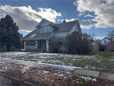


262 N 13th Ave Forsyth, MT 59327
Estimated payment $1,670/month
Highlights
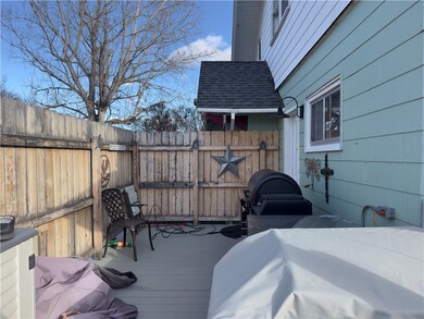
- Deck
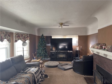
- 1 Fireplace
- Front Porch
- Forsyth Elementary School Rated A
- 2 Car Detached Garage
- Interior Lot
About This Home
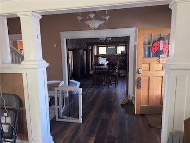
Discover this charming single-family home built in 1912, featuring beautiful built-ins, high ceilings, and a cozy wood-burning fireplace. The upper level boasts three spacious bedrooms and a full bathroom, while the main level offers an additional bathroom with a shower. This home has modern amenities with a new furnace, hot water heater, central air conditioning, and appliances- all installed within the last six years. Enjoy the comfort and efficiency in a move-in ready space! Enjoy the deck off the kitchen, along with a metal car garage and a 20 X 30 man cave in the garage area which can be used as another garage stall. It also has underground sprinkling for easy lawn maintenance. Don't miss this opportunity to own a piece of history in Forsyth! Schedule your showing today!
Listing Agent
Keller Williams Yellowstone Properties Brokerage Phone: 406-740-0317 Listed on: 12/12/2025

Home Details
Home Type
- Single Family
Est. Annual Taxes
- $1,749
Year Built
- Built in 1912
Lot Details
- 10,498 Sq Ft Lot
- Fenced
- Interior Lot
- Level Lot
- Sprinkler System
- Zoning described as Residential Subdivision
Parking
- 2 Car Detached Garage
- Alley Access
- Off-Street Parking
Home Design
- Shingle Roof
- Asphalt Roof
- Wood Siding
- Masonite
Interior Spaces
- 3,042 Sq Ft Home
- 2-Story Property
- 1 Fireplace
- Basement Fills Entire Space Under The House
Kitchen
- Oven
- Induction Cooktop
- Microwave
- Dishwasher
Bedrooms and Bathrooms
- 3 Bedrooms
- 2 Full Bathrooms
Outdoor Features
- Deck
- Patio
- Front Porch
Utilities
- Cooling Available
- Forced Air Heating System
- Heating System Uses Natural Gas
Community Details
Listing and Financial Details
- Assessor Parcel Number 0466
Map
Home Values in the Area
Average Home Value in this Area
Tax History
| Year | Tax Paid | Tax Assessment Tax Assessment Total Assessment is a certain percentage of the fair market value that is determined by local assessors to be the total taxable value of land and additions on the property. | Land | Improvement |
|---|---|---|---|---|
| 2025 | $1,750 | $205,800 | $0 | $0 |
| 2024 | $2,038 | $159,900 | $0 | $0 |
| 2023 | $1,904 | $159,900 | $0 | $0 |
| 2022 | $1,753 | $141,300 | $0 | $0 |
| 2021 | $1,679 | $141,300 | $0 | $0 |
| 2020 | $1,589 | $138,500 | $0 | $0 |
| 2019 | $1,546 | $138,500 | $0 | $0 |
| 2018 | $1,479 | $129,800 | $0 | $0 |
| 2017 | $1,438 | $129,800 | $0 | $0 |
| 2016 | $1,460 | $135,900 | $0 | $0 |
| 2015 | $1,237 | $135,900 | $0 | $0 |
| 2014 | $882 | $55,226 | $0 | $0 |
Property History
| Date | Event | Price | List to Sale | Price per Sq Ft |
|---|---|---|---|---|
| 12/12/2025 12/12/25 | For Sale | $289,900 | -- | $95 / Sq Ft |
Purchase History
| Date | Type | Sale Price | Title Company |
|---|---|---|---|
| Grant Deed | $174,250 | Other | |
| Warranty Deed | -- | None Available | |
| Warranty Deed | -- | -- |
Mortgage History
| Date | Status | Loan Amount | Loan Type |
|---|---|---|---|
| Open | $139,400 | Future Advance Clause Open End Mortgage | |
| Closed | $139,400 | New Conventional |
Source: Billings Multiple Listing Service
MLS Number: 356821
APN: 29-1540-14-4-17-09-0000
Disclaimer: Certain information contained herein is derived from information provided by parties other than Homes.com. All information provided is deemed reliable, but is not guaranteed to be accurate and should be independently verified.
![]() IDX information is provided exclusively for personal, non-commercial use, and may not be used for any purpose other than to identify prospective properties consumers may be interested in purchasing. Information is deemed reliable but not guaranteed.
IDX information is provided exclusively for personal, non-commercial use, and may not be used for any purpose other than to identify prospective properties consumers may be interested in purchasing. Information is deemed reliable but not guaranteed.