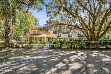
262 Wimbee Landing Rd Seabrook, SC 29940
Dale NeighborhoodEstimated payment $6,858/month
Highlights
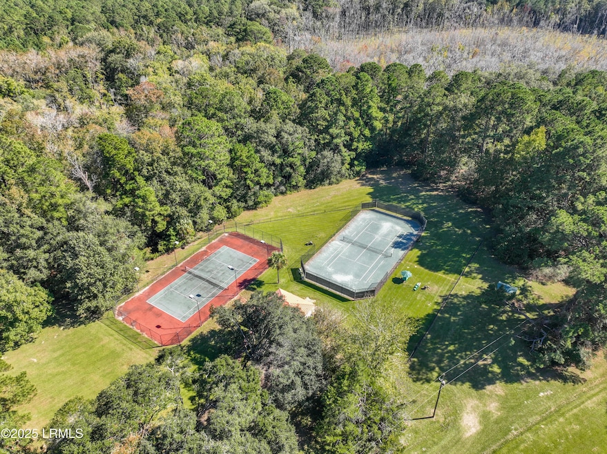
- Tennis Courts
- 20 Acre Lot
- Deck
- Gated Parking
- Fireplace in Primary Bedroom
- Recreation Room
About This Home
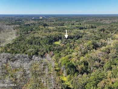
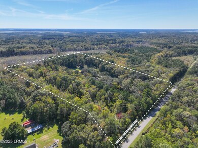
Nestled on a serene estate with a gated private entrance and a grand circular driveway lined by gorgeous mature trees, this exquisite property offers unparalleled luxury and recreation. The main house boasts 3 bedrooms downstairs—including a primary suite with bonus room, 2 fireplaces, a movie theater room, screened porch with 3 bedrooms and 2 full bathrooms upstairs, complemented by charming balconies. Step outside to two premier tennis courts: one clay court and one hard court convertible to pickleball. A separate detached studio provides versatile space, while the inviting guest house features a kitchenette, full bathroom, and expansive porch overlooking the courts. Adjacent 35 acres also available for sale—your dream compound awaits!
Home Details
Home Type
- Single Family
Est. Annual Taxes
- $3,075
Year Built
- Built in 1986
Lot Details
- 20 Acre Lot
- Partially Fenced Property
Home Design
- 2-Story Property
- Brick or Stone Mason
- Slab Foundation
- Composition Roof
- HardiePlank Siding
Interior Spaces
- 3,906 Sq Ft Home
- Ceiling Fan
- Wood Burning Fireplace
- Gas Fireplace
- Great Room
- Family Room
- Living Room with Fireplace
- 2 Fireplaces
- Formal Dining Room
- Den
- Recreation Room
- Workshop
- Screened Porch
- Security Gate
Kitchen
- Electric Oven or Range
- Dishwasher
Flooring
- Wood
- Partially Carpeted
- Tile
Bedrooms and Bathrooms
- 6 Bedrooms
- Primary Bedroom on Main
- Fireplace in Primary Bedroom
Laundry
- Dryer
- Washer
Parking
- Carport
- Gated Parking
Outdoor Features
- Tennis Courts
- Deck
- Patio
- Outdoor Storage
- Outbuilding
Additional Homes
- Accessory Dwelling Unit (ADU)
- ADU includes 1 Bedroom
Utilities
- Central Air
- Heating System Powered By Owned Propane
- Private Water Source
- Well
- Electric Water Heater
- Septic Tank
Listing and Financial Details
- Assessor Parcel Number R700-029-000-0005-0000
Community Details
Overview
- No Home Owners Association
Recreation
- Tennis Courts
Map
Home Values in the Area
Average Home Value in this Area
Tax History
| Year | Tax Paid | Tax Assessment Tax Assessment Total Assessment is a certain percentage of the fair market value that is determined by local assessors to be the total taxable value of land and additions on the property. | Land | Improvement |
|---|---|---|---|---|
| 2024 | $2,980 | $44,124 | $13,960 | $30,164 |
| 2023 | $3,075 | $44,124 | $13,960 | $30,164 |
| 2022 | $2,808 | $32,636 | $14,460 | $18,176 |
| 2021 | $2,767 | $32,636 | $14,460 | $18,176 |
| 2020 | $2,774 | $32,636 | $14,460 | $18,176 |
| 2019 | $2,713 | $32,636 | $14,460 | $18,176 |
| 2018 | $2,624 | $19,920 | $0 | $0 |
| 2017 | $2,315 | $17,390 | $0 | $0 |
| 2016 | $2,186 | $25,970 | $0 | $0 |
| 2014 | $1,566 | $25,970 | $0 | $0 |
Property History
| Date | Event | Price | List to Sale | Price per Sq Ft |
|---|---|---|---|---|
| 10/27/2025 10/27/25 | For Sale | $1,250,000 | -- | $320 / Sq Ft |
Purchase History
| Date | Type | Sale Price | Title Company |
|---|---|---|---|
| Interfamily Deed Transfer | -- | -- | |
| Interfamily Deed Transfer | -- | -- | |
| Interfamily Deed Transfer | -- | -- |
Source: Lowcountry Regional MLS
MLS Number: 193160
APN: R700-029-000-0005-0000
Disclaimer: Certain information contained herein is derived from information provided by parties other than Homes.com. All information provided is deemed reliable, but is not guaranteed to be accurate and should be independently verified.
![]() IDX information is provided exclusively for personal, non-commercial use, and may not be used for any purpose other than to identify prospective properties consumers may be interested in purchasing. Information is deemed reliable but not guaranteed.
IDX information is provided exclusively for personal, non-commercial use, and may not be used for any purpose other than to identify prospective properties consumers may be interested in purchasing. Information is deemed reliable but not guaranteed.
- 250 Wimbee Landing Rd
- 39 Middlefield Cir
- 972 Kinloch Rd
- 29 State Road S-7-769
- 181 Spann Cir
- 177 Spann Cir
- 10 Bosquet Marais
- 26 Swamprose Ln
- 1887 Trask Pkwy
- 10 N Huspah Ct
- 18 N Breeze Island
- 18 N Breeze Island
- 127 Teal Bluff Blvd
- 117 Teal Bluff Blvd
- 246 Stuart Point Rd
- 108 Stuart Point Rd
- 20 McCalley Creek Ln
- 40 Creekmoor Ln
- 16 McCalley Creek Ln
- 18 McCalley Creek Ln
- 128 Teal Bluff Blvd
- 15 Little Ln
- 44 W River Dr
- 1 Tiller Island Dr
- 29 Downing Dr
- 44 Westminister Place
- 2103 Wilson Dr
- 919 Lafayette St
- 1904 Park Ave
- 1508 Sycamore St
- 2906 Polk St
- 22 Colony Gardens Rd
- 314 Laurel Bay Rd
- 10 Whites Dr
- 1507 Washington St
- 714 Adventure St
- 503 Waight St
- 706 Charles St
- 125 New Hanover St
- 2000 Salem Rd
