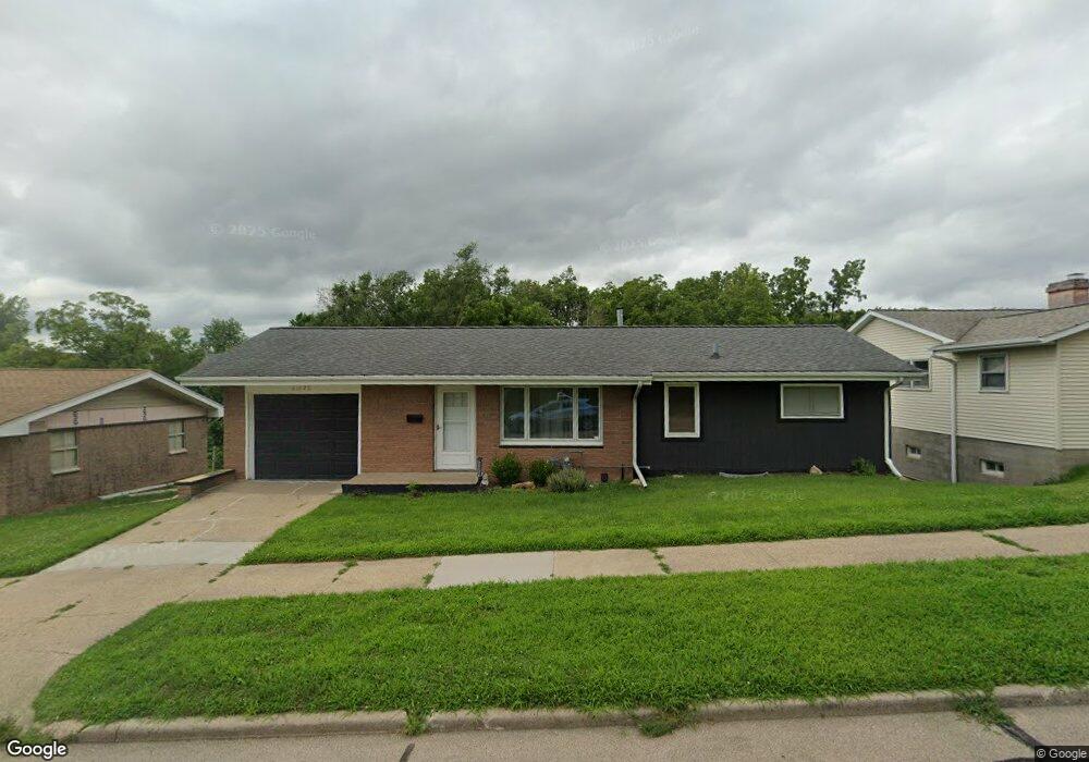
2620 Pershing Blvd Clinton, IA 52732
Estimated Value: $121,000 - $144,000
3
Beds
2
Baths
912
Sq Ft
$146/Sq Ft
Est. Value
About This Home
This home is located at 2620 Pershing Blvd, Clinton, IA 52732 and is currently estimated at $132,861, approximately $145 per square foot. 2620 Pershing Blvd is a home located in Clinton County with nearby schools including Eagle Heights Elementary School, Clinton Middle School, and Clinton High School.
Ownership History
Date
Name
Owned For
Owner Type
Purchase Details
Closed on
Mar 7, 2023
Sold by
Lashelle Anthony Michael and Lashelle Liana M
Bought by
Jewell Judy
Current Estimated Value
Home Financials for this Owner
Home Financials are based on the most recent Mortgage that was taken out on this home.
Original Mortgage
$119,995
Outstanding Balance
$110,526
Interest Rate
6.13%
Mortgage Type
New Conventional
Estimated Equity
$22,335
Purchase Details
Closed on
Dec 21, 2021
Sold by
Lakeview Loan Servicing Llc
Bought by
Lashelle Anthony Michael
Purchase Details
Closed on
Oct 18, 2017
Sold by
Mckown John Paul and Herrington Laura D
Bought by
Herrington Laura
Purchase Details
Closed on
Mar 24, 2006
Sold by
Mckown John P and Mckown Laura D
Bought by
Mckown John P and Mckown Laura D
Create a Home Valuation Report for This Property
The Home Valuation Report is an in-depth analysis detailing your home's value as well as a comparison with similar homes in the area
Purchase History
| Date | Buyer | Sale Price | Title Company |
|---|---|---|---|
| Jewell Judy | $140,000 | -- | |
| Lashelle Anthony Michael | $49,333 | Rosenberg Jay A | |
| Herrington Laura | -- | None Available | |
| Mckown John P | -- | None Available |
Source: Public Records
Mortgage History
| Date | Status | Borrower | Loan Amount |
|---|---|---|---|
| Open | Jewell Judy | $119,995 |
Source: Public Records
Tax History
| Year | Tax Paid | Tax Assessment Tax Assessment Total Assessment is a certain percentage of the fair market value that is determined by local assessors to be the total taxable value of land and additions on the property. | Land | Improvement |
|---|---|---|---|---|
| 2025 | $1,448 | $119,300 | $19,460 | $99,840 |
| 2024 | $1,448 | $110,210 | $19,460 | $90,750 |
| 2023 | $2,140 | $110,210 | $19,460 | $90,750 |
| 2022 | $2,144 | $97,851 | $11,752 | $86,099 |
| 2021 | $2,060 | $97,851 | $11,752 | $86,099 |
| 2019 | $2,128 | $97,851 | $0 | $0 |
| 2018 | $2,068 | $97,851 | $0 | $0 |
| 2017 | $2,068 | $97,851 | $0 | $0 |
| 2016 | $2,060 | $97,851 | $0 | $0 |
| 2015 | $2,060 | $97,851 | $0 | $0 |
| 2014 | $2,068 | $97,851 | $0 | $0 |
| 2013 | $2,034 | $0 | $0 | $0 |
Source: Public Records
Map
Nearby Homes
- 2711 N 2nd St
- 2515 N 3rd St
- 2918 Pershing Blvd
- 339 29th Ave N
- 2929 N 3rd St
- 2231 Pershing Blvd
- 2235 Pershing Blvd
- 2225 Pershing Blvd
- 3006 Roosevelt St
- 2908 N 4th St
- 3016 Cleveland St
- 2202 Pershing Blvd
- 320 30th Ave N
- 526 Meadowview Dr
- 2015 Garfield St
- 3016 Schick Ct
- 1913 Pershing Blvd
- 564 Scenic Dr
- 1926 N 5th St
- 901 - 905 N 2nd St
- 2614 Pershing Blvd
- 2628 Pershing Blvd
- 2632 Pershing Blvd
- 2623 Pershing Blvd
- 2617 Pershing Blvd
- 2613 Cleveland St
- 2613 Pershing Blvd
- 1301 27th Ave N
- 1300 27th Ave N
- 2607 Pershing Blvd
- 2607 Pershing Blvd Unit Blvd
- 219 27th Ave N
- 2605 Cleveland St
- 2701 Pershing Blvd
- 2701 Pershing Blvd Unit 1
- 2705 Cleveland St
- 2706 Pershing Blvd
- 2630 N 2nd St
- 2624 N 2nd St
- 2609 Cleveland St
Your Personal Tour Guide
Ask me questions while you tour the home.