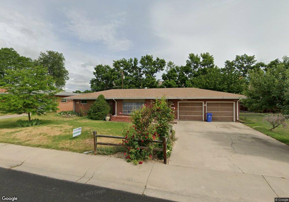
2627 Cedar Dr Loveland, CO 80538
Estimated Value: $414,000 - $443,000
3
Beds
2
Baths
1,386
Sq Ft
$310/Sq Ft
Est. Value
About This Home
This home is located at 2627 Cedar Dr, Loveland, CO 80538 and is currently estimated at $430,300, approximately $310 per square foot. 2627 Cedar Dr is a home located in Larimer County with nearby schools including Lincoln Elementary School, Lucile Erwin Middle School, and Loveland High School.
Ownership History
Date
Name
Owned For
Owner Type
Purchase Details
Closed on
Dec 24, 1997
Sold by
Flora Merlin J and Flora Mary Nell
Bought by
Flora Merlin J and Flora Mary Nell
Current Estimated Value
Purchase Details
Closed on
Oct 9, 1996
Sold by
Worland Sally
Bought by
Flora Merlin J and Flora Mary Nell
Home Financials for this Owner
Home Financials are based on the most recent Mortgage that was taken out on this home.
Original Mortgage
$112,990
Interest Rate
8.09%
Mortgage Type
Purchase Money Mortgage
Purchase Details
Closed on
Aug 1, 1993
Sold by
Downing Minnie L
Bought by
Worland Sally
Create a Home Valuation Report for This Property
The Home Valuation Report is an in-depth analysis detailing your home's value as well as a comparison with similar homes in the area
Home Values in the Area
Average Home Value in this Area
Purchase History
| Date | Buyer | Sale Price | Title Company |
|---|---|---|---|
| Flora Merlin J | -- | -- | |
| Flora Merlin J | $112,500 | -- | |
| Worland Sally | $87,000 | -- |
Source: Public Records
Mortgage History
| Date | Status | Borrower | Loan Amount |
|---|---|---|---|
| Closed | Flora Merlin J | $112,990 |
Source: Public Records
Tax History Compared to Growth
Tax History
| Year | Tax Paid | Tax Assessment Tax Assessment Total Assessment is a certain percentage of the fair market value that is determined by local assessors to be the total taxable value of land and additions on the property. | Land | Improvement |
|---|---|---|---|---|
| 2025 | $1,570 | $30,056 | $2,680 | $27,376 |
| 2024 | $1,514 | $30,056 | $2,680 | $27,376 |
| 2022 | $1,253 | $22,699 | $2,780 | $19,919 |
| 2021 | $1,288 | $23,352 | $2,860 | $20,492 |
| 2020 | $1,286 | $23,323 | $2,860 | $20,463 |
| 2019 | $1,264 | $23,323 | $2,860 | $20,463 |
| 2018 | $904 | $18,180 | $2,880 | $15,300 |
| 2017 | $778 | $18,180 | $2,880 | $15,300 |
| 2016 | $653 | $16,867 | $3,184 | $13,683 |
| 2015 | $648 | $16,860 | $3,180 | $13,680 |
| 2014 | $484 | $12,870 | $3,180 | $9,690 |
Source: Public Records
Map
Nearby Homes
- 2609 Cedar Dr
- 2311 N Garfield Ave
- 2437 Mountain View Dr
- 367 Limber Place
- 3244 Hawthorn Dr
- 706 W 29th St
- 502 Honey Locust Dr
- 3110 N Franklin Ave
- 3321 Butternut Dr
- 3210 N Colorado Ave
- 3268 Mcintosh Ct
- 1700 N Garfield Ave
- 3312 N Colorado Ave
- 957 Logan Ct
- 1612 N Cleveland Ave
- 3638 Butternut Dr Unit 7A
- 1534 Jackson Ave
- 1512 Jackson Ave
- 125 E 15th St
- 6429 Union Creek Dr