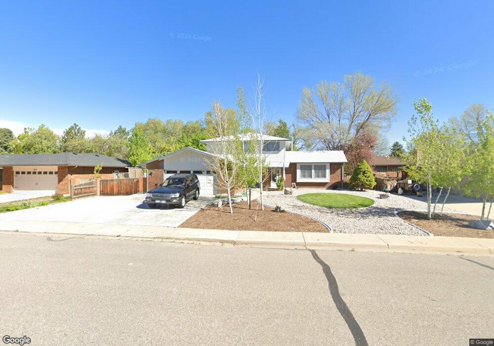
2629 Kiowa Dr Loveland, CO 80538
Estimated Value: $526,000 - $545,000
3
Beds
3
Baths
2,062
Sq Ft
$259/Sq Ft
Est. Value
About This Home
This home is located at 2629 Kiowa Dr, Loveland, CO 80538 and is currently estimated at $534,304, approximately $259 per square foot. 2629 Kiowa Dr is a home located in Larimer County with nearby schools including Ponderosa Elementary School, Bill Reed Middle School, and Loveland High School.
Ownership History
Date
Name
Owned For
Owner Type
Purchase Details
Closed on
Aug 23, 1996
Sold by
Judson Enterprises Inc
Bought by
Muzydla Thomas W and Muzydla Sharon K
Current Estimated Value
Home Financials for this Owner
Home Financials are based on the most recent Mortgage that was taken out on this home.
Original Mortgage
$11,684
Outstanding Balance
$1,224
Interest Rate
11.75%
Estimated Equity
$533,080
Purchase Details
Closed on
Apr 1, 1984
Bought by
Muzydla Thomas W
Create a Home Valuation Report for This Property
The Home Valuation Report is an in-depth analysis detailing your home's value as well as a comparison with similar homes in the area
Home Values in the Area
Average Home Value in this Area
Purchase History
| Date | Buyer | Sale Price | Title Company |
|---|---|---|---|
| Muzydla Thomas W | $24,904 | -- | |
| Muzydla Thomas W | $97,000 | -- |
Source: Public Records
Mortgage History
| Date | Status | Borrower | Loan Amount |
|---|---|---|---|
| Open | Muzydla Thomas W | $11,684 |
Source: Public Records
Tax History Compared to Growth
Tax History
| Year | Tax Paid | Tax Assessment Tax Assessment Total Assessment is a certain percentage of the fair market value that is determined by local assessors to be the total taxable value of land and additions on the property. | Land | Improvement |
|---|---|---|---|---|
| 2025 | $2,066 | $36,274 | $2,747 | $33,527 |
| 2024 | $1,993 | $36,274 | $2,747 | $33,527 |
| 2022 | $1,567 | $26,647 | $2,850 | $23,797 |
| 2021 | $1,610 | $27,414 | $2,932 | $24,482 |
| 2020 | $1,949 | $31,661 | $2,932 | $28,729 |
| 2019 | $1,916 | $31,661 | $2,932 | $28,729 |
| 2018 | $1,234 | $22,198 | $2,952 | $19,246 |
| 2017 | $1,573 | $22,198 | $2,952 | $19,246 |
| 2016 | $1,496 | $20,394 | $3,264 | $17,130 |
| 2015 | $1,483 | $20,390 | $3,260 | $17,130 |
| 2014 | $1,347 | $17,910 | $3,260 | $14,650 |
Source: Public Records
Map
Nearby Homes
- 2216 Durango Dr
- 2264 Durango Dr
- 2217 Durango Dr
- 2467 Farisita Dr
- 2628 Hayden Ct
- 1942 Lakewood Dr
- 2503 N Estrella Ave
- 2002 Falls Ct
- 1726 Kennedy Ave
- 1670 Stove Prairie Cir
- 1682 Stove Prairie Cir
- 3363 Cuchara Ct
- 2938 Glendevey Dr
- 3016 Glendevey Dr
- 1718 Dotsero Ave
- 2894 Empire Ave
- 1805 W 22nd St
- 3131 Hiawatha Dr
- 1304 Pine St
- 1506 N Empire Ave
- 2617 Kiowa Dr
- 2641 Kiowa Dr
- 2616 Iowa Place
- 2628 Iowa Place
- 2628 Kiowa Dr
- 2445 Kittredge Dr
- 2616 Kiowa Dr
- 2640 Kiowa Dr
- 2432 Indian Hills Dr
- 2444 Indian Hills Dr
- 2457 Kittredge Dr
- 2629 Iowa Place
- 2456 Indian Hills Dr
- 2604 Kiowa Dr
- 2706 Kiowa Dr
- 2617 Iowa Place
- 2527 Kittredge Dr
- 2502 Indian Hills Dr
- 2586 Kiowa Dr
- 2575 Kiowa Dr