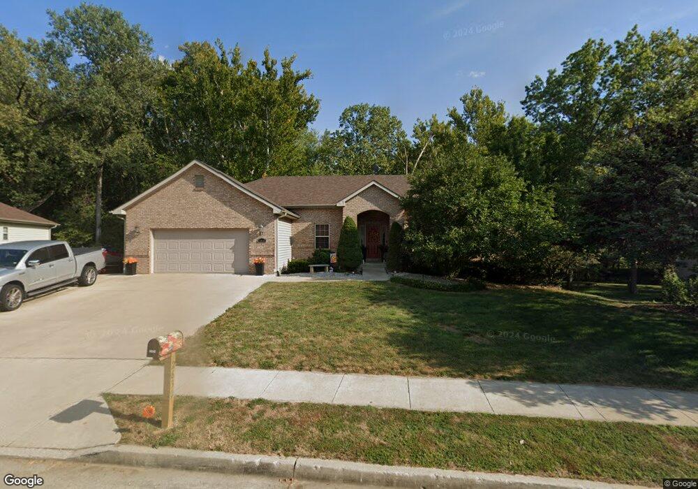
2630 Dewey Ln Columbia, MO 65202
Estimated Value: $319,000 - $358,000
3
Beds
2
Baths
1,737
Sq Ft
$197/Sq Ft
Est. Value
About This Home
This home is located at 2630 Dewey Ln, Columbia, MO 65202 and is currently estimated at $342,986, approximately $197 per square foot. 2630 Dewey Ln is a home located in Boone County with nearby schools including Eliot Battle Elementary School, John B. Lange Middle School, and Muriel W. Battle High School.
Ownership History
Date
Name
Owned For
Owner Type
Purchase Details
Closed on
Nov 14, 2006
Sold by
Miller Properties Llc
Bought by
Reimann Darrin K and Reimann Jennifer
Current Estimated Value
Home Financials for this Owner
Home Financials are based on the most recent Mortgage that was taken out on this home.
Original Mortgage
$169,500
Outstanding Balance
$100,542
Interest Rate
6.26%
Mortgage Type
New Conventional
Estimated Equity
$242,444
Create a Home Valuation Report for This Property
The Home Valuation Report is an in-depth analysis detailing your home's value as well as a comparison with similar homes in the area
Home Values in the Area
Average Home Value in this Area
Purchase History
| Date | Buyer | Sale Price | Title Company |
|---|---|---|---|
| Reimann Darrin K | -- | None Available |
Source: Public Records
Mortgage History
| Date | Status | Borrower | Loan Amount |
|---|---|---|---|
| Open | Reimann Darrin K | $169,500 |
Source: Public Records
Tax History Compared to Growth
Tax History
| Year | Tax Paid | Tax Assessment Tax Assessment Total Assessment is a certain percentage of the fair market value that is determined by local assessors to be the total taxable value of land and additions on the property. | Land | Improvement |
|---|---|---|---|---|
| 2025 | $3,276 | $49,818 | $4,085 | $45,733 |
| 2024 | $3,276 | $45,296 | $4,085 | $41,211 |
| 2023 | $3,248 | $45,296 | $4,085 | $41,211 |
| 2022 | $3,120 | $43,548 | $4,085 | $39,463 |
| 2021 | $3,125 | $43,548 | $4,085 | $39,463 |
| 2020 | $3,183 | $41,872 | $4,085 | $37,787 |
| 2019 | $3,184 | $41,872 | $4,085 | $37,787 |
| 2018 | $3,080 | $0 | $0 | $0 |
| 2017 | $3,040 | $40,261 | $4,085 | $36,176 |
| 2016 | $3,040 | $40,261 | $4,085 | $36,176 |
| 2015 | $2,808 | $40,261 | $4,085 | $36,176 |
| 2014 | $2,814 | $40,261 | $4,085 | $36,176 |
Source: Public Records
Map
Nearby Homes
- 5916 Huntington Ct
- 5917 Huntington Ct
- 000000 N Billy Jean Dr
- 5724 Black Gum Ct
- 5614 Sandrock Dr
- 6900 Armstrong Dr
- 1504 N Pin Oak Blvd
- LOT 302 Battle Ave
- 6908 E Mexico Gravel Rd
- 1537 N Lake of the Woods Rd
- 5700 E Mexico Gravel Rd
- 2009 Waterfront Dr N Unit A1
- 1999 Waterfront Dr N Unit G
- 1999 Waterfront Dr N Unit H
- LOT 3 Battle Ave
- LOT 1 Battle Ave
- 2005 Waterfront Dr N Unit E
- 1887 Waterfront Dr N Unit F
- 1312 N Lake of the Woods Rd
- 1312 N Lake of the Wood