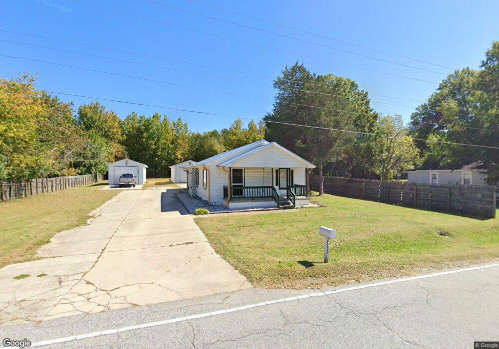
2633 Ingram Rd High Point, NC 27263
Greater High Point NeighborhoodEstimated Value: $92,000 - $220,000
3
Beds
1
Bath
784
Sq Ft
$192/Sq Ft
Est. Value
About This Home
This home is located at 2633 Ingram Rd, High Point, NC 27263 and is currently estimated at $150,641, approximately $192 per square foot. 2633 Ingram Rd is a home located in Guilford County with nearby schools including Allen Jay Elementary School, Southern Guilford Middle, and Southern Guilford High School.
Ownership History
Date
Name
Owned For
Owner Type
Purchase Details
Closed on
Aug 29, 2002
Sold by
Roseberry Dennis
Bought by
Virasone Tonny and Virasone Khankeo
Current Estimated Value
Home Financials for this Owner
Home Financials are based on the most recent Mortgage that was taken out on this home.
Original Mortgage
$62,035
Outstanding Balance
$26,386
Interest Rate
6.49%
Estimated Equity
$124,255
Create a Home Valuation Report for This Property
The Home Valuation Report is an in-depth analysis detailing your home's value as well as a comparison with similar homes in the area
Home Values in the Area
Average Home Value in this Area
Purchase History
| Date | Buyer | Sale Price | Title Company |
|---|---|---|---|
| Virasone Tonny | $65,500 | -- |
Source: Public Records
Mortgage History
| Date | Status | Borrower | Loan Amount |
|---|---|---|---|
| Open | Virasone Tonny | $62,035 |
Source: Public Records
Tax History
| Year | Tax Paid | Tax Assessment Tax Assessment Total Assessment is a certain percentage of the fair market value that is determined by local assessors to be the total taxable value of land and additions on the property. | Land | Improvement |
|---|---|---|---|---|
| 2025 | $683 | $49,600 | $20,000 | $29,600 |
| 2024 | $683 | $49,600 | $20,000 | $29,600 |
| 2023 | $683 | $49,600 | $20,000 | $29,600 |
| 2022 | $669 | $49,600 | $20,000 | $29,600 |
| 2021 | $577 | $41,900 | $17,000 | $24,900 |
| 2020 | $577 | $41,900 | $17,000 | $24,900 |
| 2019 | $577 | $41,900 | $0 | $0 |
| 2018 | $574 | $41,900 | $0 | $0 |
| 2017 | $577 | $41,900 | $0 | $0 |
| 2016 | $663 | $47,300 | $0 | $0 |
| 2015 | $667 | $47,300 | $0 | $0 |
| 2014 | $678 | $47,300 | $0 | $0 |
Source: Public Records
Map
Nearby Homes
- 611 Liberty Rd
- 000 Liberty Rd
- 1105 E Springfield Rd
- 1535 E Fairfield Rd
- 914 Nance Ave
- 717 Belmont Dr
- 126 Apollo Cir
- 706 E Fairfield Rd
- 600 E Fairfield Rd
- 715 Baker Rd
- 921 Norton St
- 1501 Cox Ct
- 1638 Kersey Valley Rd
- 510 Aldridge Rd
- 424 Aldridge Rd
- 10844 N Main St
- 10812, 10822, 10828 N Main St
- 609 Martha Place
- 607 Martha Place
- 1606 Chelsea Square
- 2635 Ingram Rd
- 2628 Ingram Rd
- 2626 Ingram Rd
- 2701 Ingram Rd
- 2616 R1 Ingram Rd
- 2630 Ingram Rd
- 2624 Ingram Rd
- 2705 Ingram Rd
- 2622 Ingram Rd
- 2702 Ingram Rd Unit A-H
- 2703 Ingram Rd
- 2707 Ingram Rd
- 2620 Ingram Rd
- 2709 Ingram Rd
- 2629 Ingram Rd
- 2618 Ingram Rd
- 2711 Ingram Rd
- 2634 Ingram Rd
- 2621 Ingram Rd
- 2713 Ingram Rd
Your Personal Tour Guide
Ask me questions while you tour the home.