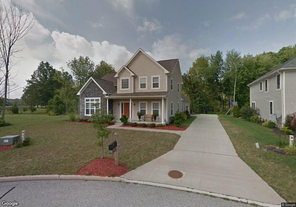
2639 Sandstone Path Hudson, OH 44236
Estimated Value: $562,000 - $697,000
3
Beds
3
Baths
3,628
Sq Ft
$169/Sq Ft
Est. Value
About This Home
This home is located at 2639 Sandstone Path, Hudson, OH 44236 and is currently estimated at $614,924, approximately $169 per square foot. 2639 Sandstone Path is a home located in Summit County with nearby schools including Ellsworth Hill Elementary School, East Woods Intermediate School, and Hudson Middle School.
Ownership History
Date
Name
Owned For
Owner Type
Purchase Details
Closed on
Jan 24, 2008
Sold by
Stonecreek Reserve Co Ltd
Bought by
Baig Mehvish and Baig Shahid N
Current Estimated Value
Purchase Details
Closed on
May 22, 2007
Sold by
Reserve Builders Llc
Bought by
Stonecreek Reserve Co Ltd
Home Financials for this Owner
Home Financials are based on the most recent Mortgage that was taken out on this home.
Original Mortgage
$218,000
Interest Rate
6.2%
Mortgage Type
Construction
Purchase Details
Closed on
Apr 20, 2007
Sold by
Stonecreek Reserve Co Ltd
Bought by
Reserve Builders Llc
Home Financials for this Owner
Home Financials are based on the most recent Mortgage that was taken out on this home.
Original Mortgage
$218,000
Interest Rate
6.2%
Mortgage Type
Construction
Create a Home Valuation Report for This Property
The Home Valuation Report is an in-depth analysis detailing your home's value as well as a comparison with similar homes in the area
Home Values in the Area
Average Home Value in this Area
Purchase History
| Date | Buyer | Sale Price | Title Company |
|---|---|---|---|
| Baig Mehvish | $84,400 | Attorney | |
| Stonecreek Reserve Co Ltd | -- | Talon Group | |
| Reserve Builders Llc | -- | The Talon Group |
Source: Public Records
Mortgage History
| Date | Status | Borrower | Loan Amount |
|---|---|---|---|
| Previous Owner | Reserve Builders Llc | $218,000 |
Source: Public Records
Tax History
| Year | Tax Paid | Tax Assessment Tax Assessment Total Assessment is a certain percentage of the fair market value that is determined by local assessors to be the total taxable value of land and additions on the property. | Land | Improvement |
|---|---|---|---|---|
| 2024 | $9,089 | $178,914 | $30,496 | $148,418 |
| 2023 | $9,089 | $178,914 | $30,496 | $148,418 |
| 2022 | $8,149 | $143,133 | $24,399 | $118,734 |
| 2021 | $8,163 | $143,133 | $24,399 | $118,734 |
| 2020 | $8,019 | $143,130 | $24,400 | $118,730 |
| 2019 | $6,682 | $110,250 | $28,150 | $82,100 |
| 2018 | $6,658 | $110,250 | $28,150 | $82,100 |
| 2017 | $6,438 | $110,250 | $28,150 | $82,100 |
| 2016 | $6,484 | $103,620 | $28,150 | $75,470 |
| 2015 | $6,438 | $103,620 | $28,150 | $75,470 |
| 2014 | $6,456 | $103,620 | $28,150 | $75,470 |
| 2013 | $6,451 | $101,120 | $28,150 | $72,970 |
Source: Public Records
Map
Nearby Homes
- 5518 Pond Ct
- 5361 Diana Lynn Dr
- 1995 Weston Dr
- 5163 Beckett Ridge
- 5150 Bayside Lake Blvd
- V/L Norton Rd
- 2353 W Hale Dr
- 5091 Ridge Meadow Dr
- 2221 Crockett Cir
- 2352 Becket Cir
- 5123 Sodalite Dr
- 5866 Ogilby Dr
- 2279 Becket Cir
- 4534 Foresthill Rd
- 1525 Spruce Hill Dr
- 4623 Cox Dr
- 4556 Fishcreek Rd
- 4424 Timberdale Dr Unit 4428
- 2344 Echo Valley Dr
- 4544 Fishcreek Rd
- 2643 Sandstone Path
- V/L Sandstone Path
- 2647 Sandstone Path
- 2635 Sandstone Path
- 2636 Sandstone Path
- 4 Sandstone Path
- 2629 Sandstone Path
- 2628 Sandstone Path
- 2651 Sandstone Path
- 5546 Stonecreek Way
- 2623 Sandstone Path
- 2617 Barlow Rd
- 5566 Stonecreek Way
- 2620 Sandstone Path
- 5538 Stonecreek Way
- 0 VL Stonecreek Way
- 2595 Barlow Rd
- 5563 Stonecreek Way
- 5530 Stonecreek Way
- 5578 Stonecreek Way
Your Personal Tour Guide
Ask me questions while you tour the home.