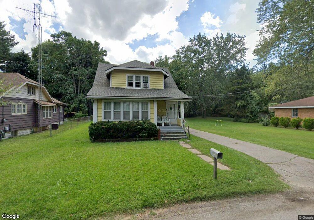
264 Eastern Ave Benton Harbor, MI 49022
Fair Plain NeighborhoodEstimated Value: $162,305 - $194,000
3
Beds
1
Bath
1,504
Sq Ft
$119/Sq Ft
Est. Value
About This Home
This home is located at 264 Eastern Ave, Benton Harbor, MI 49022 and is currently estimated at $179,576, approximately $119 per square foot. 264 Eastern Ave is a home located in Berrien County with nearby schools including Fair Plain Middle School, Benton Harbor High School, and Benton Harbor Charter School Academy.
Ownership History
Date
Name
Owned For
Owner Type
Purchase Details
Closed on
May 6, 2013
Sold by
Anderson Anthony J
Bought by
Family Circle Llc
Current Estimated Value
Purchase Details
Closed on
Mar 13, 2009
Sold by
Wells Fargo Bank Na
Bought by
The Bank Of New York Mellon and The Bank Of New York
Purchase Details
Closed on
Sep 27, 2007
Sold by
Johnson Sandra
Bought by
Wells Fargo Bank Na
Purchase Details
Closed on
Oct 26, 2006
Sold by
Johnson Sandra
Bought by
Wells Fargo Bank Na
Purchase Details
Closed on
Jan 25, 2002
Purchase Details
Closed on
Jul 30, 1999
Purchase Details
Closed on
Mar 7, 1995
Purchase Details
Closed on
Apr 13, 1994
Purchase Details
Closed on
Oct 15, 1990
Create a Home Valuation Report for This Property
The Home Valuation Report is an in-depth analysis detailing your home's value as well as a comparison with similar homes in the area
Home Values in the Area
Average Home Value in this Area
Purchase History
| Date | Buyer | Sale Price | Title Company |
|---|---|---|---|
| Family Circle Llc | -- | None Available | |
| Anderson Anthony J | -- | None Available | |
| The Bank Of New York Mellon | -- | E Title Agency Inc | |
| Wells Fargo Bank Na | $93,246 | None Available | |
| Wells Fargo Bank Na | $80,069 | None Available | |
| -- | $65,000 | -- | |
| -- | $65,000 | -- | |
| -- | $54,000 | -- | |
| -- | $35,000 | -- | |
| -- | $35,000 | -- |
Source: Public Records
Tax History
| Year | Tax Paid | Tax Assessment Tax Assessment Total Assessment is a certain percentage of the fair market value that is determined by local assessors to be the total taxable value of land and additions on the property. | Land | Improvement |
|---|---|---|---|---|
| 2025 | $1,523 | $69,000 | $0 | $0 |
| 2024 | $1,063 | $63,700 | $0 | $0 |
| 2023 | $1,013 | $62,100 | $0 | $0 |
| 2022 | $964 | $37,900 | $0 | $0 |
| 2021 | $1,340 | $35,000 | $2,100 | $32,900 |
| 2020 | $1,322 | $35,000 | $0 | $0 |
| 2019 | $1,544 | $27,500 | $1,500 | $26,000 |
| 2018 | $1,418 | $27,500 | $0 | $0 |
| 2017 | $1,399 | $27,300 | $0 | $0 |
| 2016 | $1,346 | $26,700 | $0 | $0 |
| 2015 | $1,216 | $27,600 | $0 | $0 |
| 2014 | $829 | $25,200 | $0 | $0 |
Source: Public Records
Map
Nearby Homes
- 270 Helmar Ct
- 180 Emery Ave
- 1238 Broadway
- V/L Mcalister
- 1216 Broadway
- 1342 Monroe St
- 1096 Pearl St
- 1190 Monroe St
- 1199 Monroe St
- 379 Western Ave
- 1064 Ogden Ave
- 161 Eloise Dr
- 1772 Lombard St
- 979 Lavette Ave
- 973 Lavette Ave
- 1309 Agard Ave
- 955 Colfax Ave
- 266 Parker Ave
- 177 Hastings Ave
- 167 E Delaware Ave
- 274 Eastern Ave
- 257 Eastern Ave
- 273 Eastern Ave
- 250 Eastern Ave
- 294 Eastern Ave
- 244 Eastern Ave
- 235 Eastern Ave
- 298 Eastern Ave
- 1490 Broadway
- 240 Eastern Ave
- 240 Eastern Ave
- 224 Eastern Ave
- 223 Eastern Ave
- 1502 Broadway
- 208 Eastern Ave
- 241 Hampton Rd
- 207 Eastern Ave
- 1461 Broadway
- 265 Hampton Rd
- 273 Hampton Rd
Your Personal Tour Guide
Ask me questions while you tour the home.