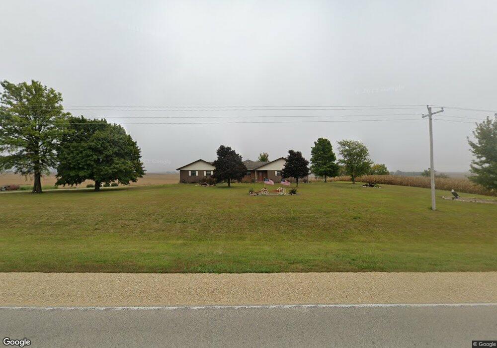
26416 Temple Ave Shell Rock, IA 50670
Estimated Value: $261,000 - $400,000
3
Beds
3
Baths
1,792
Sq Ft
$199/Sq Ft
Est. Value
About This Home
This home is located at 26416 Temple Ave, Shell Rock, IA 50670 and is currently estimated at $356,132, approximately $198 per square foot. 26416 Temple Ave is a home located in Butler County with nearby schools including Waverly-Shell Rock Senior High School.
Ownership History
Date
Name
Owned For
Owner Type
Purchase Details
Closed on
Jan 19, 2011
Sold by
Williams Margaret M and Williams Russell G
Bought by
Kerns Roger William and Kerns Tracey Lynn
Current Estimated Value
Home Financials for this Owner
Home Financials are based on the most recent Mortgage that was taken out on this home.
Original Mortgage
$204,676
Outstanding Balance
$138,593
Interest Rate
4.87%
Mortgage Type
FHA
Estimated Equity
$217,539
Purchase Details
Closed on
Feb 7, 2007
Sold by
Winkey Randall L and Winkey Carol
Bought by
Kern Margaret M
Home Financials for this Owner
Home Financials are based on the most recent Mortgage that was taken out on this home.
Original Mortgage
$145,000
Interest Rate
5.62%
Mortgage Type
Adjustable Rate Mortgage/ARM
Create a Home Valuation Report for This Property
The Home Valuation Report is an in-depth analysis detailing your home's value as well as a comparison with similar homes in the area
Purchase History
| Date | Buyer | Sale Price | Title Company |
|---|---|---|---|
| Kerns Roger William | $210,000 | None Available | |
| Kern Margaret M | $225,000 | None Available |
Source: Public Records
Mortgage History
| Date | Status | Borrower | Loan Amount |
|---|---|---|---|
| Open | Kerns Roger William | $204,676 | |
| Previous Owner | Kern Margaret M | $145,000 |
Source: Public Records
Tax History
| Year | Tax Paid | Tax Assessment Tax Assessment Total Assessment is a certain percentage of the fair market value that is determined by local assessors to be the total taxable value of land and additions on the property. | Land | Improvement |
|---|---|---|---|---|
| 2025 | $4,164 | $386,230 | $66,860 | $319,370 |
| 2024 | $4,164 | $344,920 | $46,160 | $298,760 |
| 2023 | $3,790 | $344,920 | $46,160 | $298,760 |
| 2022 | $3,648 | $291,960 | $46,160 | $245,800 |
| 2021 | $3,486 | $291,960 | $46,160 | $245,800 |
| 2020 | $3,486 | $261,430 | $46,160 | $215,270 |
| 2019 | $3,220 | $242,800 | $46,160 | $215,270 |
| 2018 | $3,188 | $242,800 | $0 | $0 |
| 2017 | $3,222 | $242,590 | $0 | $0 |
| 2016 | $3,514 | $242,590 | $0 | $0 |
| 2015 | $3,514 | $242,590 | $0 | $0 |
| 2014 | $3,620 | $242,590 | $0 | $0 |
Source: Public Records
Map
Nearby Homes
- 21164 Woodridge Ln
- 21250 Woodridge Ln
- 21146 Woodridge Ln
- 21161 Woodridge Ln
- 21273 Woodridge Ln
- 1131 Lozmar Ln
- 1130 Lozmar Ln
- 1125 Lozmar Ln
- 1124 Lozmar Ln
- 220 Elliot Ave
- 214 Elliot Ave
- 327 E Mindy Dr
- 506 N Kelly St
- 31521 Union Ave
- 31195 Willow Ave
- 31681 Spring Ave
- 8030 Washington St
- 10241 Winslow Rd
- Building site Tanner Rd
- 21269 Woodridge Ln
Your Personal Tour Guide
Ask me questions while you tour the home.