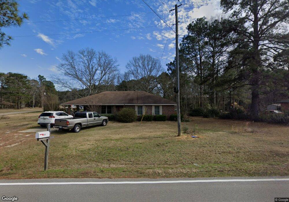
265 Burnt Bridge Rd Hattiesburg, MS 39402
Estimated Value: $128,120 - $203,000
--
Bed
--
Bath
1,196
Sq Ft
$151/Sq Ft
Est. Value
About This Home
This home is located at 265 Burnt Bridge Rd, Hattiesburg, MS 39402 and is currently estimated at $180,030, approximately $150 per square foot. 265 Burnt Bridge Rd is a home located in Lamar County with nearby schools including Oak Grove Elementary School, Bellevue Elementary School, and Oak Grove Middle School.
Ownership History
Date
Name
Owned For
Owner Type
Purchase Details
Closed on
Mar 9, 2018
Sold by
Benzell Cindy D and Mcdonald Cindy D
Bought by
Benzel Cindy D and Benzel Kenny
Current Estimated Value
Home Financials for this Owner
Home Financials are based on the most recent Mortgage that was taken out on this home.
Original Mortgage
$70,800
Outstanding Balance
$40,688
Interest Rate
4.32%
Mortgage Type
Stand Alone Refi Refinance Of Original Loan
Estimated Equity
$139,342
Create a Home Valuation Report for This Property
The Home Valuation Report is an in-depth analysis detailing your home's value as well as a comparison with similar homes in the area
Home Values in the Area
Average Home Value in this Area
Purchase History
| Date | Buyer | Sale Price | Title Company |
|---|---|---|---|
| Benzel Cindy D | -- | -- |
Source: Public Records
Mortgage History
| Date | Status | Borrower | Loan Amount |
|---|---|---|---|
| Open | Benzel Cindy D | $70,800 |
Source: Public Records
Tax History Compared to Growth
Tax History
| Year | Tax Paid | Tax Assessment Tax Assessment Total Assessment is a certain percentage of the fair market value that is determined by local assessors to be the total taxable value of land and additions on the property. | Land | Improvement |
|---|---|---|---|---|
| 2025 | $830 | $6,601 | $0 | $0 |
| 2024 | $745 | $5,923 | $0 | $0 |
| 2023 | $745 | $5,923 | $0 | $0 |
| 2022 | $429 | $5,033 | $0 | $0 |
| 2021 | $420 | $5,029 | $0 | $0 |
| 2020 | $420 | $5,029 | $0 | $0 |
| 2019 | $420 | $5,029 | $0 | $0 |
| 2018 | $412 | $4,960 | $0 | $0 |
| 2017 | $407 | $4,874 | $0 | $0 |
| 2015 | $413 | $4,919 | $0 | $0 |
| 2014 | $415 | $4,941 | $0 | $0 |
| 2013 | -- | $4,935 | $0 | $0 |
Source: Public Records
Map
Nearby Homes
- 61 Madden Rd
- 117 Hughes Rd
- 1098 Frances St
- Parcel E S Mill Creek Rd
- Parcel C S Mill Creek Rd
- 95 Burnt Bridge Rd
- 2262 Highway 589
- 60 Grand Blvd
- 000 Davis Rd
- 36 S Bridle Bend
- 44 Nicolaus Dr
- 46 Scarlet St
- 13 S Bridle Bend
- 000 Burnt Bridge Rd
- 5 E Lariat Ln
- 0 Summer Place
- 5 Summer Place
- 0 Bounds Ln
- 45 Reagan Dr
- Lot 4 Rabbit Trail
- 261 Burnt Bridge Rd
- 54 Prine Cir
- 273 Burnt Bridge Rd
- 253 Burnt Bridge Rd
- 50 Prine Cir
- 51 Prine Cir
- 12 Johnnie McMurray Rd
- 16 Johnnie McMurray Rd
- 20 Johnnie McMurray Rd
- 245 Burnt Bridge Rd
- 24 Johnnie McMurray Rd
- 42 Prine Cir
- 43 Prine Cir
- 241 Burnt Bridge Rd
- 281 Burnt Bridge Rd
- 23 Johnnie McMurray Rd
- 00 Hughes Rd
- 15 Johnnie McMurry Rd
- 296 Burnt Bridge Rd
- 34 Prine Cir