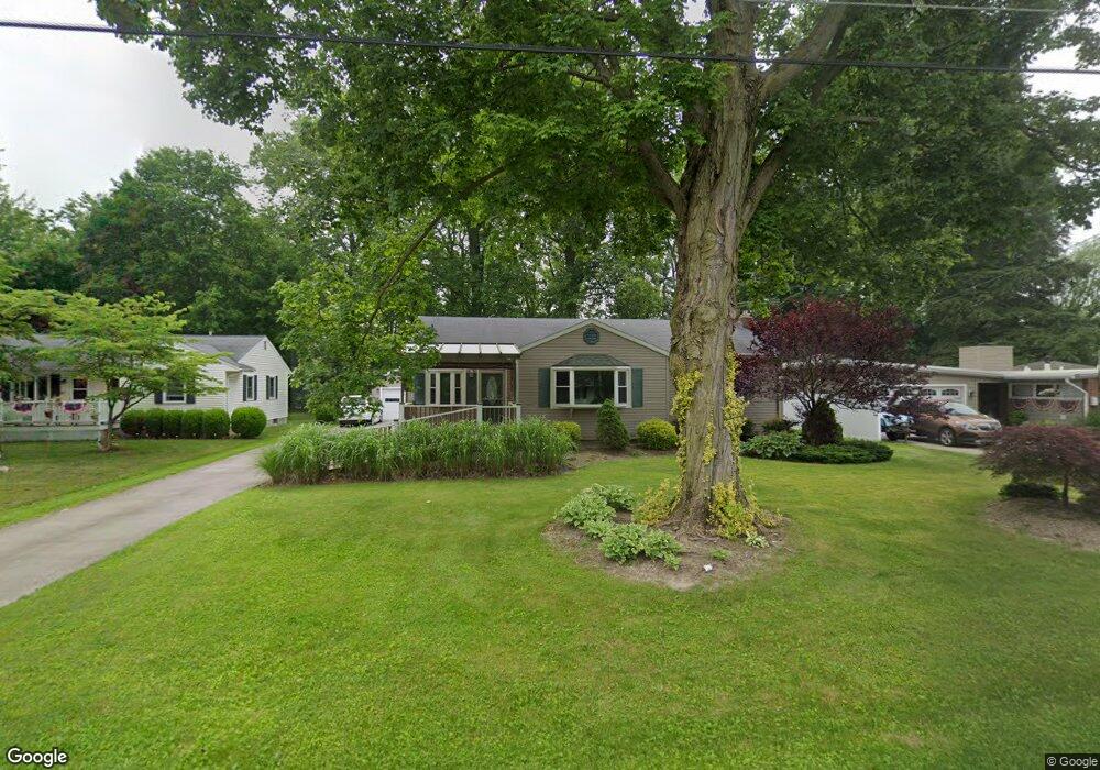
265 Crocker St Amherst, OH 44001
Estimated Value: $220,000 - $275,000
2
Beds
2
Baths
1,475
Sq Ft
$168/Sq Ft
Est. Value
About This Home
This home is located at 265 Crocker St, Amherst, OH 44001 and is currently estimated at $247,728, approximately $167 per square foot. 265 Crocker St is a home located in Lorain County with nearby schools including Powers Elementary School, Walter G. Nord Middle School, and Amherst Junior High School.
Ownership History
Date
Name
Owned For
Owner Type
Purchase Details
Closed on
Jun 13, 2003
Sold by
Wade Dorothy M Trustee
Bought by
Glass George S
Current Estimated Value
Home Financials for this Owner
Home Financials are based on the most recent Mortgage that was taken out on this home.
Original Mortgage
$76,800
Interest Rate
5.71%
Mortgage Type
Purchase Money Mortgage
Purchase Details
Closed on
May 12, 1998
Sold by
Wade Dorothy M
Bought by
Wade Dorothy M and Dorothy M Wade Family Trust
Create a Home Valuation Report for This Property
The Home Valuation Report is an in-depth analysis detailing your home's value as well as a comparison with similar homes in the area
Home Values in the Area
Average Home Value in this Area
Purchase History
| Date | Buyer | Sale Price | Title Company |
|---|---|---|---|
| Glass George S | $96,000 | Real Estate Title | |
| Wade Dorothy M | -- | -- |
Source: Public Records
Mortgage History
| Date | Status | Borrower | Loan Amount |
|---|---|---|---|
| Closed | Glass George S | $76,800 |
Source: Public Records
Tax History Compared to Growth
Tax History
| Year | Tax Paid | Tax Assessment Tax Assessment Total Assessment is a certain percentage of the fair market value that is determined by local assessors to be the total taxable value of land and additions on the property. | Land | Improvement |
|---|---|---|---|---|
| 2024 | $2,562 | $73,248 | $18,547 | $54,702 |
| 2023 | $2,277 | $56,686 | $13,881 | $42,805 |
| 2022 | $2,202 | $56,686 | $13,881 | $42,805 |
| 2021 | $2,208 | $56,686 | $13,881 | $42,805 |
| 2020 | $2,105 | $49,330 | $12,080 | $37,250 |
| 2019 | $2,063 | $49,330 | $12,080 | $37,250 |
| 2018 | $2,046 | $49,330 | $12,080 | $37,250 |
| 2017 | $2,018 | $45,820 | $10,630 | $35,190 |
| 2016 | $2,035 | $45,820 | $10,630 | $35,190 |
| 2015 | $2,023 | $45,820 | $10,630 | $35,190 |
| 2014 | $1,869 | $42,830 | $9,940 | $32,890 |
| 2013 | $1,564 | $37,180 | $9,940 | $27,240 |
Source: Public Records
Map
Nearby Homes
- 621 Van Oaks Dr
- 0 Stonebridge Dr
- 748 Tarry Ln
- 394 Long St
- 2176 Myla Way
- 2180 Myla Way
- 483 N Main St
- 814 Valley Dr
- 7055 Quarry Rd Unit 440
- 7055 Quarry Rd Unit 43
- 7055 Quarry Rd Unit 95
- 7055 Quarry Rd Unit 33
- 7055 Quarry Rd Unit 370
- 7055 Quarry Rd Unit 8
- 7055 Quarry Rd Unit 98
- 7055 Quarry Rd Unit 235
- 292 Westwoods
- 302 Westwoods
- 335 Copper Creek
- 658 Nicole Dr