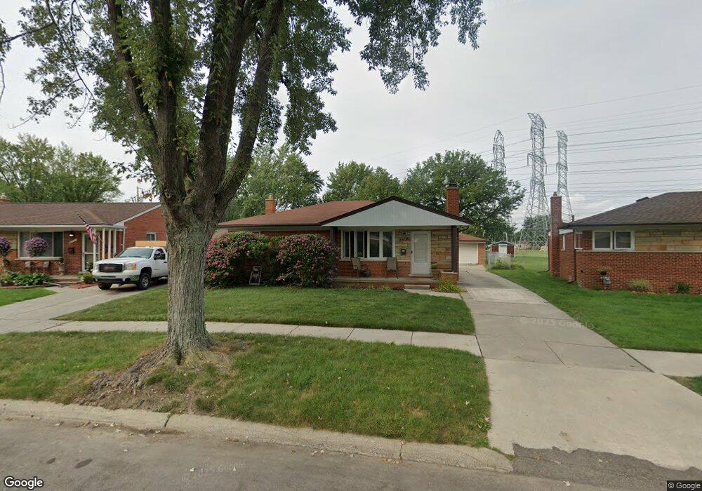
26537 Newport Ave Warren, MI 48089
Southeast Warren NeighborhoodEstimated Value: $227,240 - $247,000
3
Beds
2
Baths
1,191
Sq Ft
$198/Sq Ft
Est. Value
About This Home
This home is located at 26537 Newport Ave, Warren, MI 48089 and is currently estimated at $236,310, approximately $198 per square foot. 26537 Newport Ave is a home located in Macomb County with nearby schools including Warren Woods Tower High School and Frontier International Academy Elementary.
Ownership History
Date
Name
Owned For
Owner Type
Purchase Details
Closed on
Sep 28, 2011
Sold by
Jasmund Otto and Jasmund Karren
Bought by
Jasmund & Jasmund Llc
Current Estimated Value
Purchase Details
Closed on
Sep 13, 2011
Sold by
Fannie Mae
Bought by
Jasmund Otto
Purchase Details
Closed on
Apr 29, 2011
Sold by
Bac Home Loans Servicing Lp
Bought by
Fannie Mae
Purchase Details
Closed on
Oct 1, 2010
Sold by
Casey Ann Marie
Bought by
Bac Home Loans Servicing Lp
Purchase Details
Closed on
Jan 23, 1998
Sold by
Delang J P
Bought by
Casey A
Create a Home Valuation Report for This Property
The Home Valuation Report is an in-depth analysis detailing your home's value as well as a comparison with similar homes in the area
Home Values in the Area
Average Home Value in this Area
Purchase History
| Date | Buyer | Sale Price | Title Company |
|---|---|---|---|
| Jasmund & Jasmund Llc | -- | None Available | |
| Jasmund Otto | $45,000 | Attorneys Title Agency Llc | |
| Fannie Mae | -- | None Available | |
| Bac Home Loans Servicing Lp | $79,309 | None Available | |
| Casey A | $117,000 | -- |
Source: Public Records
Tax History Compared to Growth
Tax History
| Year | Tax Paid | Tax Assessment Tax Assessment Total Assessment is a certain percentage of the fair market value that is determined by local assessors to be the total taxable value of land and additions on the property. | Land | Improvement |
|---|---|---|---|---|
| 2025 | $3,732 | $107,360 | $0 | $0 |
| 2024 | $3,653 | $95,310 | $0 | $0 |
| 2023 | $3,458 | $86,790 | $0 | $0 |
| 2022 | $3,279 | $77,780 | $0 | $0 |
| 2021 | $3,244 | $74,430 | $0 | $0 |
| 2020 | $3,142 | $69,960 | $0 | $0 |
| 2019 | $3,035 | $65,540 | $0 | $0 |
| 2018 | $3,045 | $52,620 | $0 | $0 |
| 2017 | $2,912 | $49,660 | $8,230 | $41,430 |
| 2016 | $2,893 | $49,660 | $0 | $0 |
| 2015 | -- | $45,860 | $0 | $0 |
| 2012 | -- | $42,230 | $0 | $0 |
Source: Public Records
Map
Nearby Homes
- 26515 Newport Ave
- 13144 Stamford Ave
- 26443 Marilyn Ave
- 13203 Frazho Rd
- 13171 Burgundy Ave
- 26552 Wagner Ave
- 12291 E 11 Mile Rd
- 25653 Palomino Ave
- 11927 Stamford Ave
- 26640 Schoenherr Rd
- 11920 Carney St
- 13696 Harthill Ave
- 12922 Heritage S Unit 54
- 11820 Mckinley Dr
- 27260 Norma Dr
- 13429 Zagaiski Ave
- 27529 Roan Dr
- 0000 Frazho Rd
- 13653 Brainbridge Ave
- 25317 Wagner Ave
- 26547 Newport Ave
- 26527 Newport Ave
- 26345 Newport Ave
- 26335 Newport Ave
- 26557 Newport Ave
- 26607 Newport Ave
- 26325 Newport Ave
- 26548 Newport Ave
- 26530 Newport Ave
- 26619 Newport Ave
- 26512 Newport Ave
- 26608 Newport Ave
- 26315 Newport Ave
- 26348 Newport Ave
- 26364 Newport Ave
- 26631 Newport Ave
- 26620 Newport Ave
- 26322 Newport Ave
- 26303 Newport Ave Unit Bldg-Unit
- 26303 Newport Ave