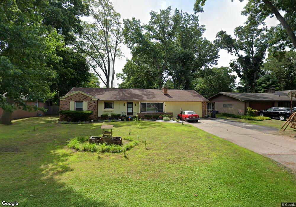
266 Cherokee Trail Benton Harbor, MI 49022
Fair Plain NeighborhoodEstimated Value: $222,000 - $252,000
3
Beds
2
Baths
1,795
Sq Ft
$133/Sq Ft
Est. Value
About This Home
This home is located at 266 Cherokee Trail, Benton Harbor, MI 49022 and is currently estimated at $239,437, approximately $133 per square foot. 266 Cherokee Trail is a home located in Berrien County with nearby schools including Fair Plain Middle School, Benton Harbor High School, and Benton Harbor Charter School Academy.
Ownership History
Date
Name
Owned For
Owner Type
Purchase Details
Closed on
Feb 14, 2008
Sold by
Rimpson Donald G and Rimpson Lisa
Bought by
Anderson Eugene and Anderson Tilla
Current Estimated Value
Home Financials for this Owner
Home Financials are based on the most recent Mortgage that was taken out on this home.
Original Mortgage
$121,591
Outstanding Balance
$75,444
Interest Rate
5.75%
Mortgage Type
FHA
Estimated Equity
$163,993
Purchase Details
Closed on
Mar 20, 2000
Purchase Details
Closed on
May 5, 1999
Purchase Details
Closed on
May 23, 1995
Purchase Details
Closed on
Dec 26, 1985
Purchase Details
Closed on
Jul 2, 1984
Purchase Details
Closed on
Apr 13, 1978
Create a Home Valuation Report for This Property
The Home Valuation Report is an in-depth analysis detailing your home's value as well as a comparison with similar homes in the area
Home Values in the Area
Average Home Value in this Area
Purchase History
| Date | Buyer | Sale Price | Title Company |
|---|---|---|---|
| Anderson Eugene | $123,500 | Sun Title | |
| -- | $110,000 | -- | |
| -- | $95,000 | -- | |
| -- | $100 | -- | |
| -- | $58,500 | -- | |
| -- | $53,000 | -- | |
| -- | $42,500 | -- |
Source: Public Records
Mortgage History
| Date | Status | Borrower | Loan Amount |
|---|---|---|---|
| Open | Anderson Eugene | $121,591 |
Source: Public Records
Tax History
| Year | Tax Paid | Tax Assessment Tax Assessment Total Assessment is a certain percentage of the fair market value that is determined by local assessors to be the total taxable value of land and additions on the property. | Land | Improvement |
|---|---|---|---|---|
| 2025 | $2,006 | $116,400 | $0 | $0 |
| 2024 | $1,199 | $94,100 | $0 | $0 |
| 2023 | $30 | $69,100 | $0 | $0 |
| 2022 | $30 | $65,000 | $0 | $0 |
| 2021 | $18 | $65,600 | $0 | $0 |
| 2020 | $18 | $0 | $0 | $0 |
| 2019 | $24 | $0 | $0 | $0 |
| 2018 | $25 | $0 | $0 | $0 |
| 2017 | $2 | $61,700 | $0 | $0 |
| 2016 | $1,498 | $62,300 | $0 | $0 |
| 2015 | $1,494 | $58,100 | $0 | $0 |
| 2014 | $973 | $56,900 | $0 | $0 |
Source: Public Records
Map
Nearby Homes
- 379 Western Ave
- 298 Bradford Rd
- 1295 Pontiac Rd
- 180 Emery Ave
- V/L Mcalister
- 1156 Mc Alister Ave
- 266 Parker Ave
- 1238 Broadway
- 1772 Lombard St
- 1216 Broadway
- 270 Helmar Ct
- 389 Parker Ave
- 377 Parker Ave
- 177 Hastings Ave
- 979 Lavette Ave
- 973 Lavette Ave
- 298 W Empire Ave
- 1096 Pearl St
- 1593 Columbus Ave
- 1250 Superior St
- 248 Cherokee Trail
- 276 Cherokee Trail
- 282 Cherokee Trail
- 251 Cherokee Trail
- 269 Cherokee Trail
- 233 Cherokee Trail
- 245 Western Ave
- 232 Cherokee Trail
- 225 Western Ave
- 277 Cherokee Trail
- 226 Cherokee Trail
- 304 Cherokee Trail
- 275 Western Ave
- 275 Western Ave
- 217 Western Ave
- 260 Seneca Rd
- 247 Western Ave
- 270 Seneca Rd
- 233 Western Ave
- 279 Western Ave
Your Personal Tour Guide
Ask me questions while you tour the home.