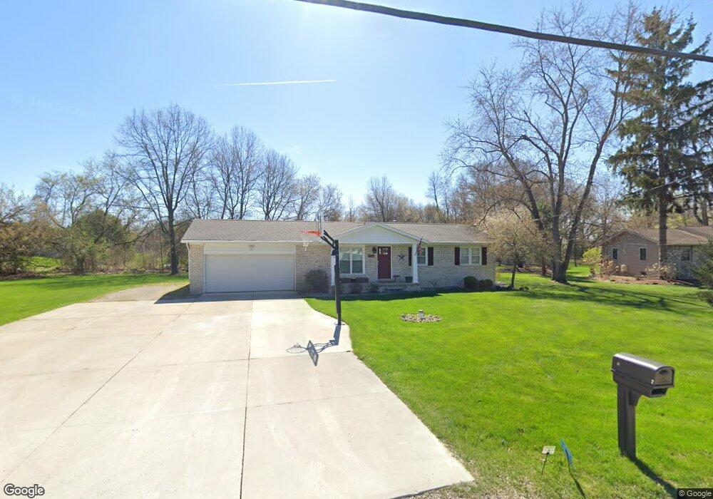
2661 Canfield Trail Brighton, MI 48114
Estimated Value: $327,000 - $466,000
3
Beds
1
Bath
1,624
Sq Ft
$246/Sq Ft
Est. Value
About This Home
This home is located at 2661 Canfield Trail, Brighton, MI 48114 and is currently estimated at $399,029, approximately $245 per square foot. 2661 Canfield Trail is a home located in Livingston County with nearby schools including Three Fires Elementary, Parker Middle School, and Howell High School.
Ownership History
Date
Name
Owned For
Owner Type
Purchase Details
Closed on
Jan 26, 2016
Sold by
Flynn Thomas M and Flynn Christine M
Bought by
Flynn Thomas M and Flynn Family Trust
Current Estimated Value
Purchase Details
Closed on
Oct 30, 2002
Sold by
Flynn Thomas M and Flynn Christine M
Bought by
Flynn Thomas M and Flynn Christine M
Purchase Details
Closed on
Jun 8, 2001
Sold by
Stabley Daniel G and Stabley K
Bought by
Flynn Thomas M and Ciochon Christine M
Purchase Details
Closed on
Jun 9, 1999
Sold by
Biron Douglas J and Biron Lee
Bought by
Stabley Daniel G and Stabley K
Home Financials for this Owner
Home Financials are based on the most recent Mortgage that was taken out on this home.
Original Mortgage
$127,000
Interest Rate
7.15%
Create a Home Valuation Report for This Property
The Home Valuation Report is an in-depth analysis detailing your home's value as well as a comparison with similar homes in the area
Home Values in the Area
Average Home Value in this Area
Purchase History
| Date | Buyer | Sale Price | Title Company |
|---|---|---|---|
| Flynn Thomas M | -- | None Available | |
| Flynn Thomas M | -- | -- | |
| Flynn Thomas M | $173,900 | Metropolitan Title Company | |
| Stabley Daniel G | $147,000 | -- |
Source: Public Records
Mortgage History
| Date | Status | Borrower | Loan Amount |
|---|---|---|---|
| Previous Owner | Stabley Daniel G | $127,000 |
Source: Public Records
Tax History Compared to Growth
Tax History
| Year | Tax Paid | Tax Assessment Tax Assessment Total Assessment is a certain percentage of the fair market value that is determined by local assessors to be the total taxable value of land and additions on the property. | Land | Improvement |
|---|---|---|---|---|
| 2025 | $2,474 | $167,100 | $0 | $0 |
| 2024 | $1,566 | $158,100 | $0 | $0 |
| 2023 | $1,496 | $146,900 | $0 | $0 |
| 2022 | $2,180 | $112,700 | $0 | $0 |
| 2021 | $2,824 | $120,400 | $0 | $0 |
| 2020 | $2,162 | $116,700 | $0 | $0 |
| 2019 | $2,788 | $112,700 | $0 | $0 |
| 2018 | $2,723 | $112,300 | $0 | $0 |
| 2017 | $2,729 | $112,300 | $0 | $0 |
| 2016 | $2,756 | $97,500 | $0 | $0 |
| 2014 | $2,891 | $85,200 | $0 | $0 |
| 2012 | $2,891 | $76,900 | $0 | $0 |
Source: Public Records
Map
Nearby Homes
- 6421 Breezeway
- 7401 Herbst Rd
- 7566 Radcliffe Unit 60
- 2830 Breckenridge Dr
- 2806 Breckenridge Dr Unit 24
- 2925 E Telluride
- 1717 S Hughes Rd
- 1673 Edwin Dr
- 1605 S Hughes Rd
- 2670 Spring Grove Dr
- 1716 S Hughes Rd
- 2757 S Hacker Rd
- 1387 Catherines Way Unit 12
- 7662 Hidden Ponds Blvd Unit 2
- 8184 Woodland Shore Dr
- Woodland Plan at Woodland Shores
- 3186 Aspen Ridge Ct
- 1840 E Genoa Cir Unit 43
- 1339 Elmhurst Dr
- 1339 Pond Bluff Way Unit 31
- 6900 Simon Dr
- 2669 Canfield Trail
- 2660 Canfield Trail
- 2664 Canfield Trail
- 2668 Canfield Trail
- 2672 Canfield Trail
- 6926 Simon Dr
- 6896 Mahinske Dr
- 2677 Canfield Trail
- 2676 Canfield Trail
- 6884 Mahinske Dr
- 2681 Canfield Trail
- 2683 Canfield Trail
- 6872 Mahinske Dr
- 2684 Canfield Trail
- 6860 Mahinske Dr
- 2740 Hubert Rd
- 2687 Canfield Trail
- 6875 Mahinske Dr
- 2688 Canfield Trail