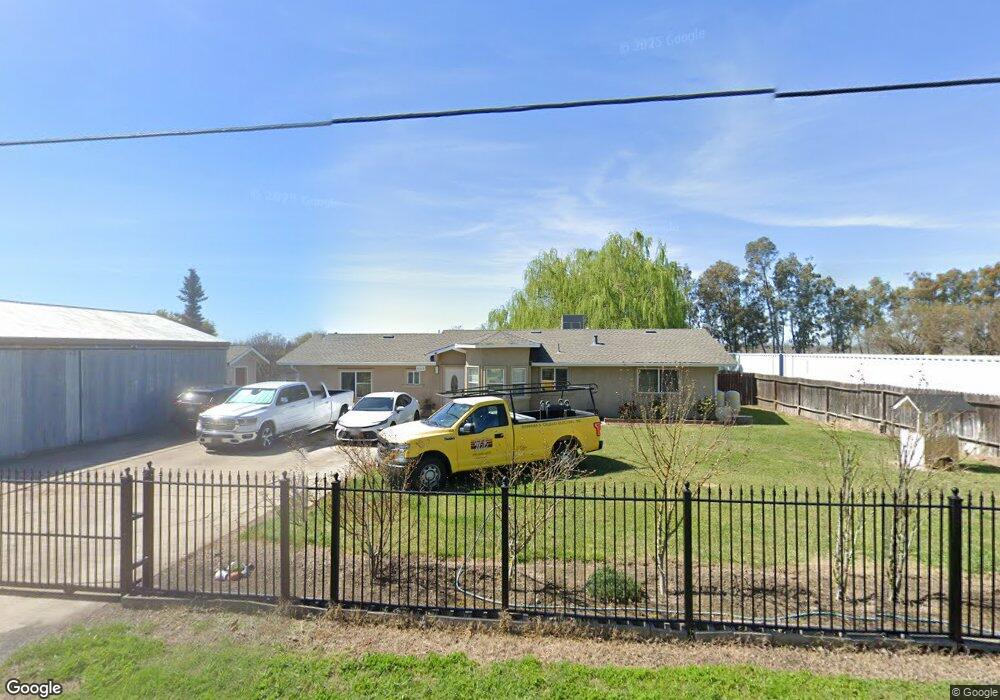
26615 N Vail Rd Thornton, CA 95686
Estimated Value: $409,000 - $3,130,000
3
Beds
1
Bath
1,568
Sq Ft
$812/Sq Ft
Est. Value
About This Home
This home is located at 26615 N Vail Rd, Thornton, CA 95686 and is currently estimated at $1,273,980, approximately $812 per square foot. 26615 N Vail Rd is a home with nearby schools including New Hope Elementary School and Galt High School.
Ownership History
Date
Name
Owned For
Owner Type
Purchase Details
Closed on
Jul 22, 2024
Sold by
Eguiluz Lucio and Eguiluz Yolanda
Bought by
Eguiluz Revocable Living Trust and Eguiluz
Current Estimated Value
Purchase Details
Closed on
Apr 18, 2003
Sold by
Latour Edward R and Latour Bonnie J
Bought by
Eguiluz Lucio P and Eguiluz Yolanda
Home Financials for this Owner
Home Financials are based on the most recent Mortgage that was taken out on this home.
Original Mortgage
$170,000
Interest Rate
5.54%
Mortgage Type
Fannie Mae Freddie Mac
Create a Home Valuation Report for This Property
The Home Valuation Report is an in-depth analysis detailing your home's value as well as a comparison with similar homes in the area
Home Values in the Area
Average Home Value in this Area
Purchase History
| Date | Buyer | Sale Price | Title Company |
|---|---|---|---|
| Eguiluz Revocable Living Trust | -- | None Listed On Document | |
| Eguiluz Lucio P | $265,000 | Fidelity Natl Title Ins Co |
Source: Public Records
Mortgage History
| Date | Status | Borrower | Loan Amount |
|---|---|---|---|
| Previous Owner | Eguiluz Lucio P | $170,000 |
Source: Public Records
Tax History Compared to Growth
Tax History
| Year | Tax Paid | Tax Assessment Tax Assessment Total Assessment is a certain percentage of the fair market value that is determined by local assessors to be the total taxable value of land and additions on the property. | Land | Improvement |
|---|---|---|---|---|
| 2025 | $2,902 | $213,265 | $97,029 | $116,236 |
| 2024 | $2,729 | $209,084 | $95,127 | $113,957 |
| 2023 | $2,686 | $204,985 | $93,262 | $111,723 |
| 2022 | $2,600 | $200,967 | $91,434 | $109,533 |
| 2021 | $2,528 | $197,028 | $89,642 | $107,386 |
| 2020 | $2,507 | $195,008 | $88,723 | $106,285 |
| 2019 | $2,458 | $191,185 | $86,984 | $104,201 |
| 2018 | $2,444 | $187,437 | $85,279 | $102,158 |
| 2017 | $2,362 | $183,762 | $83,607 | $100,155 |
| 2016 | $2,332 | $180,160 | $81,968 | $98,192 |
| 2014 | $2,071 | $159,494 | $88,608 | $70,886 |
Source: Public Records
Map
Nearby Homes
- 28725 N Vail Rd
- 10427 Barber Rd
- 10698 Barber Rd
- 27925 Thornton Rd
- 14117 Pine St
- 1332 Corodon St
- 14120 Grove St
- 14090 Winnie St
- 1269 B St
- 14055 River Rd
- 1254 A St
- 14071 River Rd
- 14105 River Rd
- 14132 Market St
- 14144 Market St
- 8181 W Kile Rd
- 14371 Race Track Rd
- 13860 State Highway 160
- 14156 California 160
- 13760 State Highway 160
- 26605 N Vail Rd
- 26755 N Vail Rd
- 26525 N Vail Rd
- 26515 N Vail Rd
- 26598 N Vail Rd
- 27001 N Vail Rd
- 27025 N Vail Rd
- 26501 N Vail Rd
- 27051 N Vail Rd
- 11999 W Walnut Grove Rd
- 29021 N Vail Rd
- 26353 N Vail Rd
- 12500 W Walnut Grove Rd
- 12525 W Walnut Grove Rd
- 11299 W Walnut Grove Rd
- 11399 W Walnut Grove Rd
- 11450 W Walnut Grove Rd
- 11299 W Walnut Grove Rd
- 0 W Lauffer Rd Unit 14051482
- 10785 W Walnut Grove Rd