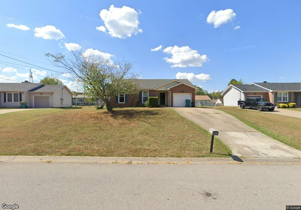
2662 Keyland Dr Clarksville, TN 37040
Estimated Value: $225,559 - $268,000
--
Bed
2
Baths
1,326
Sq Ft
$190/Sq Ft
Est. Value
About This Home
This home is located at 2662 Keyland Dr, Clarksville, TN 37040 and is currently estimated at $251,890, approximately $189 per square foot. 2662 Keyland Dr is a home located in Montgomery County with nearby schools including Glenellen Elementary School, Northeast Middle School, and Northeast High School.
Ownership History
Date
Name
Owned For
Owner Type
Purchase Details
Closed on
Oct 4, 2016
Sold by
Cayten Sarah Kay
Bought by
Busch Anthony
Current Estimated Value
Purchase Details
Closed on
Jun 30, 2009
Sold by
Starek James L
Bought by
Busch Anthony
Home Financials for this Owner
Home Financials are based on the most recent Mortgage that was taken out on this home.
Original Mortgage
$116,451
Interest Rate
5.27%
Mortgage Type
VA
Purchase Details
Closed on
Jun 27, 1997
Sold by
Crockett Gus A
Bought by
Starek James L
Create a Home Valuation Report for This Property
The Home Valuation Report is an in-depth analysis detailing your home's value as well as a comparison with similar homes in the area
Home Values in the Area
Average Home Value in this Area
Purchase History
| Date | Buyer | Sale Price | Title Company |
|---|---|---|---|
| Busch Anthony | -- | -- | |
| Busch Anthony | $114,000 | -- | |
| Starek James L | $82,500 | -- |
Source: Public Records
Mortgage History
| Date | Status | Borrower | Loan Amount |
|---|---|---|---|
| Open | Starek James L | $112,543 | |
| Previous Owner | Starek James L | $116,451 |
Source: Public Records
Tax History Compared to Growth
Tax History
| Year | Tax Paid | Tax Assessment Tax Assessment Total Assessment is a certain percentage of the fair market value that is determined by local assessors to be the total taxable value of land and additions on the property. | Land | Improvement |
|---|---|---|---|---|
| 2024 | $1,777 | $59,625 | $0 | $0 |
| 2023 | $1,777 | $33,850 | $0 | $0 |
| 2022 | $1,428 | $33,850 | $0 | $0 |
| 2021 | $1,428 | $33,850 | $0 | $0 |
| 2020 | $1,361 | $33,850 | $0 | $0 |
| 2019 | $1,361 | $33,850 | $0 | $0 |
| 2018 | $1,306 | $24,925 | $0 | $0 |
| 2017 | $376 | $30,300 | $0 | $0 |
| 2016 | $930 | $30,300 | $0 | $0 |
| 2015 | $1,277 | $30,300 | $0 | $0 |
| 2014 | $1,260 | $30,300 | $0 | $0 |
| 2013 | $1,246 | $28,450 | $0 | $0 |
Source: Public Records
Map
Nearby Homes
- 2641 Del Ray Dr
- 788 Cherrybark Ln
- 211 Sambar Dr
- 510 Needmore Rd
- 2711 Dove Ct
- 0 Dove Ct
- 2736 Ann Dr
- 0 Ann Dr
- 2738 Ann Dr
- 572 Tracy Ln
- 2819 Sparrow Dr
- 2318 Button Dr
- 2344 Pea Ridge Rd
- 2765 Ann Dr
- 2435 Pea Ridge Rd
- 2417 Pea Ridge Rd
- 2415 Pea Ridge Rd
- 2411 Pea Ridge Rd
- 2413 Pea Ridge Rd
- 2409 Pea Ridge Rd
- 2664 Keyland Dr
- 2660 Keyland Dr
- 2663 Derby Dr
- 2666 Keyland Dr
- 2665 Derby Dr
- 2658 Keyland Dr
- 2661 Derby Dr
- 2661 Keyland Dr
- 2663 Keyland Dr
- 2659 Keyland Dr
- 2667 Derby Dr
- 2668 Keyland Dr
- 2665 Keyland Dr
- 2669 Derby Dr
- 2659 Derby Dr
- 2643 Del Ray Dr
- 2647 Del Ray Dr
- 2657 Keyland Dr
- 2645 Del Ray Dr
- 2670 Keyland Dr