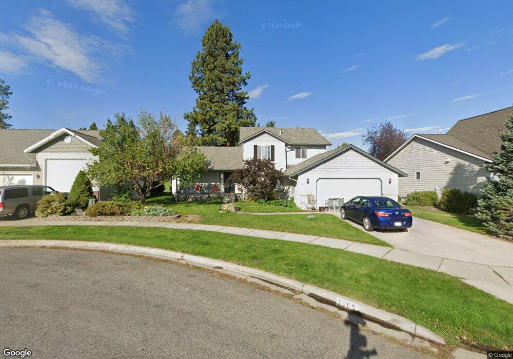
2665 N Slice Dr Post Falls, ID 83854
North Prairie NeighborhoodEstimated Value: $507,000 - $550,000
4
Beds
3
Baths
2,042
Sq Ft
$257/Sq Ft
Est. Value
About This Home
This home is located at 2665 N Slice Dr, Post Falls, ID 83854 and is currently estimated at $524,439, approximately $256 per square foot. 2665 N Slice Dr is a home located in Kootenai County with nearby schools including Mullan Trail Elementary School, Post Falls Middle School, and Post Falls High School.
Ownership History
Date
Name
Owned For
Owner Type
Purchase Details
Closed on
Jul 17, 2017
Sold by
Hall Pauline R Sherman
Bought by
Echo Ridge Llc
Current Estimated Value
Purchase Details
Closed on
Mar 20, 2014
Sold by
Hall Pauline R Sherman
Bought by
Hall Sherman and Pauline R Sherman Separate Property Revo
Purchase Details
Closed on
Aug 18, 2008
Sold by
Myers Linda Lee and Hall Susan Marie
Bought by
Hall Pauline R Sherman
Create a Home Valuation Report for This Property
The Home Valuation Report is an in-depth analysis detailing your home's value as well as a comparison with similar homes in the area
Home Values in the Area
Average Home Value in this Area
Purchase History
| Date | Buyer | Sale Price | Title Company |
|---|---|---|---|
| Echo Ridge Llc | -- | Pioneer Title | |
| Hall Sherman | -- | None Available | |
| Hall Pauline R Sherman | -- | None Available |
Source: Public Records
Tax History
| Year | Tax Paid | Tax Assessment Tax Assessment Total Assessment is a certain percentage of the fair market value that is determined by local assessors to be the total taxable value of land and additions on the property. | Land | Improvement |
|---|---|---|---|---|
| 2025 | $3,086 | $516,160 | $195,000 | $321,160 |
| 2024 | $2,865 | $457,700 | $152,000 | $305,700 |
| 2023 | $2,865 | $490,156 | $160,000 | $330,156 |
| 2022 | $3,391 | $554,340 | $187,500 | $366,840 |
| 2021 | $3,528 | $351,800 | $125,000 | $226,800 |
| 2020 | $3,456 | $305,140 | $110,000 | $195,140 |
| 2019 | $3,525 | $281,160 | $100,000 | $181,160 |
| 2018 | $3,448 | $249,680 | $85,000 | $164,680 |
| 2017 | $1,863 | $220,680 | $60,000 | $160,680 |
| 2016 | $1,782 | $203,770 | $50,000 | $153,770 |
| 2015 | $1,768 | $196,020 | $45,000 | $151,020 |
| 2013 | $771 | $166,290 | $42,000 | $124,290 |
Source: Public Records
Map
Nearby Homes
- 2815 N Slice Dr
- 2815 N Top Flight Dr
- 2815 N Sand Trap Way
- 2441 N Henry St
- 2533 N Side Saddle Ln
- 2499 Side Saddle
- 2489 N Side Saddle Ln
- 2858 N Alfalfa Loop
- 2325 N Mackenzie Dr
- 910 E Shasta Ave
- 102 W Narcissus Ct
- 2870 N Dandelion St
- 908 E Allenby Ct
- 3351 N Blaze Loop
- 1042 E Allenby Ave
- 1074 E Allenby Ave
- 3596 Blaze Loop
- 333 E Penrose Ave
- 3556 N Blaze Loop
- 3679 N Blaze Loop
- 2685 N Slice Dr
- 2655 N Slice Dr
- 2705 N Slice Dr
- 420 E Bunker Ave
- 2660 N Slice Dr
- 440 E Bunker Ave
- 2680 N Slice Dr
- 2735 N Slice Dr
- 2700 N Slice Dr
- 460 E Bunker Ave
- 2730 N Slice Dr
- 2755 N Slice Dr
- 2685 Top Flight Dr
- 2665 Top Flight Dr
- 2665 N Top Flight Ct
- 2685 N Top Flight Dr
- 2705 N Top Flight Dr
- 480 E Bunker Ave
- 2750 N Slice Dr
- 2725 Top Flight Dr
Your Personal Tour Guide
Ask me questions while you tour the home.