Estimated Value: $120,000 - $218,000
3
Beds
1
Bath
960
Sq Ft
$181/Sq Ft
Est. Value
About This Home
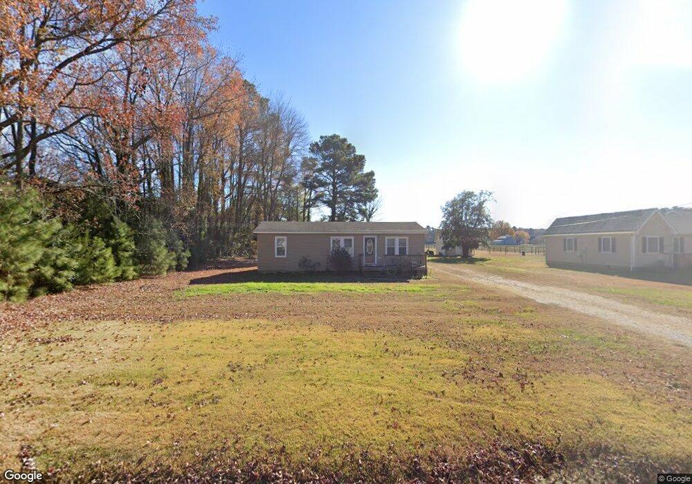
This home is located at 267 Benson Rd, Weems, VA 22576 and is currently estimated at $174,132, approximately $181 per square foot. 267 Benson Rd is a home located in Lancaster County with nearby schools including Lancaster Primary School, Lancaster Middle School, and Lancaster High School.
Ownership History
Date
Name
Owned For
Owner Type
Purchase Details
Closed on
Nov 18, 2024
Sold by
Ashburn James E and Kennedy Constance L
Bought by
Rowles Charles W
Current Estimated Value
Purchase Details
Closed on
Nov 5, 2017
Sold by
Ashburn James E and Montgomery Kelley L
Bought by
Ashburn James E and Kennedy Constance L
Home Financials for this Owner
Home Financials are based on the most recent Mortgage that was taken out on this home.
Original Mortgage
$63,717
Interest Rate
4.25%
Mortgage Type
New Conventional
Purchase Details
Closed on
Jun 5, 2017
Sold by
Coates Jason E and Coates Kendra B
Bought by
Ashburn James E and Montgomery Kelley L
Home Financials for this Owner
Home Financials are based on the most recent Mortgage that was taken out on this home.
Original Mortgage
$5,000
Interest Rate
4.05%
Mortgage Type
New Conventional
Create a Home Valuation Report for This Property
The Home Valuation Report is an in-depth analysis detailing your home's value as well as a comparison with similar homes in the area
Purchase History
| Date | Buyer | Sale Price | Title Company |
|---|---|---|---|
| Rowles Charles W | $98,000 | Old Republic National Title | |
| Ashburn James E | -- | None Available | |
| Ashburn James E | $80,000 | Attorney |
Source: Public Records
Mortgage History
| Date | Status | Borrower | Loan Amount |
|---|---|---|---|
| Previous Owner | Ashburn James E | $63,717 | |
| Previous Owner | Ashburn James E | $5,000 |
Source: Public Records
Tax History
| Year | Tax Paid | Tax Assessment Tax Assessment Total Assessment is a certain percentage of the fair market value that is determined by local assessors to be the total taxable value of land and additions on the property. | Land | Improvement |
|---|---|---|---|---|
| 2025 | $707 | $128,500 | $13,500 | $115,000 |
| 2024 | $707 | $128,500 | $13,500 | $115,000 |
| 2023 | $503 | $79,800 | $13,500 | $66,300 |
| 2022 | $503 | $79,800 | $13,500 | $66,300 |
| 2021 | $503 | $79,800 | $13,500 | $66,300 |
| 2020 | $503 | $79,800 | $13,500 | $66,300 |
| 2019 | $503 | $79,800 | $13,500 | $66,300 |
| 2018 | $482 | $81,700 | $15,000 | $66,700 |
| 2017 | $482 | $81,700 | $15,000 | $66,700 |
| 2016 | -- | $81,700 | $15,000 | $66,700 |
| 2014 | -- | $0 | $0 | $0 |
| 2013 | -- | $0 | $0 | $0 |
Source: Public Records
Map
Nearby Homes
- 12 Benson Rd
- Lot 16 Cedar Pointe Dr
- 602 Cedar Pointe Dr
- 72 James Ln
- 19 Wharton Grove Ln
- Map 3324C Sunset Dr
- 212 Gordon Dr
- 147 Sir Guy Dr
- 1678 Weems Rd
- 176 King Carter Ln
- 172 Tilden Ln
- 31 Moccasin Trail
- 102B Beechwood Dr
- 783 King Carter Dr
- 2 York Rd
- 145 Beechwood Dr
- #27-35 Berkeley Forest Rd
- Lot 27_35a Taylor's Creek Rd
- Lot 4 Levering Ln
- 197C Levering Ln
Your Personal Tour Guide
Ask me questions while you tour the home.