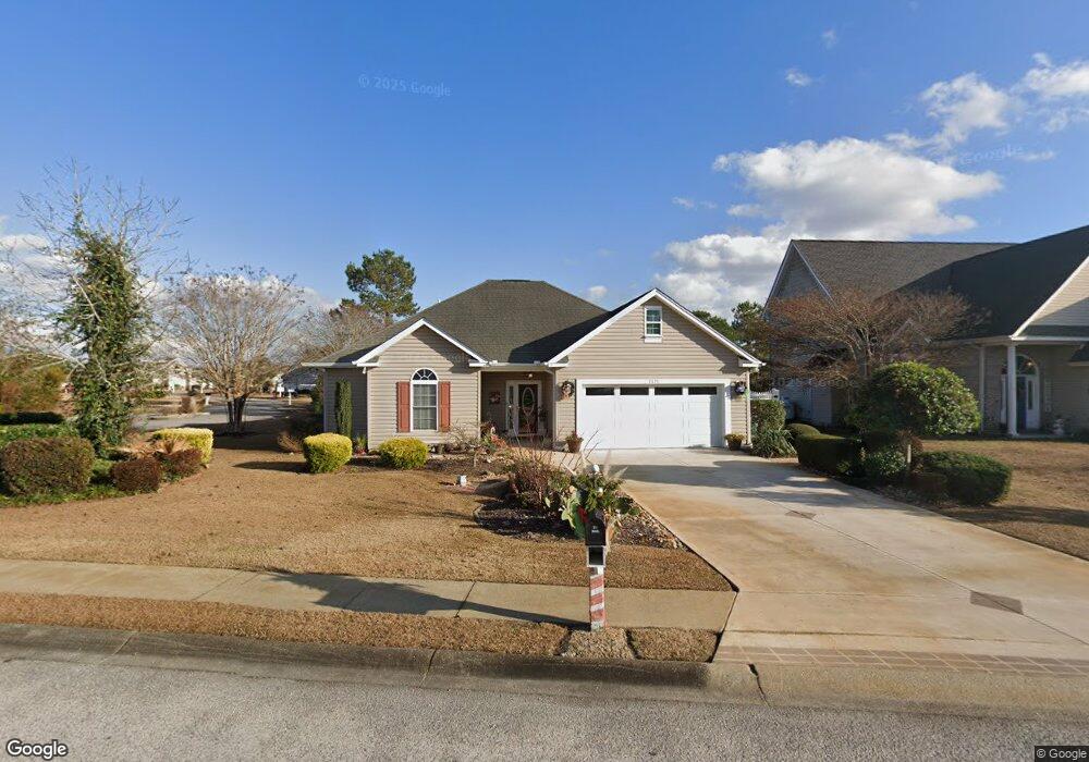
2670 Corn Pile Rd Myrtle Beach, SC 29588
Estimated Value: $297,058 - $316,000
3
Beds
3
Baths
1,396
Sq Ft
$218/Sq Ft
Est. Value
About This Home
This home is located at 2670 Corn Pile Rd, Myrtle Beach, SC 29588 and is currently estimated at $304,265, approximately $217 per square foot. 2670 Corn Pile Rd is a home located in Horry County with nearby schools including Forestbrook Elementary School, Forestbrook Middle School, and Socastee High School.
Ownership History
Date
Name
Owned For
Owner Type
Purchase Details
Closed on
Apr 7, 2009
Sold by
Michelsohn Sheila R
Bought by
Michelsohn Sheila R
Current Estimated Value
Purchase Details
Closed on
Apr 5, 2005
Sold by
Brave Properties Llc
Bought by
Michelsohn Sheila R
Home Financials for this Owner
Home Financials are based on the most recent Mortgage that was taken out on this home.
Original Mortgage
$40,000
Outstanding Balance
$19,975
Interest Rate
5.79%
Mortgage Type
Purchase Money Mortgage
Estimated Equity
$284,290
Purchase Details
Closed on
Dec 13, 2004
Sold by
Atlantis Construction Co Inc
Bought by
Brave Properties Llc
Home Financials for this Owner
Home Financials are based on the most recent Mortgage that was taken out on this home.
Original Mortgage
$124,800
Interest Rate
5.67%
Mortgage Type
Construction
Purchase Details
Closed on
Jan 27, 2004
Sold by
Hunters Ridge Of Myrtle Beach Inc
Bought by
Atlantis Construction Co Inc
Create a Home Valuation Report for This Property
The Home Valuation Report is an in-depth analysis detailing your home's value as well as a comparison with similar homes in the area
Home Values in the Area
Average Home Value in this Area
Purchase History
| Date | Buyer | Sale Price | Title Company |
|---|---|---|---|
| Michelsohn Sheila R | -- | -- | |
| Michelsohn Sheila R | $170,900 | -- | |
| Brave Properties Llc | $40,000 | -- | |
| Atlantis Construction Co Inc | $268,080 | -- |
Source: Public Records
Mortgage History
| Date | Status | Borrower | Loan Amount |
|---|---|---|---|
| Open | Michelsohn Sheila R | $40,000 | |
| Previous Owner | Brave Properties Llc | $124,800 |
Source: Public Records
Tax History
| Year | Tax Paid | Tax Assessment Tax Assessment Total Assessment is a certain percentage of the fair market value that is determined by local assessors to be the total taxable value of land and additions on the property. | Land | Improvement |
|---|---|---|---|---|
| 2025 | $746 | $0 | $0 | $0 |
| 2024 | $746 | $12,187 | $4,616 | $7,571 |
| 2023 | $746 | $6,791 | $1,435 | $5,356 |
| 2021 | $669 | $7,630 | $1,934 | $5,696 |
| 2020 | $578 | $7,630 | $1,934 | $5,696 |
| 2019 | $578 | $7,630 | $1,934 | $5,696 |
| 2018 | $515 | $5,906 | $1,242 | $4,664 |
| 2017 | $500 | $5,906 | $1,242 | $4,664 |
| 2016 | -- | $5,906 | $1,242 | $4,664 |
| 2015 | $559 | $5,906 | $1,242 | $4,664 |
| 2014 | $516 | $5,906 | $1,242 | $4,664 |
Source: Public Records
Map
Nearby Homes
- 2540 Bearstand Trail
- 2459 Hunters Trail
- 2425 Hunters Trail
- 2410 Hunters Trail
- 780 Harrison Mill St
- 2560 Wild Game Trail Unit Hunters Ridge
- 746 Harrison Mill St
- 281 La Patos Dr
- 3312 Piney Woods Way
- 2611 Ringneck Trail
- 837 Harrison Mill St
- 425 Dog Pen Ct
- 1164 Harbison Cir
- 400 Dog Pen Ct
- 1132 Harbison Cir
- 531 Harrison Mill St Unit 531
- 125 Marsh Rabbit Dr
- 317 Forestbrook Cove Cir
- 407 Big Woods Ct
- 629 Cottontail Trail Unit Hunters Ridge Crossi
- 3663 Corn Pile Rd
- 2666 Corn Pile Rd
- 2666 Corn Pile Rd Unit Hunters Ridge Landin
- 2666 Corn Pile Rd Unit Hunters Ridge
- 2769 Squealer Lake Trail Unit Hunters Ridge Legacy
- 2664 Corn Pile Rd
- 2669 Corn Pile Rd
- 2667 Corn Pile Rd
- 2768 Squealer Lake Trail
- 2662 Corn Pile Rd
- 2663 Corn Pile Rd
- 1902 Squealer Lake Covey
- 2536 Bear Stand Trail
- 2659 Corn Pile Rd
- 2538 Bear Stand Trail
- 2652 Corn Pile Rd
- 2534 Bear Stand Trail
- 2631 Corn Pile Rd
- 2760 Squealer Lake Trail
- 2657 Corn Pile Rd
Your Personal Tour Guide
Ask me questions while you tour the home.