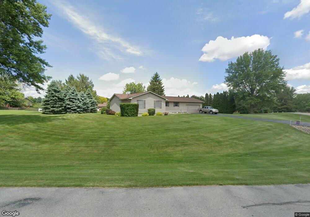
2673 Huck Finn Dr Muscatine, IA 52761
Estimated Value: $305,000 - $339,201
3
Beds
4
Baths
1,984
Sq Ft
$163/Sq Ft
Est. Value
About This Home
This home is located at 2673 Huck Finn Dr, Muscatine, IA 52761 and is currently estimated at $323,050, approximately $162 per square foot. 2673 Huck Finn Dr is a home located in Muscatine County with nearby schools including Madison Elementary School, Central Middle School, and Susan Clark Junior High School.
Ownership History
Date
Name
Owned For
Owner Type
Purchase Details
Closed on
Sep 3, 2025
Sold by
Niebaum David R and Niebaum Crystal F
Bought by
David And Crystal Niebaum Revocable Trust and Niebaum
Current Estimated Value
Purchase Details
Closed on
Jan 15, 2010
Sold by
Schliesman Thomas R and Schliesman Berdena M
Bought by
Niebaum David R
Home Financials for this Owner
Home Financials are based on the most recent Mortgage that was taken out on this home.
Original Mortgage
$176,739
Interest Rate
5.25%
Mortgage Type
FHA
Create a Home Valuation Report for This Property
The Home Valuation Report is an in-depth analysis detailing your home's value as well as a comparison with similar homes in the area
Home Values in the Area
Average Home Value in this Area
Purchase History
| Date | Buyer | Sale Price | Title Company |
|---|---|---|---|
| David And Crystal Niebaum Revocable Trust | -- | None Listed On Document | |
| Niebaum David R | $180,000 | None Available |
Source: Public Records
Mortgage History
| Date | Status | Borrower | Loan Amount |
|---|---|---|---|
| Previous Owner | Niebaum David R | $176,739 |
Source: Public Records
Tax History Compared to Growth
Tax History
| Year | Tax Paid | Tax Assessment Tax Assessment Total Assessment is a certain percentage of the fair market value that is determined by local assessors to be the total taxable value of land and additions on the property. | Land | Improvement |
|---|---|---|---|---|
| 2025 | $3,130 | $271,150 | $45,050 | $226,100 |
| 2024 | $3,130 | $269,040 | $45,050 | $223,990 |
| 2023 | $3,006 | $268,180 | $45,050 | $223,130 |
| 2022 | $2,846 | $233,320 | $42,500 | $190,820 |
| 2021 | $2,846 | $216,720 | $42,500 | $174,220 |
| 2020 | $2,692 | $196,300 | $34,350 | $161,950 |
| 2019 | $2,808 | $193,190 | $0 | $0 |
| 2018 | $2,724 | $193,190 | $0 | $0 |
| 2017 | $2,724 | $188,650 | $0 | $0 |
| 2016 | $2,788 | $188,650 | $0 | $0 |
| 2015 | $2,788 | $186,330 | $0 | $0 |
| 2014 | $2,912 | $186,330 | $0 | $0 |
Source: Public Records
Map
Nearby Homes
- 2688 Becky Thatcher Rd
- 2622 Bayfield Rd
- LOT M8 Whispering Pines
- LOT M7 Whispering Pines
- 1895 Ashford Ave
- 1899 Ashford Ave
- 1885 Highway 38
- 2623 Anna Elizabeth
- 2617 Anna Elizabeth
- 2618 Anna Elizabeth
- 2613 Anna Elizabeth
- 2612 Anna Elizabeth
- 2609 Anna Elizabeth
- 2610 Anna Elizabeth
- 2605 Anna Elizabeth
- 2604 Anna Elizabeth
- 16 Coventry Ln Unit J1
- 2582 Canterbury Rd
- 613 Lake Park Blvd
- 503 Mcarthur St
- 2671 Huck Finn Dr
- 2672 Samuel Clemens Rd
- 2674 Samuel Clemens Rd
- 2678 Huck Finn Dr
- 2680 Huck Finn Dr
- 2674 Huck Finn Dr
- 2672 Huck Finn Dr
- 2682 Huck Finn Dr
- 2676 Huck Finn Dr
- 2661 Samuel Clemens Rd
- 2665 Aunt Polly Ln
- 2663 Samuel Clemens Rd
- 2675 Samuel Clemens Rd
- 2677 Samuel Clemens Rd
- 2689 Samuel Clemens Rd
- 2678 Samuel Clemens Rd
- 2671 Samuel Clemens Rd
- 2660 Samuel Clemens Rd
- 2665 Samuel Clemens Rd
- 2667 Aunt Polly Ln