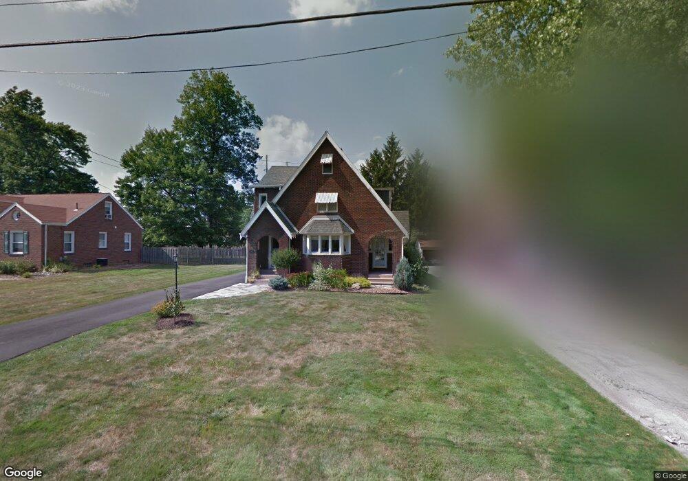
268 Brookfield Ave Youngstown, OH 44512
Estimated Value: $194,000 - $219,000
3
Beds
2
Baths
1,824
Sq Ft
$114/Sq Ft
Est. Value
About This Home
This home is located at 268 Brookfield Ave, Youngstown, OH 44512 and is currently estimated at $207,753, approximately $113 per square foot. 268 Brookfield Ave is a home located in Mahoning County with nearby schools including West Boulevard Elementary School, Boardman Center Middle School, and Boardman High School.
Ownership History
Date
Name
Owned For
Owner Type
Purchase Details
Closed on
Jul 18, 2018
Sold by
Desocio Jean M
Bought by
Desocio Joel M and Desocio Peter A
Current Estimated Value
Purchase Details
Closed on
May 21, 1999
Sold by
Ghuncha Muhammad N
Bought by
Desocio Jean M
Purchase Details
Closed on
Nov 10, 1994
Sold by
Edward C Helman Est
Bought by
Nawaz Muhammad and Nawaz Mussarrat
Purchase Details
Closed on
Sep 21, 1971
Bought by
Helman Edward C
Create a Home Valuation Report for This Property
The Home Valuation Report is an in-depth analysis detailing your home's value as well as a comparison with similar homes in the area
Home Values in the Area
Average Home Value in this Area
Purchase History
| Date | Buyer | Sale Price | Title Company |
|---|---|---|---|
| Desocio Joel M | -- | None Available | |
| Desocio Jean M | $78,000 | -- | |
| Nawaz Muhammad | $60,500 | -- | |
| Helman Edward C | -- | -- |
Source: Public Records
Mortgage History
| Date | Status | Borrower | Loan Amount |
|---|---|---|---|
| Closed | Desocio Jean M | $0 |
Source: Public Records
Tax History Compared to Growth
Tax History
| Year | Tax Paid | Tax Assessment Tax Assessment Total Assessment is a certain percentage of the fair market value that is determined by local assessors to be the total taxable value of land and additions on the property. | Land | Improvement |
|---|---|---|---|---|
| 2024 | $3,309 | $63,520 | $5,440 | $58,080 |
| 2023 | $3,266 | $63,520 | $5,440 | $58,080 |
| 2022 | $2,227 | $32,870 | $5,090 | $27,780 |
| 2021 | $2,229 | $32,870 | $5,090 | $27,780 |
| 2020 | $2,240 | $32,870 | $5,090 | $27,780 |
| 2019 | $2,177 | $28,090 | $4,350 | $23,740 |
| 2018 | $1,825 | $28,090 | $4,350 | $23,740 |
| 2017 | $1,919 | $28,090 | $4,350 | $23,740 |
| 2016 | $2,037 | $31,510 | $4,950 | $26,560 |
| 2015 | $1,996 | $31,510 | $4,950 | $26,560 |
| 2014 | $2,002 | $31,510 | $4,950 | $26,560 |
| 2013 | $1,977 | $31,510 | $4,950 | $26,560 |
Source: Public Records
Map
Nearby Homes
- 272 Ewing Rd
- 242 Oakley Ave
- 280 Wildwood Dr
- 107 Oakley Ave
- 6892 Glenwood Ave
- 6726 Glendale Ave
- 103 Wildwood Dr
- 396 Brookfield Ave
- 7005 Paxton Rd
- 418 Jaronte Dr
- 7216 Glendale Ave
- 169 Wolcott Dr
- 772 Ewing Rd
- 7340 Westview Dr
- 44 Gertrude Ave
- 7367 Oregon Trail
- 88 Arlene Ave
- 813 Brookfield Ave
- 7387 Oregon Trail
- 6938 Ron Park Place
- 264 Brookfield Ave
- 278 Brookfield Ave
- 256 Brookfield Ave
- 290 Brookfield Ave
- 248 Brookfield Ave
- 292 Brookfield Ave
- 265 Brookfield Ave
- 261 Brookfield Ave
- 267 Brookfield Ave
- 259 Brookfield Ave
- 275 Brookfield Ave
- 246 Brookfield Ave
- 294 Brookfield Ave
- 253 Brookfield Ave
- 279 Brookfield Ave
- 247 Brookfield Ave
- 244 Brookfield Ave
- 283 Brookfield Ave
- 243 Brookfield Ave
- 262 Ewing Rd