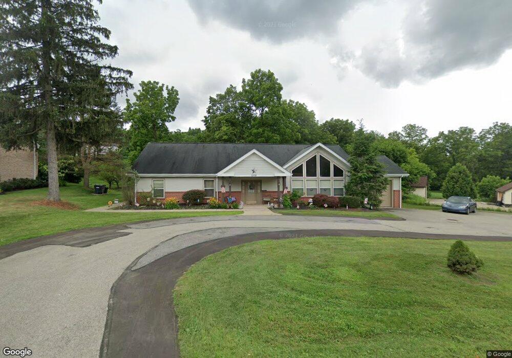
268 Hays Rd Pittsburgh, PA 15241
Estimated Value: $417,000 - $552,000
4
Beds
3
Baths
2,653
Sq Ft
$188/Sq Ft
Est. Value
About This Home
This home is located at 268 Hays Rd, Pittsburgh, PA 15241 and is currently estimated at $499,796, approximately $188 per square foot. 268 Hays Rd is a home located in Allegheny County with nearby schools including Upper St. Clair High School, St. Louise De Marillac School, and Cornerstone Christian Preparatory Academy Wilson Campus.
Ownership History
Date
Name
Owned For
Owner Type
Purchase Details
Closed on
Jul 25, 2018
Sold by
Residential Resources Inc
Bought by
Citizen Care Inc
Current Estimated Value
Purchase Details
Closed on
Feb 27, 2002
Sold by
Otoole Mary Ellen
Bought by
Residential Resources Inc
Purchase Details
Closed on
Sep 9, 1998
Sold by
Otoole Jeanne M and Otoole Rodger E
Bought by
Otoole Mary Ellen
Purchase Details
Closed on
Nov 28, 1994
Sold by
Zupkow Doris
Bought by
Otoole Rodger E and Otoole Jeanne M
Purchase Details
Closed on
Jan 1, 1900
Create a Home Valuation Report for This Property
The Home Valuation Report is an in-depth analysis detailing your home's value as well as a comparison with similar homes in the area
Home Values in the Area
Average Home Value in this Area
Purchase History
| Date | Buyer | Sale Price | Title Company |
|---|---|---|---|
| Citizen Care Inc | $256,400 | Attorney | |
| Residential Resources Inc | $82,000 | -- | |
| Otoole Mary Ellen | -- | -- | |
| Otoole Rodger E | $70,000 | -- | |
| -- | -- | -- |
Source: Public Records
Tax History Compared to Growth
Tax History
| Year | Tax Paid | Tax Assessment Tax Assessment Total Assessment is a certain percentage of the fair market value that is determined by local assessors to be the total taxable value of land and additions on the property. | Land | Improvement |
|---|---|---|---|---|
| 2025 | $2,365 | $276,300 | $56,000 | $220,300 |
| 2024 | $2,365 | $276,300 | $56,000 | $220,300 |
| 2023 | $2,365 | $276,300 | $56,000 | $220,300 |
| 2022 | $2,365 | $276,300 | $56,000 | $220,300 |
| 2021 | $2,365 | $276,300 | $56,000 | $220,300 |
| 2020 | $2,365 | $276,300 | $56,000 | $220,300 |
| 2019 | $9,510 | $276,300 | $56,000 | $220,300 |
| 2018 | $0 | $276,300 | $56,000 | $220,300 |
| 2017 | $9,088 | $276,300 | $56,000 | $220,300 |
| 2016 | $1,307 | $276,300 | $56,000 | $220,300 |
| 2015 | $1,307 | $276,300 | $56,000 | $220,300 |
| 2014 | $8,499 | $276,300 | $56,000 | $220,300 |
Source: Public Records
Map
Nearby Homes
- 2691 Marshfield Dr
- 224 Hays Rd
- 219 Hays Rd
- 429 Forest Estates Dr
- 425 Forest Estates Dr
- 304 Alamo Dr
- 2626 Rossmoor Dr
- 400 Forest Estates Dr
- 2661 Old Washington Rd
- 2725 Locust Dr
- 2597 Monterey Dr
- 2535 Fife Dr
- 309 (Lot 122) Red Oak Ln
- 115 (Lot 124) Fair Acres Dr
- 120 (Lot 106) Fair Acres Dr
- Lot 1-215 Teepee Rd
- Lot 1 Teepee Rd
- 476 Oaklawn Dr
- 2610 Cedarvue Dr
- 700 Circle Dr