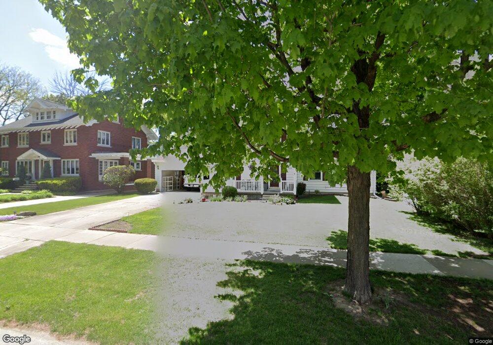
268 Sheridan Rd Waterloo, IA 50701
Estimated Value: $257,000 - $279,653
4
Beds
3
Baths
1,836
Sq Ft
$146/Sq Ft
Est. Value
About This Home
This home is located at 268 Sheridan Rd, Waterloo, IA 50701 and is currently estimated at $267,413, approximately $145 per square foot. 268 Sheridan Rd is a home located in Black Hawk County with nearby schools including Kingsley Elementary School, Hoover Middle School, and West High School.
Ownership History
Date
Name
Owned For
Owner Type
Purchase Details
Closed on
Jul 7, 2011
Sold by
Phh Mortgage Corp
Bought by
Secretary Of Housing And Urban Developme
Current Estimated Value
Purchase Details
Closed on
Jun 29, 2011
Sold by
Sparrow Kevin S and Sparrow Angela Suzette
Bought by
Phh Mortgage Corp
Purchase Details
Closed on
Jun 20, 2007
Sold by
Poparad Paul C and Poparad Mary Ann
Bought by
Reid Angela S and Sparrow Kevin S
Home Financials for this Owner
Home Financials are based on the most recent Mortgage that was taken out on this home.
Original Mortgage
$177,400
Interest Rate
6.54%
Mortgage Type
New Conventional
Create a Home Valuation Report for This Property
The Home Valuation Report is an in-depth analysis detailing your home's value as well as a comparison with similar homes in the area
Home Values in the Area
Average Home Value in this Area
Purchase History
| Date | Buyer | Sale Price | Title Company |
|---|---|---|---|
| Secretary Of Housing And Urban Developme | -- | None Available | |
| Phh Mortgage Corp | $195,281 | None Available | |
| Reid Angela S | $177,500 | None Available |
Source: Public Records
Mortgage History
| Date | Status | Borrower | Loan Amount |
|---|---|---|---|
| Previous Owner | Reid Angela S | $177,400 |
Source: Public Records
Tax History Compared to Growth
Tax History
| Year | Tax Paid | Tax Assessment Tax Assessment Total Assessment is a certain percentage of the fair market value that is determined by local assessors to be the total taxable value of land and additions on the property. | Land | Improvement |
|---|---|---|---|---|
| 2025 | $4,858 | $271,160 | $30,600 | $240,560 |
| 2024 | $4,858 | $247,910 | $30,600 | $217,310 |
| 2023 | $4,324 | $247,910 | $30,600 | $217,310 |
| 2022 | $4,208 | $205,740 | $30,600 | $175,140 |
| 2021 | $4,336 | $205,740 | $30,600 | $175,140 |
| 2020 | $4,260 | $200,000 | $24,860 | $175,140 |
| 2019 | $4,260 | $200,000 | $24,860 | $175,140 |
| 2018 | $4,264 | $200,000 | $24,860 | $175,140 |
| 2017 | $4,398 | $200,000 | $24,860 | $175,140 |
| 2016 | $4,340 | $200,000 | $24,860 | $175,140 |
| 2015 | $4,340 | $200,000 | $24,860 | $175,140 |
| 2014 | $4,210 | $190,790 | $24,860 | $165,930 |
Source: Public Records
Map
Nearby Homes
- 250 Sheridan Rd
- 3024 W 4th St
- Lot 6 Fischer Dr
- 1132 W Ridgeway Ave
- Lot 10 Paradise Estates First Addition
- Lot 44 Paradise Estates First Addition
- Lot 29 Paradise Estates First Addition
- Lot 1
- Lot 27 Paradise Estates First Addition
- Lot 54 Paradise Estates First Addition
- Lot 63 Paradise Estates First Addition
- Lot 39 Paradise Estates First Addition
- Lot 42 Paradise Estates First Addition
- Lot 13 Paradise Estates First Addition
- Lot 41 Paradise Estates First Addition
- Lot 14 Paradise Estates First Addition
- Lot 61 Paradise Estates First Addition
- Lot 53 Paradise Estates First Addition
- Lot 55 Paradise Estates First Addition
- Lot 9 Paradise Estates First Addition
- 260 Sheridan Rd
- 270 Sheridan Rd
- 277 Sheridan Rd
- 256 Sheridan Rd
- 284 Sheridan Rd
- 263 Sheridan Rd
- 199 Hampshire Rd
- 191 Hampshire Rd
- 219 Berkshire Rd
- 255 Sheridan Rd
- 296 Sheridan Rd
- 179 Hampshire Rd
- 227 Berkshire Rd
- 237 Berkshire Rd
- 247 Sheridan Rd
- 730 Prospect Blvd
- 240 Sheridan Rd
- 720 Prospect Blvd
- 245 Sheridan Rd
- 232 Sheridan Rd