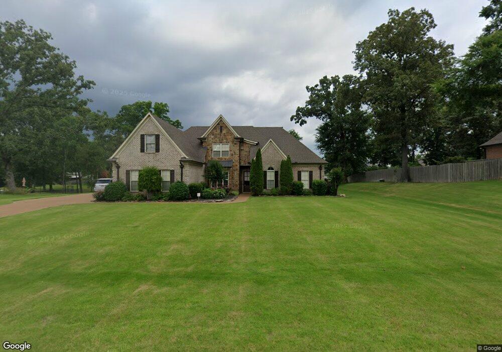
2682 Atticus Ln Nesbit, MS 38651
Pleasant Hill NeighborhoodEstimated Value: $504,000 - $647,000
5
Beds
4
Baths
4,021
Sq Ft
$144/Sq Ft
Est. Value
About This Home
This home is located at 2682 Atticus Ln, Nesbit, MS 38651 and is currently estimated at $577,785, approximately $143 per square foot. 2682 Atticus Ln is a home located in DeSoto County with nearby schools including DeSoto Central Primary School, DeSoto Central Elementary School, and DeSoto Central Middle School.
Ownership History
Date
Name
Owned For
Owner Type
Purchase Details
Closed on
Sep 7, 2012
Sold by
Pond Joseph A and Pond Elizabeth
Bought by
Pond Elizabeth
Current Estimated Value
Purchase Details
Closed on
Apr 23, 2010
Sold by
Jonathan Burch Construction Llc
Bought by
Pond Joseph A and Pond Elizabeth
Home Financials for this Owner
Home Financials are based on the most recent Mortgage that was taken out on this home.
Original Mortgage
$276,000
Outstanding Balance
$181,841
Interest Rate
4.94%
Mortgage Type
New Conventional
Estimated Equity
$395,944
Purchase Details
Closed on
Feb 9, 2009
Sold by
Burch Oliver M
Bought by
Jonathan Burch Construction Llc
Home Financials for this Owner
Home Financials are based on the most recent Mortgage that was taken out on this home.
Original Mortgage
$344,058
Interest Rate
5.08%
Mortgage Type
Credit Line Revolving
Create a Home Valuation Report for This Property
The Home Valuation Report is an in-depth analysis detailing your home's value as well as a comparison with similar homes in the area
Home Values in the Area
Average Home Value in this Area
Purchase History
| Date | Buyer | Sale Price | Title Company |
|---|---|---|---|
| Pond Elizabeth | -- | None Available | |
| Pond Joseph A | -- | First National Title Llc | |
| Jonathan Burch Construction Llc | -- | None Available |
Source: Public Records
Mortgage History
| Date | Status | Borrower | Loan Amount |
|---|---|---|---|
| Open | Pond Joseph A | $276,000 | |
| Closed | Pond Joseph A | $276,000 | |
| Previous Owner | Jonathan Burch Construction Llc | $344,058 |
Source: Public Records
Tax History
| Year | Tax Paid | Tax Assessment Tax Assessment Total Assessment is a certain percentage of the fair market value that is determined by local assessors to be the total taxable value of land and additions on the property. | Land | Improvement |
|---|---|---|---|---|
| 2025 | $3,119 | $40,955 | $5,000 | $35,955 |
| 2024 | $2,719 | $29,901 | $5,000 | $24,901 |
| 2023 | $2,719 | $29,901 | $0 | $0 |
| 2022 | $2,719 | $29,901 | $5,000 | $24,901 |
| 2021 | $2,719 | $29,901 | $5,000 | $24,901 |
| 2020 | $2,518 | $27,910 | $5,000 | $22,910 |
| 2019 | $2,518 | $27,910 | $5,000 | $22,910 |
| 2017 | $2,495 | $49,956 | $27,478 | $22,478 |
| 2016 | $2,656 | $29,066 | $5,000 | $24,066 |
| 2015 | $2,956 | $53,132 | $29,066 | $24,066 |
| 2014 | $2,627 | $29,066 | $0 | $0 |
| 2013 | $2,927 | $29,066 | $0 | $0 |
Source: Public Records
Map
Nearby Homes
- 1768 Linden Dr
- 3456 Susie Cir
- 401 Getwell Rd
- 403 Getwell Rd
- 3491 Hatton Dr
- 3040 Highground Dr
- 2768 Black Rock Rd
- 3505 Kreunen St
- 3250 W Hartland Dr
- 3621 Hatton Dr
- 1777 Starlanding Rd E
- 3622 Hatton Dr
- 2919 S Cherry Dr
- 2225 Highground Dr
- 4055 Bakersfield Dr
- 3617 Kreunen St
- 3631 Kreunen St
- 2951 Eden Ln
- 1811 Baisley Dr
- 1835 Baisley Dr
Your Personal Tour Guide
Ask me questions while you tour the home.