Estimated Value: $358,000 - $757,000
2
Beds
1
Bath
672
Sq Ft
$739/Sq Ft
Est. Value
About This Home
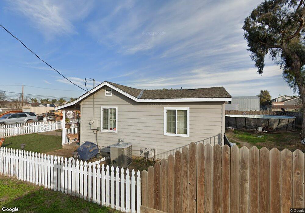
This home is located at 2684 W Byron Rd, Tracy, CA 95377 and is currently estimated at $496,819, approximately $739 per square foot. 2684 W Byron Rd is a home located in San Joaquin County with nearby schools including Melville S. Jacobson Elementary School, Monte Vista Middle School, and Merrill F. West High School.
Ownership History
Date
Name
Owned For
Owner Type
Purchase Details
Closed on
Dec 24, 2008
Sold by
Hellwig Vernon and Hellwig Marjorie A
Bought by
Oconnor Justin I
Current Estimated Value
Home Financials for this Owner
Home Financials are based on the most recent Mortgage that was taken out on this home.
Original Mortgage
$114,000
Outstanding Balance
$75,215
Interest Rate
6.1%
Mortgage Type
Seller Take Back
Estimated Equity
$421,604
Purchase Details
Closed on
Oct 6, 2008
Sold by
Rhoades Tamara
Bought by
Hellwig Vernon and Hellwig Marjorie A
Create a Home Valuation Report for This Property
The Home Valuation Report is an in-depth analysis detailing your home's value as well as a comparison with similar homes in the area
Home Values in the Area
Average Home Value in this Area
Purchase History
| Date | Buyer | Sale Price | Title Company |
|---|---|---|---|
| Oconnor Justin I | $118,000 | None Available | |
| Hellwig Vernon | $170,000 | None Available |
Source: Public Records
Mortgage History
| Date | Status | Borrower | Loan Amount |
|---|---|---|---|
| Open | Oconnor Justin I | $114,000 |
Source: Public Records
Tax History
| Year | Tax Paid | Tax Assessment Tax Assessment Total Assessment is a certain percentage of the fair market value that is determined by local assessors to be the total taxable value of land and additions on the property. | Land | Improvement |
|---|---|---|---|---|
| 2025 | $2,639 | $109,447 | $45,066 | $64,381 |
| 2024 | $2,573 | $107,302 | $44,183 | $63,119 |
| 2023 | $2,515 | $105,199 | $43,317 | $61,882 |
| 2022 | $2,439 | $103,137 | $42,468 | $60,669 |
| 2021 | $2,457 | $101,116 | $41,636 | $59,480 |
| 2020 | $2,405 | $100,081 | $41,210 | $58,871 |
| 2019 | $2,425 | $98,119 | $40,402 | $57,717 |
| 2018 | $2,390 | $96,196 | $39,610 | $56,586 |
| 2017 | $2,218 | $94,311 | $38,834 | $55,477 |
| 2016 | $2,268 | $92,463 | $38,073 | $54,390 |
| 2014 | $2,212 | $89,291 | $36,767 | $52,524 |
Source: Public Records
Map
Nearby Homes
- 1677 Green Springs Ct
- 1572 Cole Ln
- 2902 Campbell Ln
- 2919 Kennsington Ln
- 2488 Gaines Ln
- 1385 Lankershire Dr
- 2431 Ogden Sannazor Ct
- 1294 Dover Ln
- 3030 W Byron Rd
- 1214 Dover Ln
- 2306 Sabrina Way
- 2963 Rugby Ct
- 1233 Plaza Ct
- 3251 Milton Jenson Way
- 2231 Hillcrest Dr
- 2431 Garrett Ct
- 2689 Jackson Ave
- 1890 Spring Valley Way
- 2219 Yellowstone Ave
- 481 Keys Ct
- 2686 W Byron Rd
- 2710 W Byron Rd
- 2726 W Byron Rd
- 2718 W Byron Rd
- 2650 W Byron Rd
- 2734 W Byron Rd
- 2679 Gaines Ct
- 2748 W Byron Rd
- 2669 Gaines Ct
- 1540 Bernard Phelan Ave
- 1550 Bernard Phelan Ave
- 1530 Bernard Phelan Ave
- 1560 Bernard Phelan Ave
- 2678 Gaines Ct
- 1520 Bernard Phelan Ave
- 2659 Gaines Ct
- 1510 Bernard Phelan Ave
- 1570 Bernard Phelan Ave
- 1580 Bernard Phelan Ave
- 1381 Berg Rd
Your Personal Tour Guide
Ask me questions while you tour the home.