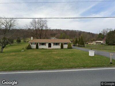
2685 Route 737 Kempton, PA 19529
Estimated Value: $289,000 - $330,000
2
Beds
2
Baths
1,128
Sq Ft
$270/Sq Ft
Est. Value
About This Home
This home is located at 2685 Route 737, Kempton, PA 19529 and is currently estimated at $304,559, approximately $269 per square foot. 2685 Route 737 is a home located in Berks County with nearby schools including Kutztown Area Senior High School.
Ownership History
Date
Name
Owned For
Owner Type
Purchase Details
Closed on
May 21, 2021
Sold by
Fetherolf Barry L and Fetherolf Bobby L
Bought by
Lumsden Cedric A and Lumsden Janice D
Current Estimated Value
Home Financials for this Owner
Home Financials are based on the most recent Mortgage that was taken out on this home.
Original Mortgage
$176,250
Outstanding Balance
$150,348
Interest Rate
3.1%
Mortgage Type
New Conventional
Estimated Equity
$159,794
Purchase Details
Closed on
Aug 26, 1977
Bought by
Fetherolf Frank A and Fetherolf Clara L
Create a Home Valuation Report for This Property
The Home Valuation Report is an in-depth analysis detailing your home's value as well as a comparison with similar homes in the area
Home Values in the Area
Average Home Value in this Area
Purchase History
| Date | Buyer | Sale Price | Title Company |
|---|---|---|---|
| Lumsden Cedric A | $235,000 | First United Land Transfer I | |
| Fetherolf Frank A | -- | -- |
Source: Public Records
Mortgage History
| Date | Status | Borrower | Loan Amount |
|---|---|---|---|
| Open | Lumsden Cedric A | $176,250 | |
| Previous Owner | Fetherolf Clara L | $274,500 |
Source: Public Records
Tax History Compared to Growth
Tax History
| Year | Tax Paid | Tax Assessment Tax Assessment Total Assessment is a certain percentage of the fair market value that is determined by local assessors to be the total taxable value of land and additions on the property. | Land | Improvement |
|---|---|---|---|---|
| 2025 | $1,040 | $108,200 | $31,100 | $77,100 |
| 2024 | $4,209 | $108,200 | $31,100 | $77,100 |
| 2023 | $4,134 | $108,200 | $31,100 | $77,100 |
| 2022 | $4,134 | $108,200 | $31,100 | $77,100 |
| 2021 | $4,134 | $108,200 | $31,100 | $77,100 |
| 2020 | $4,134 | $108,200 | $31,100 | $77,100 |
| 2019 | $4,134 | $108,200 | $31,100 | $77,100 |
| 2018 | $4,134 | $108,200 | $31,100 | $77,100 |
| 2017 | $4,104 | $108,200 | $31,100 | $77,100 |
| 2016 | $845 | $108,200 | $31,100 | $77,100 |
| 2015 | $845 | $108,200 | $31,100 | $77,100 |
| 2014 | $845 | $108,200 | $31,100 | $77,100 |
Source: Public Records
Map
Nearby Homes
- 3395 Pennsylvania 737
- 9644 Oakview Rd
- 572 Old U S 22
- 4202 New Smithville Rd
- 8083 Allemaengel Rd
- 7056 Behler Rd
- 0 Lutz Rd
- 333 New Bethel Church Rd
- 890 LOT 4 Long Lane Rd
- 7866 Brobst Hill Rd
- 57 Skyview Dr
- 116 Pheasant Dr
- 10 Pheasant Dr
- 1563 Old Route 22
- 8046 Blue Mountain House Rd
- 96 Penn St
- 70 Miller Rd
- 3965 Blacksmith Rd
- 0 Sechler Ct
- 7489 Springhouse Rd
- 2685 Route 737
- 1 Brigham Way
- 2653 Route 737
- 0 Brigham Way
- 2682 Route 737
- 2629 Route 737
- 8 Brigham Way
- 2609 Route 737
- 2709 Route 737
- 16 Brigham Way
- 2710 Route 737
- 7 Brigham Way
- 5 Brigham Way
- 29 Brigham Way
- 2582 Route 737
- 2581 Route 737
- 2553 Route 737
- 2719 Pennsylvania 737
- 2556 Route 737
- 43 Brigham Way