Estimated Value: $887,601 - $1,075,000
3
Beds
2
Baths
1,335
Sq Ft
$732/Sq Ft
Est. Value
About This Home
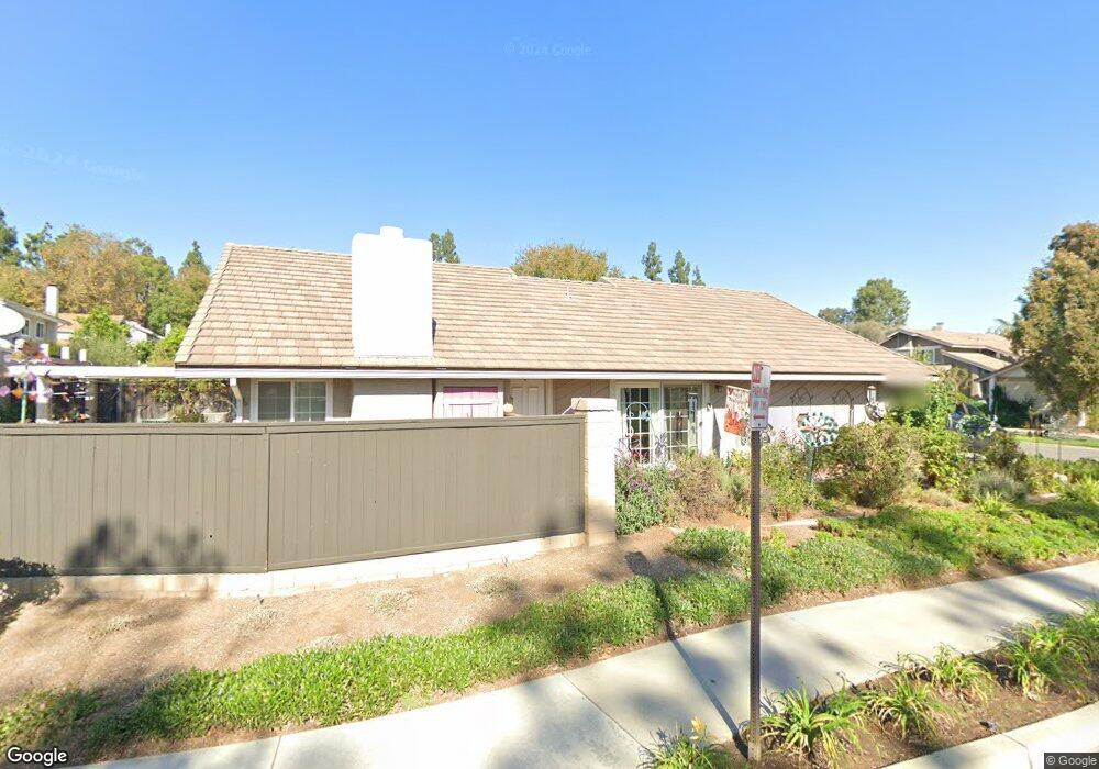
This home is located at 269 Cattail Cir, Brea, CA 92821 and is currently estimated at $977,400, approximately $732 per square foot. 269 Cattail Cir is a home located in Orange County with nearby schools including Brea Country Hills Elementary School, Brea Junior High School, and Brea-Olinda High School.
Ownership History
Date
Name
Owned For
Owner Type
Purchase Details
Closed on
May 15, 1997
Sold by
Murphy David R and Murphy Angelina T
Bought by
Stamant Joseph and Stamant Bonnie
Current Estimated Value
Home Financials for this Owner
Home Financials are based on the most recent Mortgage that was taken out on this home.
Original Mortgage
$163,900
Interest Rate
7.49%
Create a Home Valuation Report for This Property
The Home Valuation Report is an in-depth analysis detailing your home's value as well as a comparison with similar homes in the area
Home Values in the Area
Average Home Value in this Area
Purchase History
| Date | Buyer | Sale Price | Title Company |
|---|---|---|---|
| Stamant Joseph | $205,000 | Lawyers Title Company |
Source: Public Records
Mortgage History
| Date | Status | Borrower | Loan Amount |
|---|---|---|---|
| Previous Owner | Stamant Joseph | $163,900 | |
| Closed | Stamant Joseph | $30,700 |
Source: Public Records
Tax History
| Year | Tax Paid | Tax Assessment Tax Assessment Total Assessment is a certain percentage of the fair market value that is determined by local assessors to be the total taxable value of land and additions on the property. | Land | Improvement |
|---|---|---|---|---|
| 2025 | $3,844 | $327,323 | $174,369 | $152,954 |
| 2024 | $3,844 | $320,905 | $170,950 | $149,955 |
| 2023 | $3,736 | $314,613 | $167,598 | $147,015 |
| 2022 | $3,696 | $308,445 | $164,312 | $144,133 |
| 2021 | $3,627 | $302,398 | $161,091 | $141,307 |
| 2020 | $3,602 | $299,298 | $159,439 | $139,859 |
| 2019 | $3,509 | $293,430 | $156,313 | $137,117 |
| 2018 | $3,455 | $287,677 | $153,248 | $134,429 |
| 2017 | $3,390 | $282,037 | $150,243 | $131,794 |
| 2016 | $3,323 | $276,507 | $147,297 | $129,210 |
| 2015 | $3,276 | $272,354 | $145,084 | $127,270 |
| 2014 | $3,181 | $267,019 | $142,242 | $124,777 |
Source: Public Records
Map
Nearby Homes
- 2050 Fallingleaf Cir
- 2304 Carrotwood Dr
- 688 Buttonwood Dr
- 1941 Hillhaven Dr
- 2363 Morning Dew Dr
- 1796 Ravencrest Dr
- 2488 E Kern River Ln
- 648 Pepperwood Dr
- 360 Meadow Ct
- 2583 Sandpebble Ln
- 329 Surry Ct
- 38 Rogers Ct
- 145 S Poplar Ave Unit 20
- 2498 E Santa Paula Dr
- 232 Dale Ct
- 149 Spring Ct
- 127 S Redwood Ave
- 878 N Landa Way
- 2851 Rolling Hills Dr Unit 257
- 2851 Rolling Hills Dr Unit 248
- 275 Cattail Cir
- 281 Cattail Cir
- 276 Heathcliff Place
- 282 Heathcliff Place
- 287 Cattail Cir
- 263 Singingwood Ln
- 268 Cattail Cir
- 1770 Cloverdale Dr
- 274 Cattail Cir
- 288 Heathcliff Place
- 280 Cattail Cir
- 293 Cattail Cir
- 257 Singingwood Ln
- 1764 Cloverdale Dr
- 286 Cattail Cir
- 294 Heathcliff Place
- 292 Cattail Cir
- 251 Singingwood Ln
- 1758 Cloverdale Dr
- 271 Creekwood Ct
Your Personal Tour Guide
Ask me questions while you tour the home.