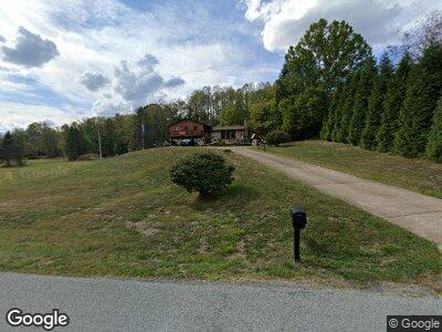
269 Fryes Rd Ruffs Dale, PA 15679
South Huntingdon Township NeighborhoodEstimated Value: $104,649 - $331,000
--
Bed
--
Bath
1,458
Sq Ft
$161/Sq Ft
Est. Value
About This Home
This home is located at 269 Fryes Rd, Ruffs Dale, PA 15679 and is currently estimated at $234,912, approximately $161 per square foot. 269 Fryes Rd is a home located in Westmoreland County with nearby schools including Mendon Elementary School, Yough Intermediate Middle School, and Yough Senior High School.
Ownership History
Date
Name
Owned For
Owner Type
Purchase Details
Closed on
Jul 25, 2008
Sold by
Fullman Irene
Bought by
Fullman David
Current Estimated Value
Purchase Details
Closed on
Sep 15, 2006
Sold by
King Charles L and King Gerri L
Bought by
Fullman David and Fullman Monica
Create a Home Valuation Report for This Property
The Home Valuation Report is an in-depth analysis detailing your home's value as well as a comparison with similar homes in the area
Home Values in the Area
Average Home Value in this Area
Purchase History
| Date | Buyer | Sale Price | Title Company |
|---|---|---|---|
| Fullman David | -- | None Available | |
| Fullman David | $8,500 | None Available |
Source: Public Records
Mortgage History
| Date | Status | Borrower | Loan Amount |
|---|---|---|---|
| Open | Fullman David | $60,000 | |
| Previous Owner | Fullman David J | $20,099 |
Source: Public Records
Tax History Compared to Growth
Tax History
| Year | Tax Paid | Tax Assessment Tax Assessment Total Assessment is a certain percentage of the fair market value that is determined by local assessors to be the total taxable value of land and additions on the property. | Land | Improvement |
|---|---|---|---|---|
| 2025 | $3,470 | $27,800 | $1,870 | $25,930 |
| 2024 | $3,470 | $27,800 | $1,870 | $25,930 |
| 2023 | $3,276 | $27,800 | $1,870 | $25,930 |
| 2022 | $3,220 | $27,800 | $1,870 | $25,930 |
| 2021 | $3,220 | $27,800 | $1,870 | $25,930 |
| 2020 | $3,220 | $27,800 | $1,870 | $25,930 |
| 2019 | $3,206 | $27,800 | $1,870 | $25,930 |
| 2018 | $3,206 | $27,800 | $1,870 | $25,930 |
| 2017 | $3,121 | $27,800 | $1,870 | $25,930 |
| 2016 | $2,851 | $27,800 | $1,870 | $25,930 |
| 2015 | $2,851 | $27,800 | $1,870 | $25,930 |
| 2014 | $2,790 | $27,800 | $1,870 | $25,930 |
Source: Public Records
Map
Nearby Homes
- 165 Manns Rd
- 623 Mount Nebo Church Rd
- 293 Malone Rd
- 265 State Route 31
- 1900 W Park Rd
- 1354 W Pittsburgh St
- 219 Edsel Dr
- 776 Pennsylvania 31
- 737 Buttermore Rd
- 768 State Route 31
- 0 Hunter Dr
- 305 Hunter Dr
- 2 Grace Rd
- 912 Maple St
- 153 Eagle Ct
- 0 Love and Emory Hill Rd
- 915 Mulberry St
- 716 Stauffer Ave
- 809 Arthur Ave
- 901 Pittsburgh St
- 269 Fryes Rd
- 281 Fryes Rd
- 247 Fryes Rd
- 219 Fryes Rd
- 699 Wesley Chapel Rd
- 330 Storey Frye Rd
- 1720 State Route 981
- 1720 State Route 981
- 1720 State Route 981
- 1720 State Route 981
- 1702 State Route 981
- 697 Wesley Chapel Rd
- 1728 State Route 981 Unit 843
- 1728 State Route 981 Unit 843
- 1701 State Route 981
- 1727 State Route 981
- 629 Wesley Chapel Rd
- 1738 State Route 981
- 104 Manns Rd
- 739 Wesley Chapel Rd