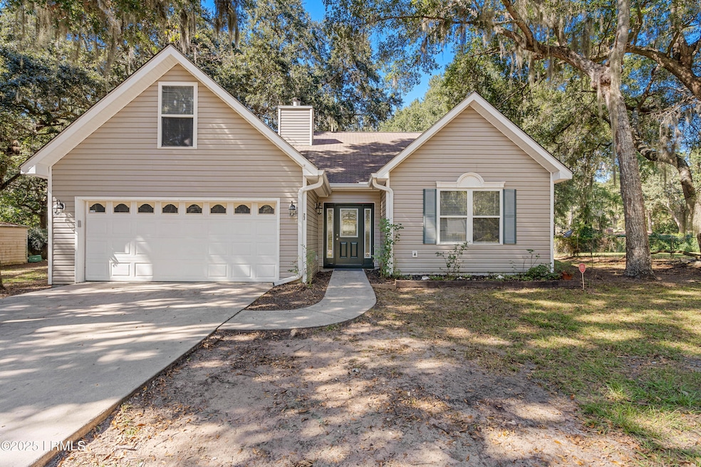


27 Ashley Dr Beaufort, SC 29907
Highlights
- Popular Property
- Ranch Style House
- No HOA
- Recreation Room
- Sun or Florida Room
- Porch
About This Home
Looking for a home with a 2-car garage on Lady's Island? This home checks every box: 2-car garage, 0.37-acre lot, bonus room, sunroom, fireplace, and a fenced yard—all at the best price available on Lady's Island in this category. Location, space, and versatility—all in one. No HOA. Flood insurance optional. Schedule an appointment today!

Open House Schedule
-
Sunday, March 15, 20261:00 to 4:00 pm3/15/2026 1:00:00 PM +00:003/15/2026 4:00:00 PM +00:00Add to Calendar
Home Details
Home Type
- Single Family
Year Built
- Built in 2001
Lot Details
- 0.37 Acre Lot
- Property is Fully Fenced
Parking
- 2 Car Garage
Home Design
- Ranch Style House
- Slab Foundation
- Composition Roof
- Vinyl Siding
Interior Spaces
- 1,894 Sq Ft Home
- Ceiling Fan
- Entrance Foyer
- Great Room with Fireplace
- Combination Kitchen and Dining Room
- Recreation Room
- Sun or Florida Room
Kitchen
- Electric Oven or Range
- Dishwasher
- Disposal
Flooring
- Partially Carpeted
- Laminate
- Tile
Bedrooms and Bathrooms
- 3 Bedrooms
- 2 Full Bathrooms
Laundry
- Dryer
- Washer
Outdoor Features
- Patio
- Rain Gutters
- Porch
Utilities
- Central Heating and Cooling System
- Air Source Heat Pump
- Vented Exhaust Fan
- Electric Water Heater
- Septic Tank
- Cable TV Available
Community Details
- No Home Owners Association
Listing and Financial Details
- Assessor Parcel Number R200 015 000 0755 0000
Map
Tax History
| Year | Tax Paid | Tax Assessment Tax Assessment Total Assessment is a certain percentage of the fair market value that is determined by local assessors to be the total taxable value of land and additions on the property. | Land | Improvement |
|---|---|---|---|---|
| 2025 | $4,199 | $15,490 | $0 | $0 |
| 2024 | $4,199 | $15,490 | $0 | $0 |
| 2023 | $4,132 | $15,490 | $0 | $0 |
| 2022 | $3,796 | $13,470 | $0 | $0 |
| 2021 | $3,680 | $13,470 | $0 | $0 |
| 2020 | $3,556 | $13,470 | $0 | $0 |
| 2019 | $3,509 | $13,470 | $0 | $0 |
| 2018 | $3,325 | $13,470 | $0 | $0 |
| 2017 | $3,097 | $12,040 | $0 | $0 |
| 2016 | $1,154 | $8,020 | $0 | $0 |
| 2014 | $944 | $8,020 | $0 | $0 |
Property History
| Date | Event | Price | List to Sale | Price per Sq Ft |
|---|---|---|---|---|
| 02/26/2026 02/26/26 | Price Changed | $380,000 | -4.8% | $201 / Sq Ft |
| 12/03/2025 12/03/25 | Price Changed | $399,000 | -5.0% | $211 / Sq Ft |
| 10/28/2025 10/28/25 | For Sale | $420,000 | -- | $222 / Sq Ft |
Purchase History
| Date | Type | Sale Price | Title Company |
|---|---|---|---|
| Interfamily Deed Transfer | $500 | None Available | |
| Warranty Deed | $247,000 | None Available | |
| Warranty Deed | $157,500 | -- |
Mortgage History
| Date | Status | Loan Amount | Loan Type |
|---|---|---|---|
| Open | $252,310 | VA | |
| Previous Owner | $141,750 | No Value Available |
Source: Lowcountry Regional MLS
MLS Number: 193151
APN: R200-015-000-0755-0000
Disclaimer: Certain information contained herein is derived from information provided by parties other than Homes.com. All information provided is deemed reliable, but is not guaranteed to be accurate and should be independently verified.
![]() IDX information is provided exclusively for personal, non-commercial use, and may not be used for any purpose other than to identify prospective properties consumers may be interested in purchasing. Information is deemed reliable but not guaranteed.
IDX information is provided exclusively for personal, non-commercial use, and may not be used for any purpose other than to identify prospective properties consumers may be interested in purchasing. Information is deemed reliable but not guaranteed.
- 8 Factory Creek Rd
- 32 Ashley Dr
- 4250 Sage Dr
- 4230 Sage Dr
- 7 Woodbine Dr
- 8 Blythewood Rd
- 25 Miller Dr W
- 11 Wiggins Rd
- 3635 Oyster Bluff Dr
- 3674 Oyster Bluff Dr
- 4100 Sage Dr
- 12 Bent Oak Rd
- 3754 Oyster Bluff Dr
- 7 Basin Trail St
- 11 Shiloh Ct
- 15 Shiloh Ct
- 1 Shallow Run Ln
- 31 Shorts Landing Rd
- 5 Indigo Bay Ln
- 15 Hilda Ave
- 21 Waterside Dr
- 2 Island Breeze Ln
- 22 Colony Gardens Rd
- 714 Adventure St
- 4 Turtle Ln
- 607 Waight St
- 164 James St
- 120 Elliott St
- 2305 Pine Ct S
- 1231 Ladys Island Dr Unit 236
- 2205 Southside Blvd Unit 5b
- 2208 Southside Blvd
- 2678 Broad St
- 2701 Southside Blvd
- 661 Sams Point Rd
- 2912 Third St
- 2723 Waddell Rd
- 1 Preserve Ave W
- 900 Brotherhood Rd Unit G4
- 2000 Salem Rd
Ask me questions while you tour the home.