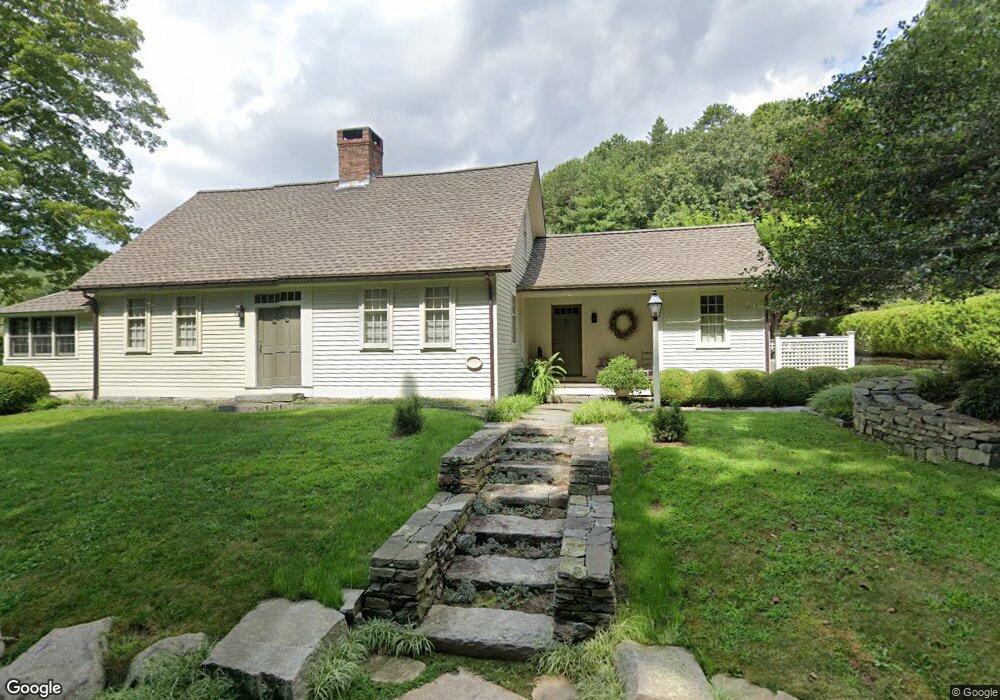
27 Brockway Ferry Rd Old Lyme, CT 06371
Estimated Value: $1,341,000 - $1,748,000
3
Beds
4
Baths
1,410
Sq Ft
$1,114/Sq Ft
Est. Value
About This Home
This home is located at 27 Brockway Ferry Rd, Old Lyme, CT 06371 and is currently estimated at $1,570,955, approximately $1,114 per square foot. 27 Brockway Ferry Rd is a home located in New London County with nearby schools including Lyme Consolidated School, Lyme-Old Lyme Middle School, and Lyme-Old Lyme High School.
Ownership History
Date
Name
Owned For
Owner Type
Purchase Details
Closed on
Mar 6, 2017
Sold by
Angers Thomas E
Bought by
Angers Thomas E and Vandaff Timothy S
Current Estimated Value
Purchase Details
Closed on
Mar 14, 2011
Sold by
Lieber William A and Lieber Caroyn D
Bought by
Angers Thomas E
Home Financials for this Owner
Home Financials are based on the most recent Mortgage that was taken out on this home.
Original Mortgage
$864,000
Interest Rate
4.83%
Purchase Details
Closed on
Feb 26, 1999
Sold by
Clements Nicholas
Bought by
Lieber William A and Lieber Carolyn D
Create a Home Valuation Report for This Property
The Home Valuation Report is an in-depth analysis detailing your home's value as well as a comparison with similar homes in the area
Home Values in the Area
Average Home Value in this Area
Purchase History
| Date | Buyer | Sale Price | Title Company |
|---|---|---|---|
| Angers Thomas E | -- | -- | |
| Angers Thomas E | $1,080,000 | -- | |
| Lieber William A | $370,000 | -- |
Source: Public Records
Mortgage History
| Date | Status | Borrower | Loan Amount |
|---|---|---|---|
| Previous Owner | Lieber William A | $864,000 | |
| Previous Owner | Lieber William A | $864,000 | |
| Previous Owner | Lieber William A | $250,000 | |
| Previous Owner | Lieber William A | $60,000 |
Source: Public Records
Tax History Compared to Growth
Tax History
| Year | Tax Paid | Tax Assessment Tax Assessment Total Assessment is a certain percentage of the fair market value that is determined by local assessors to be the total taxable value of land and additions on the property. | Land | Improvement |
|---|---|---|---|---|
| 2025 | $13,001 | $896,614 | $241,714 | $654,900 |
| 2024 | $13,001 | $896,614 | $241,714 | $654,900 |
| 2023 | $13,238 | $678,878 | $172,278 | $506,600 |
| 2022 | $13,544 | $678,878 | $172,278 | $506,600 |
| 2021 | $10,145 | $678,878 | $172,278 | $506,600 |
| 2020 | $13,544 | $678,878 | $172,278 | $506,600 |
| 2019 | $13,544 | $678,878 | $172,278 | $506,600 |
| 2018 | $13,180 | $708,605 | $221,505 | $487,100 |
| 2017 | $12,932 | $708,605 | $221,505 | $487,100 |
| 2016 | $12,932 | $708,605 | $221,505 | $487,100 |
| 2015 | $12,578 | $708,605 | $221,505 | $487,100 |
| 2014 | $12,046 | $708,605 | $221,505 | $487,100 |
Source: Public Records
Map
Nearby Homes
- 274 Joshuatown Rd
- 41 Joshua Ln
- 155 Joshuatown Rd
- 17 Lookout Hill
- 41B River Rd
- 132 Tantumorantum Rd
- 153 Mitchell Hill Rd
- 85 River Rd Unit B7
- 85 River Rd Unit J6
- 89 Brush Hill Rd
- 117 Elys Ferry Rd
- 109 Elys Ferry Rd
- 95 Cove Rd
- 66 Cove Rd
- 89 Book Hill Rd
- 7 Foxboro Rd
- 1 Foxboro Rd
- 53 Elys Ferry Rd
- 13 Maple Ave
- 14 Ferry Rd Unit E2
- 41 Brockway Ferry Rd
- 18 Brockway Ferry Rd
- 40 Brockway Ferry Rd
- 30-1 Brockway Ferry Rd
- 218 Joshuatown Rd
- 228 Joshuatown Rd
- 250 Joshuatown Rd
- 4 Brockway Ferry Rd
- 244 Joshuatown Rd
- 258 Joshuatown Rd
- 44 Brockway Ferry Rd
- 30-2 Brockway Ferry Rd
- 48 Brockway Ferry Rd
- 30 Brockway Ferry Rd Unit B
- 30 Brockway Ferry Rd Unit A
- 30 Brockway Ferry Rd
- 34 Brockway Ferry Rd
- 70 Brockway Ferry Rd
- 68 Brockway Ferry Rd
- 52 Brockway Ferry Rd