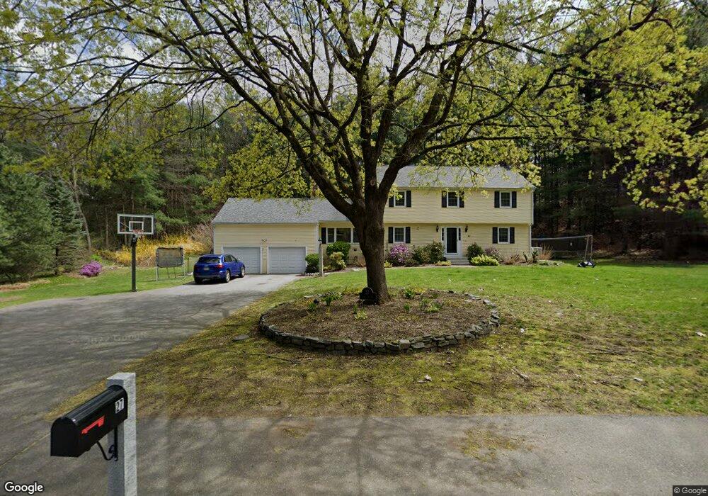
27 Lands End Ln Sudbury, MA 01776
Estimated Value: $1,108,980 - $1,285,000
4
Beds
3
Baths
2,246
Sq Ft
$538/Sq Ft
Est. Value
About This Home
This home is located at 27 Lands End Ln, Sudbury, MA 01776 and is currently estimated at $1,207,495, approximately $537 per square foot. 27 Lands End Ln is a home located in Middlesex County with nearby schools including Israel Loring Elementary School, Ephraim Curtis Middle School, and Lincoln-Sudbury Regional High School.
Ownership History
Date
Name
Owned For
Owner Type
Purchase Details
Closed on
Aug 20, 2020
Sold by
Morrissey Bonnie K
Bought by
Morrissey Scott A and Morrissey Bonnie K
Current Estimated Value
Home Financials for this Owner
Home Financials are based on the most recent Mortgage that was taken out on this home.
Original Mortgage
$300,000
Outstanding Balance
$209,936
Interest Rate
3%
Mortgage Type
New Conventional
Estimated Equity
$997,559
Purchase Details
Closed on
Aug 2, 2001
Sold by
Horton Ronald C and Horton Linda A
Bought by
Morrissey Bonnie K
Home Financials for this Owner
Home Financials are based on the most recent Mortgage that was taken out on this home.
Original Mortgage
$359,000
Interest Rate
7.14%
Mortgage Type
Purchase Money Mortgage
Create a Home Valuation Report for This Property
The Home Valuation Report is an in-depth analysis detailing your home's value as well as a comparison with similar homes in the area
Home Values in the Area
Average Home Value in this Area
Purchase History
| Date | Buyer | Sale Price | Title Company |
|---|---|---|---|
| Morrissey Scott A | -- | None Available | |
| Morrissey Scott A | -- | None Available | |
| Morrissey Bonnie K | $647,000 | -- |
Source: Public Records
Mortgage History
| Date | Status | Borrower | Loan Amount |
|---|---|---|---|
| Open | Morrissey Scott A | $300,000 | |
| Closed | Morrissey Scott A | $300,000 | |
| Previous Owner | Morrissey Bonnie K | $359,000 | |
| Previous Owner | Morrissey Bonnie K | $120,000 |
Source: Public Records
Tax History Compared to Growth
Tax History
| Year | Tax Paid | Tax Assessment Tax Assessment Total Assessment is a certain percentage of the fair market value that is determined by local assessors to be the total taxable value of land and additions on the property. | Land | Improvement |
|---|---|---|---|---|
| 2025 | $15,485 | $1,057,700 | $501,000 | $556,700 |
| 2024 | $14,921 | $1,021,300 | $486,600 | $534,700 |
| 2023 | $13,931 | $883,400 | $434,600 | $448,800 |
| 2022 | $13,857 | $767,700 | $398,600 | $369,100 |
| 2021 | $13,373 | $710,200 | $398,600 | $311,600 |
| 2020 | $13,103 | $710,200 | $398,600 | $311,600 |
| 2019 | $12,720 | $710,200 | $398,600 | $311,600 |
| 2018 | $12,723 | $709,600 | $424,200 | $285,400 |
| 2017 | $12,478 | $703,400 | $420,600 | $282,800 |
| 2016 | $12,097 | $679,600 | $404,600 | $275,000 |
| 2015 | $11,320 | $643,200 | $373,400 | $269,800 |
| 2014 | $11,301 | $626,800 | $362,300 | $264,500 |
Source: Public Records
Map
Nearby Homes
- 84 Hopestill Brown Rd
- 14 Eisenhower Rd
- 91 Eaton Rd W
- 19 Nob Hill Dr
- 0 Wagonwheel Rd
- 32 Eaton Rd W
- 63 Landham Rd
- 30 Nobscot Rd Unit 14
- 1011 Boston Post Rd
- 216 Landham Rd
- 30 Edith Rd
- 41 James St
- 40 Gregory Rd
- 53 Davidson Rd
- 78 Apple d or Rd
- 106 Baldwin Ave
- 24 Woodland Rd
- 23 Massasoit Ave
- 14 Francine Rd
- 36 Concord Rd
- 21 Lands End Ln
- 33 Lands End Ln
- 24 Lands End Ln
- 26 Lombard Ln
- 39 Lands End Ln
- 18 Lombard Ln
- 16 Lands End Ln
- 38 Lands End Ln
- 15 Lands End Ln
- 46 Lands End Ln
- 27 Lombard Ln
- 12 Lombard Ln
- 30 Robert Frost Rd
- 8 Lands End Ln
- 17 Lombard Ln
- 47 Lands End Ln
- 9 Lands End Ln
- 45 Rambling Rd
- 11 Lombard Ln
- 38 Robert Frost Rd