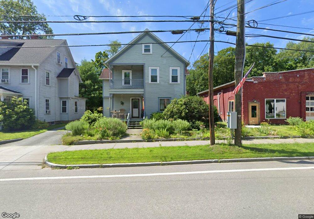
27 Main St Conway, MA 01341
Estimated Value: $290,000 - $394,000
3
Beds
2
Baths
1,488
Sq Ft
$221/Sq Ft
Est. Value
About This Home
This home is located at 27 Main St, Conway, MA 01341 and is currently estimated at $328,361, approximately $220 per square foot. 27 Main St is a home located in Franklin County with nearby schools including Frontier Regional School.
Ownership History
Date
Name
Owned For
Owner Type
Purchase Details
Closed on
Aug 12, 2011
Sold by
Foxton Erin and Morris Kipling T
Bought by
Llamas Robert F
Current Estimated Value
Purchase Details
Closed on
Jun 23, 2000
Sold by
Kiser Sally Jane
Bought by
Foxton Erin and Morris Kilping T
Home Financials for this Owner
Home Financials are based on the most recent Mortgage that was taken out on this home.
Original Mortgage
$75,400
Interest Rate
8.48%
Mortgage Type
Purchase Money Mortgage
Create a Home Valuation Report for This Property
The Home Valuation Report is an in-depth analysis detailing your home's value as well as a comparison with similar homes in the area
Home Values in the Area
Average Home Value in this Area
Purchase History
| Date | Buyer | Sale Price | Title Company |
|---|---|---|---|
| Llamas Robert F | $150,000 | -- | |
| Foxton Erin | $94,900 | -- |
Source: Public Records
Mortgage History
| Date | Status | Borrower | Loan Amount |
|---|---|---|---|
| Previous Owner | Foxton Erin | $87,000 | |
| Previous Owner | Foxton Erin | $75,400 | |
| Closed | Foxton Erin | $10,000 |
Source: Public Records
Tax History Compared to Growth
Tax History
| Year | Tax Paid | Tax Assessment Tax Assessment Total Assessment is a certain percentage of the fair market value that is determined by local assessors to be the total taxable value of land and additions on the property. | Land | Improvement |
|---|---|---|---|---|
| 2025 | $3,646 | $252,500 | $72,200 | $180,300 |
| 2024 | $3,454 | $210,600 | $65,600 | $145,000 |
| 2023 | $3,612 | $210,600 | $65,600 | $145,000 |
| 2022 | $3,500 | $195,000 | $60,700 | $134,300 |
| 2021 | $2,380 | $184,400 | $58,100 | $126,300 |
| 2020 | $3,257 | $173,600 | $58,200 | $115,400 |
| 2019 | $3,238 | $173,600 | $58,200 | $115,400 |
| 2018 | $2,152 | $170,900 | $58,200 | $112,700 |
| 2017 | $2,195 | $170,900 | $58,200 | $112,700 |
| 2016 | $2,650 | $158,900 | $50,800 | $108,100 |
| 2015 | $2,569 | $158,900 | $50,800 | $108,100 |
Source: Public Records
Map
Nearby Homes
- 14 River St
- 0 Pleasant St
- lot 1 Shelburne Falls Rd
- 71 Mathews Rd
- 85 Dacey Rd
- 473 N Poland Rd
- 30 Lee Rd
- 1531 Williamsburg Rd
- 240 Beldingville Rd
- 230 S Ashfield Rd
- 820 E Guinea Rd
- 345 Greenfield Rd
- 208 Greenfield Rd
- 24 Elm St
- 13 Capt Lathrop Dr
- 24 Graves St
- 32 Swamp Rd
- 33 Eastern Ave
- 0 North St Unit 73407299
- 15 Crestview Dr