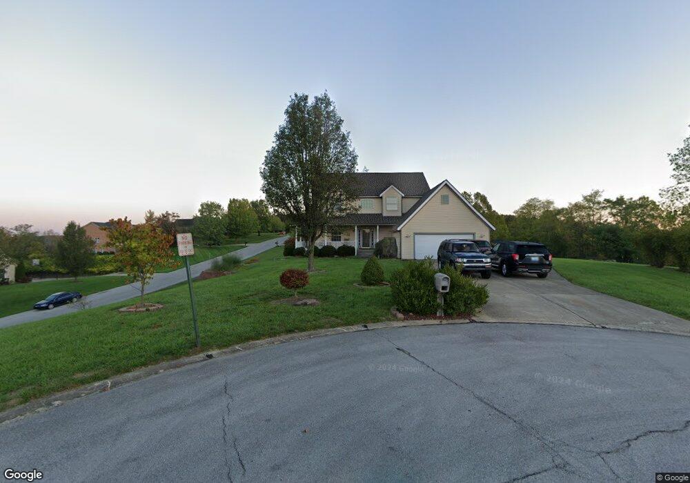
27 Maple Valley Ln Alexandria, KY 41001
Estimated Value: $389,000 - $509,000
3
Beds
4
Baths
2,256
Sq Ft
$198/Sq Ft
Est. Value
About This Home
This home is located at 27 Maple Valley Ln, Alexandria, KY 41001 and is currently estimated at $446,837, approximately $198 per square foot. 27 Maple Valley Ln is a home located in Campbell County with nearby schools including Campbell Ridge Elementary School, Campbell County Middle School, and Campbell County High School.
Ownership History
Date
Name
Owned For
Owner Type
Purchase Details
Closed on
Apr 14, 2020
Sold by
Bush Patrick H and Bush Patricia
Bought by
Kuth Ginger and Kuth Steve
Current Estimated Value
Purchase Details
Closed on
Mar 31, 2020
Sold by
Bush Patrick H and Bush Patricia
Bought by
Kuth Ginger and Kuth Steve
Purchase Details
Closed on
Aug 2, 2013
Sold by
Ward John Michael and Ward Carol A
Bought by
Bush Patrick H and Bush Patricia
Home Financials for this Owner
Home Financials are based on the most recent Mortgage that was taken out on this home.
Original Mortgage
$232,750
Interest Rate
3.96%
Mortgage Type
New Conventional
Purchase Details
Closed on
Jul 9, 1998
Sold by
B & S Dev Corp
Bought by
Ward John M and Ward Carol A
Create a Home Valuation Report for This Property
The Home Valuation Report is an in-depth analysis detailing your home's value as well as a comparison with similar homes in the area
Home Values in the Area
Average Home Value in this Area
Purchase History
| Date | Buyer | Sale Price | Title Company |
|---|---|---|---|
| Kuth Ginger | $270,000 | None Available | |
| Kuth Ginger | $270,000 | None Available | |
| Bush Patrick H | $245,000 | None Available | |
| Ward John M | $28,000 | -- |
Source: Public Records
Mortgage History
| Date | Status | Borrower | Loan Amount |
|---|---|---|---|
| Previous Owner | Bush Patrick H | $232,750 |
Source: Public Records
Tax History Compared to Growth
Tax History
| Year | Tax Paid | Tax Assessment Tax Assessment Total Assessment is a certain percentage of the fair market value that is determined by local assessors to be the total taxable value of land and additions on the property. | Land | Improvement |
|---|---|---|---|---|
| 2024 | $3,966 | $328,300 | $35,000 | $293,300 |
| 2023 | $3,874 | $328,300 | $35,000 | $293,300 |
| 2022 | $3,325 | $270,000 | $35,000 | $235,000 |
| 2021 | $3,364 | $270,000 | $35,000 | $235,000 |
| 2020 | $3,289 | $260,000 | $35,000 | $225,000 |
| 2019 | $3,258 | $260,000 | $35,000 | $225,000 |
| 2018 | $3,095 | $245,000 | $28,000 | $217,000 |
| 2017 | $3,061 | $245,000 | $28,000 | $217,000 |
| 2016 | $2,952 | $245,000 | $0 | $0 |
| 2015 | $3,021 | $245,000 | $0 | $0 |
| 2014 | $2,913 | $245,000 | $0 | $0 |
Source: Public Records
Map
Nearby Homes
- 1 Saddle Ridge Trail
- 0 Persimmon Grove Pike
- 1193 Edgewater Way
- 1194 Edgewater Way
- 4 Woodbury Ln
- 10061 Persimmon Grove Pike
- 113 Clearmeadow Dr
- 8 Driftwood Ct
- 1050 Lickert Rd
- 42 Ridgewood Dr
- 32 Bittersweet Dr
- 12 S Bellewood Ct
- 4 Fernwood Ct
- 2 S Bellewood Ct
- 33 Shaw Dr
- 16 Shaw Dr
- 10593 Lynn Ln Unit 1
- 9039 Oak Ln
- 9027 Oak Ln
- 716 Mallard Dr
- 36 Maple Valley Ln
- 16 Saddle Ridge Trail
- 11 Saddle Ridge Trail
- 13 Saddle Ridge Trail
- 34 Maple Valley Ln
- 18 Saddle Ridge Trail
- 25 Maple Valley Ln
- 9 Saddle Ridge Trail
- 15 Saddle Ridge Trail
- 20 Saddle Ridge Trail
- 23 Maple Valley Ln
- 32 Maple Valley Ln
- 17 Saddle Ridge Trail
- 7 Saddle Ridge Trail
- 21 Maple Valley Ln
- 30 Maple Valley Ln
- 12 Saddle Ridge Trail
- 10 Bridle Cove
- 5 Saddle Ridge Trail
- 10 Saddle Ridge Trail