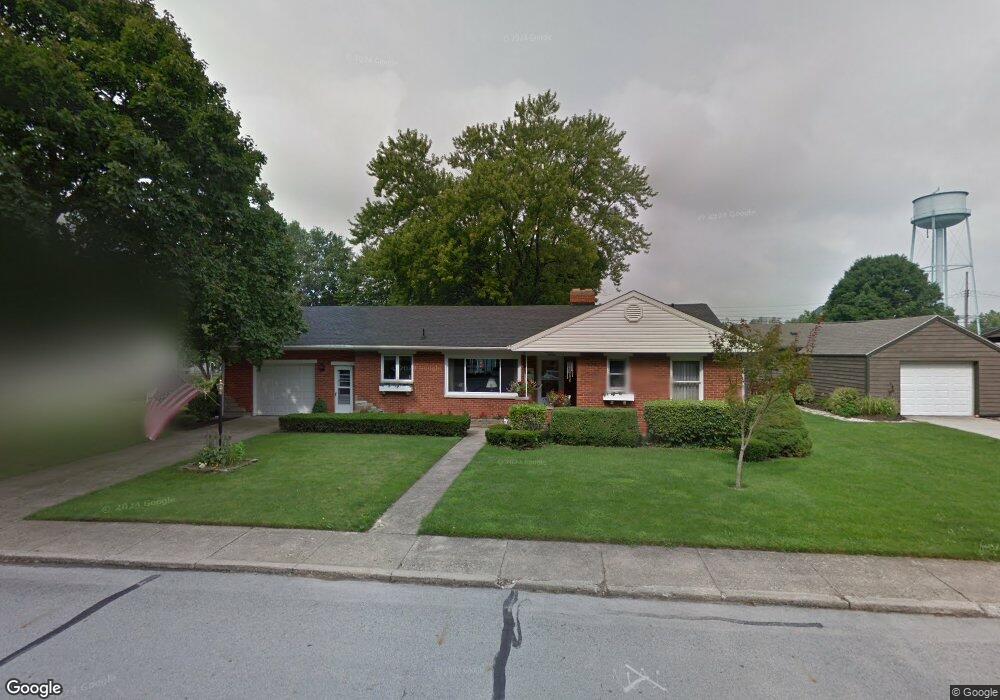
27 N Wenrick St Covington, OH 45318
Estimated Value: $227,000 - $262,000
3
Beds
2
Baths
1,712
Sq Ft
$146/Sq Ft
Est. Value
About This Home
This home is located at 27 N Wenrick St, Covington, OH 45318 and is currently estimated at $249,220, approximately $145 per square foot. 27 N Wenrick St is a home located in Miami County with nearby schools including Covington Elementary/Junior High School, Covington Junior High School, and Covington High School.
Ownership History
Date
Name
Owned For
Owner Type
Purchase Details
Closed on
Nov 16, 2005
Sold by
Kinney Doris L
Bought by
Angle Wayne F and Angle Karen K
Current Estimated Value
Purchase Details
Closed on
Dec 30, 2003
Sold by
Kinney James C
Bought by
Kinney Doris L
Purchase Details
Closed on
Jan 1, 1990
Bought by
Kinney James C
Create a Home Valuation Report for This Property
The Home Valuation Report is an in-depth analysis detailing your home's value as well as a comparison with similar homes in the area
Home Values in the Area
Average Home Value in this Area
Purchase History
| Date | Buyer | Sale Price | Title Company |
|---|---|---|---|
| Angle Wayne F | $145,000 | -- | |
| Kinney Doris L | -- | -- | |
| Kinney James C | -- | -- |
Source: Public Records
Tax History Compared to Growth
Tax History
| Year | Tax Paid | Tax Assessment Tax Assessment Total Assessment is a certain percentage of the fair market value that is determined by local assessors to be the total taxable value of land and additions on the property. | Land | Improvement |
|---|---|---|---|---|
| 2024 | $2,339 | $72,030 | $14,280 | $57,750 |
| 2023 | $2,339 | $72,030 | $14,280 | $57,750 |
| 2022 | $2,371 | $72,030 | $14,280 | $57,750 |
| 2021 | $1,890 | $55,410 | $10,990 | $44,420 |
| 2020 | $1,894 | $55,410 | $10,990 | $44,420 |
| 2019 | $1,903 | $55,410 | $10,990 | $44,420 |
| 2018 | $1,687 | $49,980 | $8,540 | $41,440 |
| 2017 | $1,716 | $49,980 | $8,540 | $41,440 |
| 2016 | $1,695 | $49,980 | $8,540 | $41,440 |
| 2015 | $1,550 | $48,060 | $8,230 | $39,830 |
| 2014 | $1,550 | $48,060 | $8,230 | $39,830 |
| 2013 | $1,492 | $48,060 | $8,230 | $39,830 |
Source: Public Records
Map
Nearby Homes
- 271 N Ludlow St
- 698 E Broadway St
- 00 W Piqua Clay Rd
- 223 Henry Ct
- 124 N Main St
- 221 S High St
- 536 S High St
- 212 Charles Ct
- 210 Charles Ct
- 206 Charles Ct
- 208 Charles Ct
- 204 Charles Ct
- 207 Charles Ct
- 205 Charles Ct
- 133 W Broadway St
- 203 Charles Ct
- 201 Charles Ct
- 202 Charles Ct
- 200 Charles Ct
- 219 Henry Ct
- 17 N Wenrick St
- 37 N Wenrick St
- 26 N Ludlow St
- 39 N Wenrick St
- 20 N Ludlow St
- 38 N Ludlow St
- 22 N Wenrick St
- 514 E Walnut St
- 524 E Walnut St
- 94 N Ludlow St
- 24 N Wenrick St
- 36 N Wenrick St
- 604 E Walnut St
- 40 N Wenrick St
- 504 E Walnut St
- 96 N Ludlow St
- 608 E Walnut St
- 409 E Maple St
- 0 S Wenrick St Unit 437194
- 0 S Wenrick St Unit 307511