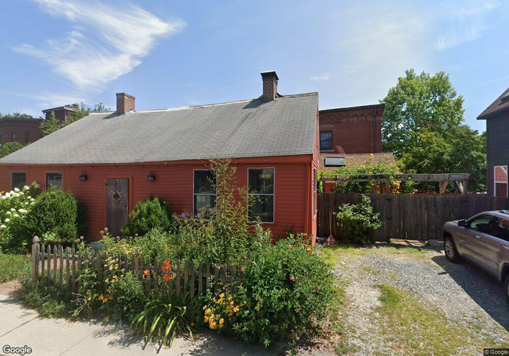
27 Pond St Amesbury, MA 01913
Estimated Value: $709,000 - $820,000
2
Beds
2
Baths
2,325
Sq Ft
$327/Sq Ft
Est. Value
About This Home
This home is located at 27 Pond St, Amesbury, MA 01913 and is currently estimated at $760,545, approximately $327 per square foot. 27 Pond St is a home located in Essex County with nearby schools including Amesbury High School and Amesbury Seventh-Day Adventist School.
Ownership History
Date
Name
Owned For
Owner Type
Purchase Details
Closed on
Oct 20, 2000
Sold by
Alders Ann L and Alders Robert G
Bought by
Gottwald Matthias G and Gottwald Stephanie L
Current Estimated Value
Home Financials for this Owner
Home Financials are based on the most recent Mortgage that was taken out on this home.
Original Mortgage
$108,700
Interest Rate
7.88%
Mortgage Type
Purchase Money Mortgage
Create a Home Valuation Report for This Property
The Home Valuation Report is an in-depth analysis detailing your home's value as well as a comparison with similar homes in the area
Home Values in the Area
Average Home Value in this Area
Purchase History
| Date | Buyer | Sale Price | Title Company |
|---|---|---|---|
| Gottwald Matthias G | $116,000 | -- |
Source: Public Records
Mortgage History
| Date | Status | Borrower | Loan Amount |
|---|---|---|---|
| Closed | Gottwald Matthias G | $143,100 | |
| Closed | Gottwald Matthias G | $149,500 | |
| Closed | Gottwald Matthias G | $50,000 | |
| Closed | Gottwald Matthias G | $108,700 |
Source: Public Records
Tax History Compared to Growth
Tax History
| Year | Tax Paid | Tax Assessment Tax Assessment Total Assessment is a certain percentage of the fair market value that is determined by local assessors to be the total taxable value of land and additions on the property. | Land | Improvement |
|---|---|---|---|---|
| 2025 | $9,338 | $610,300 | $193,900 | $416,400 |
| 2024 | $9,400 | $601,000 | $182,900 | $418,100 |
| 2023 | $8,319 | $509,100 | $159,000 | $350,100 |
| 2022 | $7,628 | $431,200 | $138,300 | $292,900 |
| 2021 | $7,342 | $402,300 | $106,800 | $295,500 |
| 2020 | $6,747 | $392,700 | $102,700 | $290,000 |
| 2019 | $6,720 | $365,800 | $102,700 | $263,100 |
| 2018 | $6,741 | $355,000 | $97,900 | $257,100 |
| 2017 | $5,817 | $291,600 | $97,900 | $193,700 |
| 2016 | $4,958 | $244,500 | $97,900 | $146,600 |
| 2015 | $4,936 | $240,300 | $97,900 | $142,400 |
| 2014 | $4,561 | $217,500 | $97,900 | $119,600 |
Source: Public Records
Map
Nearby Homes
- 37 Millyard Unit 204
- 17 Linwood Place
- 53 Market St
- 81 High St Unit 27
- 24 Aubin St Unit 2
- 4 Lincoln Ct
- 43 Aubin St Unit 1
- 19 Perkins St
- 5 Richs Ct Unit 3
- 13 Lincoln Ct
- 17 Lincoln Ct
- 48 Orchard St
- 97 Elm St
- 25 Cedar St Unit 4
- 25 Cedar St Unit 7
- 15 Sparhawk St Unit 3
- 101 Market St Unit B
- 101 Market St Unit A
- 103 Market St Unit A
- 103 Market St Unit B
- 31 Pond St
- 1 Short St Unit 1
- 1 Short St
- 3 Short St Unit 3
- 1 Short St
- 37 Millyard Unit 107
- 37 Millyard Unit 106
- 37 Millyard Unit 310
- 37 Millyard Unit 309
- 37 Millyard Unit 308
- 37 Millyard Unit 307
- 37 Millyard Unit 306
- 37 Millyard Unit 305
- 37 Millyard Unit 304
- 37 Millyard Unit 303
- 37 Millyard Unit 302
- 37 Millyard Unit 301
- 37 Millyard Unit 210
- 37 Millyard Unit 209
- 37 Millyard Unit 208