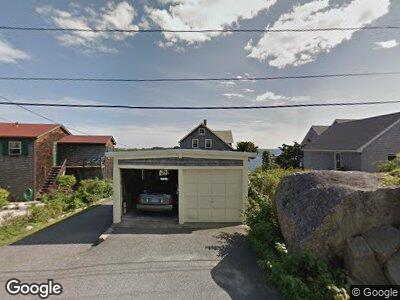
27 Salt Island Rd Gloucester, MA 01930
East Gloucester NeighborhoodEstimated Value: $947,000 - $2,512,000
4
Beds
2
Baths
1,574
Sq Ft
$1,155/Sq Ft
Est. Value
About This Home
This home is located at 27 Salt Island Rd, Gloucester, MA 01930 and is currently estimated at $1,818,154, approximately $1,155 per square foot. 27 Salt Island Rd is a home located in Essex County with nearby schools including East Gloucester Elementary School, Ralph B O'maley Middle School, and Gloucester High School.
Ownership History
Date
Name
Owned For
Owner Type
Purchase Details
Closed on
Feb 7, 2022
Sold by
Morgan Gary W
Bought by
Morgan Brenda L and Morgan Gary W
Current Estimated Value
Purchase Details
Closed on
Oct 22, 2018
Sold by
Morgan Lt
Bought by
Morgan Survivors T
Purchase Details
Closed on
Aug 24, 2016
Sold by
Benton-Morgan Albert
Bought by
Morgan Lt
Create a Home Valuation Report for This Property
The Home Valuation Report is an in-depth analysis detailing your home's value as well as a comparison with similar homes in the area
Home Values in the Area
Average Home Value in this Area
Purchase History
| Date | Buyer | Sale Price | Title Company |
|---|---|---|---|
| Morgan Brenda L | -- | None Available | |
| Morgas Gary W | -- | None Available | |
| Morgas Gary W | -- | None Available | |
| Morgan Survivors T | -- | -- | |
| Morgan Lt | -- | -- |
Source: Public Records
Mortgage History
| Date | Status | Borrower | Loan Amount |
|---|---|---|---|
| Previous Owner | Morgan Albert B | $250,000 |
Source: Public Records
Tax History Compared to Growth
Tax History
| Year | Tax Paid | Tax Assessment Tax Assessment Total Assessment is a certain percentage of the fair market value that is determined by local assessors to be the total taxable value of land and additions on the property. | Land | Improvement |
|---|---|---|---|---|
| 2025 | $22,841 | $2,347,500 | $1,805,100 | $542,400 |
| 2024 | $22,841 | $2,347,500 | $1,805,100 | $542,400 |
| 2023 | $21,345 | $2,015,600 | $1,540,400 | $475,200 |
| 2022 | $20,608 | $1,756,900 | $1,339,300 | $417,600 |
| 2021 | $19,893 | $1,599,100 | $1,218,000 | $381,100 |
| 2020 | $19,619 | $1,591,200 | $1,218,000 | $373,200 |
| 2019 | $18,911 | $1,490,200 | $1,161,300 | $328,900 |
| 2018 | $18,468 | $1,428,300 | $1,133,000 | $295,300 |
| 2017 | $17,934 | $1,359,700 | $1,079,200 | $280,500 |
| 2016 | $17,373 | $1,276,500 | $1,031,900 | $244,600 |
| 2015 | $16,859 | $1,235,100 | $1,008,400 | $226,700 |
Source: Public Records
Map
Nearby Homes
- 3 Joppa Way
- 6 Brewsters Ln
- 13 High Rock Terrace
- 31 Beach Rd
- 10 Old Nugent Farm Rd
- 12 Old Nugent Farm Rd
- 18 Old Nugent Farm Rd
- 10 Loma Dr
- 1 Brightside Ave
- 30 Highview Rd
- 13 Page St
- 129 Atlantic Rd
- 6 Laurel Acres
- 384 Main St Unit 1
- 188 Main St
- 3 Davis Street Extension
- 52 Taylor St
- 30 Friend St
- 68 High Popples Rd Unit B
- 9 Hodgkins Rd
- 27 Salt Island Rd
- 29 Salt Island Rd
- 25 Salt Island Rd
- 31 Salt Island Rd
- 23 Salt Island Rd
- 26 Salt Island Rd Unit WINTER
- 26 Salt Island Rd
- 30 Salt Island Rd
- 28 Salt Island Rd
- 24 Salt Island Rd
- 32 Salt Island Rd
- 21 Salt Island Rd
- 22 Salt Island Rd
- 33 Salt Island Rd
- 34 Salt Island Rd
- 5 Cliff Rd
- 5 Cliff Rd Unit 3
- 5 Cliff Rd Unit 5
- 7 Cliff Rd
- 7 Cliff Rd Unit 7